
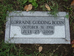
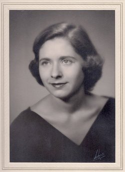
Leota Lorraine Godding Bodin
| Birth | : | 31 Oct 1931 Wichita, Sedgwick County, Kansas, USA |
| Death | : | 27 Jul 2008 Lawrence, Douglas County, Kansas, USA |
| Burial | : | Oak Hill Cemetery, Lawrence, Douglas County, USA |
| Coordinate | : | 38.9589005, -95.2118988 |
| Plot | : | Section 16, Lot 201, Gr. 5 |
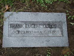
| Description | : | ******************************************* Services for Lorraine G. Bodin, 76, Lawrence, will be at 2 p.m. Wednesday at Rumsey-Yost Funeral Home. Burial will be in Oak Hill Cemetery. Mrs. Bodin died Sunday, July 27, 2008, at Lawrence Memorial Hospital. She was born Oct. 31, 1931, in Wichita, the daughter of Frank E. and Leota Catherine Godding. She was a resident of The Windsor in Lawrence. Mrs. Bodin was a business manager of KLWN-KLZR Radio for many years. She was a longtime member of Chi Omega sorority and also a member of Plymouth Congregational Church. Survivors include two sons, Michael Bodin, Chicago, and Jeffrey Bodin and wife Michelle, Salt... Read More |
frequently asked questions (FAQ):
-
Where is Leota Lorraine Godding Bodin's memorial?
Leota Lorraine Godding Bodin's memorial is located at: Oak Hill Cemetery, Lawrence, Douglas County, USA.
-
When did Leota Lorraine Godding Bodin death?
Leota Lorraine Godding Bodin death on 27 Jul 2008 in Lawrence, Douglas County, Kansas, USA
-
Where are the coordinates of the Leota Lorraine Godding Bodin's memorial?
Latitude: 38.9589005
Longitude: -95.2118988
Family Members:
Parent

Spouse

Siblings
Flowers:


Nearby Cemetories:
1. Oak Hill Cemetery
Lawrence, Douglas County, USA
Coordinate: 38.9589005, -95.2118988
2. Mount Calvary Catholic Cemetery
Lawrence, Douglas County, USA
Coordinate: 38.9580002, -95.2139969
3. Memorial Park Cemetery
Lawrence, Douglas County, USA
Coordinate: 38.9552994, -95.2153015
4. Trinity Episcopal Church Columbarium
Lawrence, Douglas County, USA
Coordinate: 38.9653893, -95.2373886
5. Saint Johns Catholic Cemetery
Douglas County, USA
Coordinate: 38.9437900, -95.1919600
6. Dyche Hall Natural History Museum
Lawrence, Douglas County, USA
Coordinate: 38.9584800, -95.2434800
7. Franklin Cemetery
Douglas County, USA
Coordinate: 38.9437523, -95.1869431
8. Haskell Cemetery
Lawrence, Douglas County, USA
Coordinate: 38.9353790, -95.2284241
9. Pioneer Cemetery
Lawrence, Douglas County, USA
Coordinate: 38.9528008, -95.2611008
10. First Presbyterian Church Memorial Garden
Lawrence, Douglas County, USA
Coordinate: 38.9414900, -95.2641600
11. Maple Grove Cemetery
Lawrence, Douglas County, USA
Coordinate: 39.0018997, -95.2316971
12. County Poor Farm Cemetery
Douglas County, USA
Coordinate: 38.9119400, -95.2214600
13. Adams Cemetery
Douglas County, USA
Coordinate: 38.9955400, -95.2509100
14. Kennedy Cemetery
Douglas County, USA
Coordinate: 38.9112900, -95.2269200
15. Davis Cemetery
Lawrence, Douglas County, USA
Coordinate: 38.9722500, -95.2831100
16. Blue Mound Cemetery
Lawrence, Douglas County, USA
Coordinate: 38.9046600, -95.1865400
17. Marshall Cemetery
Douglas County, USA
Coordinate: 38.9040800, -95.2446700
18. Dutton Cemetery
Douglas County, USA
Coordinate: 38.8989800, -95.2790600
19. Luckan Family Cemetery
Fall Leaf, Leavenworth County, USA
Coordinate: 38.9808500, -95.1128000
20. Cemetery Beni Israel
Eudora, Douglas County, USA
Coordinate: 38.9280128, -95.1122208
21. Southwest City Cemetery
Eudora, Douglas County, USA
Coordinate: 38.9334800, -95.1070300
22. Lyon Family Cemetery
Lawrence, Douglas County, USA
Coordinate: 38.9877440, -95.3166530
23. Corpus Christi Catholic Church Columbarium
Lawrence, Douglas County, USA
Coordinate: 38.9572250, -95.3238450
24. Richland Cemetery
Lawrence, Douglas County, USA
Coordinate: 38.8768997, -95.2630997