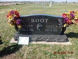
Leslie W. “Les” Root
| Birth | : | 6 Oct 1938 Dallas County, Iowa, USA |
| Death | : | 16 Jan 2020 Morganville, Clay County, Kansas, USA |
| Burial | : | Bloom Cemetery, Morganville, Clay County, USA |
| Coordinate | : | 39.4519005, -97.2778015 |
| Description | : | Leslie W. Root passed away peacefully on January 16, 2020 at his home in Morganville, KS. He was born October 6, 1938 in Dallas County, Iowa to Lester Ora and Hazel Lillian (Powell) Root. He married Donna Blanchard on December 28, 1973. He farmed in Iowa with his father and was employed in York, Nebraska at Sperry New Halland, and Agi Con/Equipment in Central City, Iowa. Les then moved to Kansas and was employed with AgCo Corporation until his retirement in 2004. Les also worked as a crop insurance adjuster for Great American Insurance after his retirement. He was... Read More |
frequently asked questions (FAQ):
-
Where is Leslie W. “Les” Root's memorial?
Leslie W. “Les” Root's memorial is located at: Bloom Cemetery, Morganville, Clay County, USA.
-
When did Leslie W. “Les” Root death?
Leslie W. “Les” Root death on 16 Jan 2020 in Morganville, Clay County, Kansas, USA
-
Where are the coordinates of the Leslie W. “Les” Root's memorial?
Latitude: 39.4519005
Longitude: -97.2778015
Family Members:
Parent
Spouse
Flowers:
Nearby Cemetories:
1. Bloom Cemetery
Morganville, Clay County, USA
Coordinate: 39.4519005, -97.2778015
2. Lincoln Cemetery
Clay Center, Clay County, USA
Coordinate: 39.4230995, -97.2930984
3. Iwacura Cemetery
Morganville, Clay County, USA
Coordinate: 39.4550000, -97.3510000
4. Riverdale Cemetery
Clay County, USA
Coordinate: 39.5106010, -97.2930984
5. Morganville City Cemetery
Morganville, Clay County, USA
Coordinate: 39.4733009, -97.1819000
6. Norwegian Lutheran Cemetery
Clay Center, Clay County, USA
Coordinate: 39.5027900, -97.1828200
7. Sherman Cemetery
Morganville, Clay County, USA
Coordinate: 39.5316300, -97.2243700
8. Idana Cemetery
Idana, Clay County, USA
Coordinate: 39.3574500, -97.2693300
9. Wilson Cemetery
Clay County, USA
Coordinate: 39.3800011, -97.1896973
10. French Presbyterian Church Cemetery
Cloud County, USA
Coordinate: 39.4395200, -97.4148290
11. Swedish Evangelical Lutheran Cemetery
Clay County, USA
Coordinate: 39.4911700, -97.1455100
12. Saint Joseph Cemetery
Saint Joseph, Cloud County, USA
Coordinate: 39.5074941, -97.4022328
13. Swedish Pleasant Hill Cemetery
Clay Center, Clay County, USA
Coordinate: 39.4735985, -97.1268997
14. Greenwood Cemetery
Clay Center, Clay County, USA
Coordinate: 39.4011002, -97.1275024
15. Saint Peter and Saint Pauls Catholic Cemetery
Clay Center, Clay County, USA
Coordinate: 39.4005450, -97.1236680
16. Hebron Cemetery
Clay County, USA
Coordinate: 39.3213800, -97.2601400
17. Garfield Center Mission Cemetery
Clay Center, Clay County, USA
Coordinate: 39.5243100, -97.1277500
18. Table Mound Cemetery
Idana, Clay County, USA
Coordinate: 39.3141300, -97.2792300
19. Cedar Grove Cemetery
Clyde, Cloud County, USA
Coordinate: 39.5494003, -97.4056015
20. Republican City Cemetery
Clay Center, Clay County, USA
Coordinate: 39.3431015, -97.1628036
21. Shields Cemetery
Clay County, USA
Coordinate: 39.3208008, -97.3507996
22. Smith Grave
Miltonvale, Cloud County, USA
Coordinate: 39.3645300, -97.4308700
23. Hayes Cemetery
Clay County, USA
Coordinate: 39.4516983, -97.0811005
24. Pleasant View Cemetery
Ames, Cloud County, USA
Coordinate: 39.5346985, -97.4431000


