


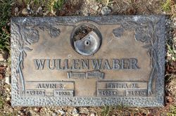
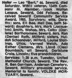
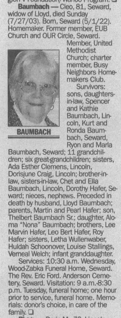
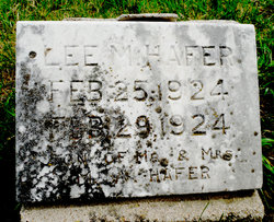
Letha Marie Hafer Wullenwaber
| Birth | : | 25 Feb 1924 Seward, Seward County, Nebraska, USA |
| Death | : | 23 Jun 1980 Contra Costa County, California, USA |
| Burial | : | Rolling Hills Memorial Park, Richmond, Contra Costa County, USA |
| Coordinate | : | 37.9756012, -122.3146973 |
| Plot | : | Serenity, Lot 1815, Space 4 |
frequently asked questions (FAQ):
-
Where is Letha Marie Hafer Wullenwaber's memorial?
Letha Marie Hafer Wullenwaber's memorial is located at: Rolling Hills Memorial Park, Richmond, Contra Costa County, USA.
-
When did Letha Marie Hafer Wullenwaber death?
Letha Marie Hafer Wullenwaber death on 23 Jun 1980 in Contra Costa County, California, USA
-
Where are the coordinates of the Letha Marie Hafer Wullenwaber's memorial?
Latitude: 37.9756012
Longitude: -122.3146973
Family Members:
Parent
Spouse
Siblings

Flowers:


Nearby Cemetories:
1. Rolling Hills Memorial Park
Richmond, Contra Costa County, USA
Coordinate: 37.9756012, -122.3146973
2. Saint Joseph Catholic Cemetery
San Pablo, Contra Costa County, USA
Coordinate: 37.9612700, -122.3336600
3. Saint Pauls Cemetery (Defunct)
San Pablo, Contra Costa County, USA
Coordinate: 37.9563332, -122.3430099
4. Salesian Cemetery
Richmond, Contra Costa County, USA
Coordinate: 37.9532650, -122.3401230
5. Sunset View Cemetery
El Cerrito, Contra Costa County, USA
Coordinate: 37.9077721, -122.2871017
6. Golden Gate Mausoleum and Columbaria
El Cerrito, Contra Costa County, USA
Coordinate: 37.9073150, -122.2857220
7. Golden Gate Fields
Albany, Alameda County, USA
Coordinate: 37.8854000, -122.3117000
8. Northbrae Community Church Columbarium
Berkeley, Alameda County, USA
Coordinate: 37.8905500, -122.2763200
9. Gan Shalom Cemetery
Contra Costa County, USA
Coordinate: 37.9528122, -122.1975098
10. Rags Gravesite
Crockett, Contra Costa County, USA
Coordinate: 38.0561765, -122.2257217
11. Mare Island Cemetery
Vallejo, Solano County, USA
Coordinate: 38.0796738, -122.2527008
12. Glen Cove Sacred Indian Burial Grounds
Vallejo, Solano County, USA
Coordinate: 38.0680620, -122.2064640
13. Saint Stephens Episcopal Church Memorial Garden
Orinda, Contra Costa County, USA
Coordinate: 37.8982650, -122.1729170
14. Carquinez Cemetery
Vallejo, Solano County, USA
Coordinate: 38.0889015, -122.2108002
15. Saint Vincents Cemetery
Vallejo, Solano County, USA
Coordinate: 38.0881004, -122.2089005
16. Saint Catherine of Siena Cemetery
Martinez, Contra Costa County, USA
Coordinate: 38.0172005, -122.1446991
17. All Souls Catholic Cemetery
Vallejo, Solano County, USA
Coordinate: 38.0881690, -122.2077890
18. San Quentin Prison Cemetery
San Rafael, Marin County, USA
Coordinate: 37.9436480, -122.4883760
19. Alhambra Cemetery
Martinez, Contra Costa County, USA
Coordinate: 38.0182991, -122.1442032
20. Skyview Memorial Lawn
Vallejo, Solano County, USA
Coordinate: 38.0920460, -122.2080320
21. Angel Island Cemetery (defunct)
Tiburon, Marin County, USA
Coordinate: 37.8621830, -122.4325920
22. Hillside Cemetery
Vallejo, Solano County, USA
Coordinate: 38.1185989, -122.2647018
23. Sunrise Memorial Cemetery
Vallejo, Solano County, USA
Coordinate: 38.1194000, -122.2605972
24. Lafayette-Orinda Presbyterian Church Garden
Contra Costa County, USA
Coordinate: 37.8866040, -122.1606950