
| Birth | : | 21 May 1915 Ottumwa, Wapello County, Iowa, USA |
| Death | : | 16 Dec 1977 Wapello County, Iowa, USA |
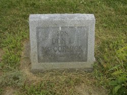
| Burial | : | Church Hill Cemetery, Ashland, Grafton County, USA |
| Coordinate | : | 43.7455560, -71.6522220 |
| Description | : | Courtesy of the Ottumwa Courier Dec. 18, 1977 Mrs. Lettie G. McCormick 63 of 331 North Moore was found dead at her home Dec. 18. Death was from natural causes according to the Wapello County medical examiner. She was a retired Morrell & Co. employee who was born May 21, 1915 in Ottumwa, to Ernest and Hazel Pherigo Richardson. She married Don L. McCormick Jan. 1, 1949 at Ottumwa. He died in 1960. Survivors include a son; Bernard F. Jackson of Hilliard, Ohio; sisters; Verla Randolph, Margery Ware, Geraldine Hartley and Delores James all of Ottumwa, and Dorothy McDonald of Washington, ILL., and... Read More |
frequently asked questions (FAQ):
-
Where is Lettie Richardson McCormick's memorial?
Lettie Richardson McCormick's memorial is located at: Church Hill Cemetery, Ashland, Grafton County, USA.
-
When did Lettie Richardson McCormick death?
Lettie Richardson McCormick death on 16 Dec 1977 in Wapello County, Iowa, USA
-
Where are the coordinates of the Lettie Richardson McCormick's memorial?
Latitude: 43.7455560
Longitude: -71.6522220
Family Members:
Parent
Spouse

Siblings
Flowers:


Nearby Cemetories:
1. Church Hill Cemetery
Ashland, Grafton County, USA
Coordinate: 43.7455560, -71.6522220
2. Trinity Churchyard Cemetery
Holderness, Grafton County, USA
Coordinate: 43.7566000, -71.6696700
3. Owl Brook Cemetery
Ashland, Grafton County, USA
Coordinate: 43.7333200, -71.6300100
4. Lower Intervale Cemetery
Plymouth, Grafton County, USA
Coordinate: 43.7316100, -71.6733800
5. Shaw Cemetery
Holderness, Grafton County, USA
Coordinate: 43.7436110, -71.6225000
6. Hicks Hill Cemetery
Ashland, Grafton County, USA
Coordinate: 43.7277780, -71.6313890
7. Sanborn Cemetery
Holderness, Grafton County, USA
Coordinate: 43.7612800, -71.6050600
8. Riverside Cemetery
Plymouth, Grafton County, USA
Coordinate: 43.7736000, -71.6908100
9. Union Cemetery
Bridgewater, Grafton County, USA
Coordinate: 43.7093500, -71.6763500
10. Clark Cemetery
Ashland, Grafton County, USA
Coordinate: 43.7133330, -71.6113890
11. Howe-Clark Cemetery
Grafton County, USA
Coordinate: 43.7133330, -71.6113890
12. Mitchell Family Cemetery
Bridgewater, Grafton County, USA
Coordinate: 43.7052780, -71.6838890
13. Mooney Cemetery
Ashland, Grafton County, USA
Coordinate: 43.7019440, -71.6269440
14. Squam Bridge Cemetery
Holderness, Grafton County, USA
Coordinate: 43.7316500, -71.5887200
15. Green Grove Cemetery
Ashland, Grafton County, USA
Coordinate: 43.6975400, -71.6401500
16. Thompson Street Cemetery
Ashland, Grafton County, USA
Coordinate: 43.6975100, -71.6294000
17. Ashland Episcopal Church Cemetery
Ashland, Grafton County, USA
Coordinate: 43.6963650, -71.6315670
18. Dearborn Cemetery
Plymouth, Grafton County, USA
Coordinate: 43.7597220, -71.7213890
19. Baker Cemetery
Ashland, Grafton County, USA
Coordinate: 43.6941990, -71.6254580
20. Prescott Cemetery
Holderness, Grafton County, USA
Coordinate: 43.7546400, -71.5682400
21. Kenfield Cemetery
Bridgewater, Grafton County, USA
Coordinate: 43.6837070, -71.6503550
22. Burleigh-Carr Cemetery
Holderness, Grafton County, USA
Coordinate: 43.7583600, -71.5675200
23. Blair Cemetery
Campton, Grafton County, USA
Coordinate: 43.8111000, -71.6603012
24. Bartlett Cemetery
Plymouth, Grafton County, USA
Coordinate: 43.7542400, -71.7436200