

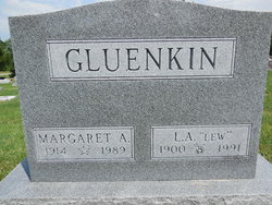
Lewis A “Lew” Gluenkin
| Birth | : | 15 Feb 1897 Lexington, Dawson County, Nebraska, USA |
| Death | : | 3 Jul 1991 Iowa, USA |
| Burial | : | Evergreen Cemetery, Fairfield, Jefferson County, USA |
| Coordinate | : | 41.0138600, -91.9562100 |
| Plot | : | 4th.064 |
| Description | : | Note: this memorial updated Jan. 31, 2019 with DOB/DOD locations and obituary transcription. ----------------------- Fairfield Ledger Friday July 5, 1991 Lewis A. Gluenkin The funeral service for Lewis A. Gluenkin, 94, who died July 3, 1991, will be at 10:30 a.m. Saturday at the Raymond Funeral Home with the Rev. Richard K. Wallarab officiating. Burial will be in Evergreen Cemetery. Gluenkin was born Feb. 15, 1897, at Lexington, Neb., to John and Johanna Van Veest Gluenkin. He married Anna Margaret (sic. a/k/a Margaret Anna) Vanderzyl July 21, 1943. She died on Aug. 15, 1989. |
frequently asked questions (FAQ):
-
Where is Lewis A “Lew” Gluenkin's memorial?
Lewis A “Lew” Gluenkin's memorial is located at: Evergreen Cemetery, Fairfield, Jefferson County, USA.
-
When did Lewis A “Lew” Gluenkin death?
Lewis A “Lew” Gluenkin death on 3 Jul 1991 in Iowa, USA
-
Where are the coordinates of the Lewis A “Lew” Gluenkin's memorial?
Latitude: 41.0138600
Longitude: -91.9562100
Family Members:
Parent
Spouse
Siblings

Flowers:


Nearby Cemetories:
1. Evergreen Cemetery
Fairfield, Jefferson County, USA
Coordinate: 41.0138600, -91.9562100
2. Old Fairfield Cemetery
Fairfield, Jefferson County, USA
Coordinate: 41.0148000, -91.9598000
3. Memorial Lawn Cemetery
Fairfield, Jefferson County, USA
Coordinate: 41.0068000, -91.9805000
4. Switzer Cemetery
Fairfield, Jefferson County, USA
Coordinate: 41.0368996, -91.9096985
5. Bradshaw Cemetery
Jefferson County, USA
Coordinate: 40.9766998, -91.9032974
6. Roth Cemetery
Fairfield, Jefferson County, USA
Coordinate: 40.9589005, -91.9574966
7. Bethesda Cemetery
Fairfield, Jefferson County, USA
Coordinate: 41.0019000, -91.8796000
8. Smith Family Cemetery
Libertyville, Jefferson County, USA
Coordinate: 40.9972416, -92.0362857
9. Wheeler Cemetery
Jefferson County, USA
Coordinate: 41.0797000, -91.9185500
10. Galliher Cemetery
Glasgow, Jefferson County, USA
Coordinate: 40.9666892, -91.8835038
11. Upper Richwoods Cemetery
Salina, Jefferson County, USA
Coordinate: 41.0602989, -91.8807983
12. Jefferson County Poor Farm Cemetery
Libertyville, Jefferson County, USA
Coordinate: 40.9416900, -91.9996200
13. Perlee Cemetery
Perlee, Jefferson County, USA
Coordinate: 41.0805750, -91.8993380
14. Pattison Cemetery
Fairfield, Jefferson County, USA
Coordinate: 40.9444008, -91.9049988
15. Moorman Cemetery
Fairfield, Jefferson County, USA
Coordinate: 41.0452995, -92.0622025
16. Wright Cemetery
Fairfield, Jefferson County, USA
Coordinate: 40.9524000, -91.8728000
17. Antioch Cemetery
Fairfield, Jefferson County, USA
Coordinate: 41.1002998, -91.9147034
18. Moyer Cemetery
Fairfield, Jefferson County, USA
Coordinate: 41.1046982, -91.9330978
19. Cumberland Cemetery
Jefferson County, USA
Coordinate: 40.9248000, -91.9903000
20. Gregg Cemetery
Jefferson County, USA
Coordinate: 41.0078011, -92.0811005
21. Salina Cemetery
Salina, Jefferson County, USA
Coordinate: 41.0419006, -91.8330994
22. McCleary Cemetery
Jefferson County, USA
Coordinate: 40.9892006, -92.0805969
23. Brooks Cemetery
Jefferson County, USA
Coordinate: 41.0635986, -92.0693970
24. Thompson Cemetery
Jefferson County, USA
Coordinate: 40.9155998, -91.9772034