
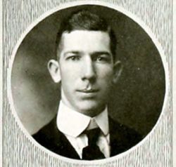

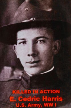
Lieut Edward Cedric Harris
| Birth | : | 20 May 1896 Vance County, North Carolina, USA |
| Death | : | 11 Nov 1918 France |
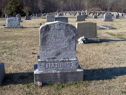
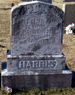
| Burial | : | St. Peter's Churchyard, Stockport, Metropolitan Borough of Stockport, England |
| Coordinate | : | 53.4105000, -2.1587000 |
| Plot | : | K 81st Divison - Book O |
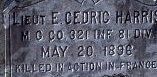
| Inscription | : | MG Co 321 INF 81 Div Killed in action in France. He gave his life for his God and country |
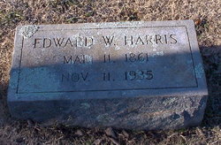
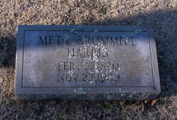
| Description | : | Cedric Harris was one of 5 children of Edward W. Harris and Meta Earl Brummitt. He graduated from Trinity College in 1917 and entered service April, 1917, at Wendell, N. C. He went to Ft. Oglethorpe, Ga. and sailed for France Aug. 5, 1918 as a 2nd Lt., with the Machine Gun Co., 81st Div. 321st Inf. He was mortally wounded in action on Nov. 11, the day the armistice was signed between Germany and the allies and died the following day. He was helping to care for his wounded men and received a fatal... Read More |
frequently asked questions (FAQ):
-
Where is Lieut Edward Cedric Harris's memorial?
Lieut Edward Cedric Harris's memorial is located at: St. Peter's Churchyard, Stockport, Metropolitan Borough of Stockport, England.
-
When did Lieut Edward Cedric Harris death?
Lieut Edward Cedric Harris death on 11 Nov 1918 in France
-
Where are the coordinates of the Lieut Edward Cedric Harris's memorial?
Latitude: 53.4105000
Longitude: -2.1587000
Family Members:
Parent
Siblings
Flowers:


Nearby Cemetories:
1. St. Peter's Churchyard
Stockport, Metropolitan Borough of Stockport, England
Coordinate: 53.4105000, -2.1587000
2. St. Mary's Churchyard
Stockport, Metropolitan Borough of Stockport, England
Coordinate: 53.4112340, -2.1555140
3. Stockport Quaker Burial Ground (Defunct)
Stockport, Metropolitan Borough of Stockport, England
Coordinate: 53.4096205, -2.1555406
4. The Parish Church of Saint Peter
Stockport, Metropolitan Borough of Stockport, England
Coordinate: 53.4084880, -2.1492930
5. Christ Church
Heaton Norris, Metropolitan Borough of Stockport, England
Coordinate: 53.4144000, -2.1678000
6. St Thomas Churchyard
Stockport, Metropolitan Borough of Stockport, England
Coordinate: 53.4036000, -2.1550000
7. Wesleyan Chapel
Edgeley, Metropolitan Borough of Stockport, England
Coordinate: 53.4019700, -2.1673860
8. Stockport Cemetery and Crematorium
Stockport, Metropolitan Borough of Stockport, England
Coordinate: 53.3979110, -2.1511430
9. St. Paul's Churchyard
Portwood, Metropolitan Borough of Stockport, England
Coordinate: 53.4215604, -2.1717953
10. Willow Grove Cemetery
Stockport, Metropolitan Borough of Stockport, England
Coordinate: 53.4252900, -2.1508100
11. Saint Thomas the Apostle Heaton Chapel
Heaton Norris, Metropolitan Borough of Stockport, England
Coordinate: 53.4297783, -2.1797558
12. Heaton Mersey Congregational Churchyard
Stockport, Metropolitan Borough of Stockport, England
Coordinate: 53.4128680, -2.2038150
13. St Elisabeth Church
Reddish, Metropolitan Borough of Stockport, England
Coordinate: 53.4379400, -2.1633950
14. Highfield Cemetery
Bredbury, Metropolitan Borough of Stockport, England
Coordinate: 53.4133310, -2.1111320
15. St. John the Baptist Churchyard
Heaton Mersey, Metropolitan Borough of Stockport, England
Coordinate: 53.4124526, -2.2064749
16. Cheadle Cemetery
Cheadle, Metropolitan Borough of Stockport, England
Coordinate: 53.3927610, -2.2054690
17. Saint Mark Churchyard
Bredbury, Metropolitan Borough of Stockport, England
Coordinate: 53.4241160, -2.1051390
18. Hatherlow Chapel Cemetery
Bredbury, Metropolitan Borough of Stockport, England
Coordinate: 53.4109259, -2.0992592
19. Mill Lane Cemetery
Cheadle, Metropolitan Borough of Stockport, England
Coordinate: 53.3992000, -2.2150800
20. Hatherlow United Reformed Church Cemetery
Romiley, Metropolitan Borough of Stockport, England
Coordinate: 53.4107180, -2.0989830
21. St Mary's Churchyard
Cheadle, Metropolitan Borough of Stockport, England
Coordinate: 53.3944820, -2.2176205
22. Saint Chad's Churchyard
Romiley, Metropolitan Borough of Stockport, England
Coordinate: 53.4128520, -2.0896350
23. Denton Cemetery
Denton, Metropolitan Borough of Tameside, England
Coordinate: 53.4424140, -2.1115510
24. Parsonage Gardens
Didsbury, Metropolitan Borough of Manchester, England
Coordinate: 53.4094440, -2.2302780