
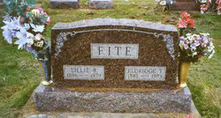
Lillie Belle Lanman Fite
| Birth | : | 30 Sep 1886 Davis County, Iowa, USA |
| Death | : | 1 Apr 1959 Bloomfield, Davis County, Iowa, USA |
| Burial | : | Elmswell Cemetery, Elmswell, Mid Suffolk District, England |
| Coordinate | : | 52.2328720, 0.8992110 |
| Plot | : | Section IV |
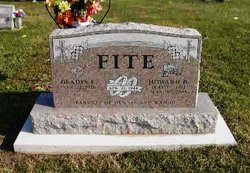
| Description | : | Wife to Eldridge Temple Fite. Daughter of Elias Sylvester & Margaret Ann Lynch Lanman. Mrs. Eldridge Fite, 72, died at the Cameron nursing home at Bloomfield at 3:30 a.m. Wednesday. She had been seriously ill since Thursday and in poor health for 20 years. Born September 30, 1886, she was the daughter of Sylvester and Margaret Lynch Lanman. She was born in Davis county and spent her life in the Bethlehem community. She was a member of the Bethlehem church. On October 19, 1901 she was married to Eldridge Fite, who survives. Also surviving are four sons, Donald Fite of... Read More |
frequently asked questions (FAQ):
-
Where is Lillie Belle Lanman Fite's memorial?
Lillie Belle Lanman Fite's memorial is located at: Elmswell Cemetery, Elmswell, Mid Suffolk District, England.
-
When did Lillie Belle Lanman Fite death?
Lillie Belle Lanman Fite death on 1 Apr 1959 in Bloomfield, Davis County, Iowa, USA
-
Where are the coordinates of the Lillie Belle Lanman Fite's memorial?
Latitude: 52.2328720
Longitude: 0.8992110
Family Members:
Parent

Spouse

Siblings

Children
Flowers:


Nearby Cemetories:
1. Elmswell Cemetery
Elmswell, Mid Suffolk District, England
Coordinate: 52.2328720, 0.8992110
2. St John the Divine Churchyard
Elmswell, Mid Suffolk District, England
Coordinate: 52.2350000, 0.9014815
3. Methodist Church Burial Ground
Elmswell, Mid Suffolk District, England
Coordinate: 52.2371320, 0.9097780
4. All Saints Churchyard
Drinkstone, Mid Suffolk District, England
Coordinate: 52.2178910, 0.8674070
5. Norton Baptist Church
Norton, Mid Suffolk District, England
Coordinate: 52.2541360, 0.8657970
6. St. Andrew's Churchyard
Norton, Mid Suffolk District, England
Coordinate: 52.2600350, 0.8737990
7. King Charles the Martyr Churchyard
Shelland, Mid Suffolk District, England
Coordinate: 52.2039070, 0.9307170
8. Rattlesden Cemetery
Rattlesden, Mid Suffolk District, England
Coordinate: 52.1961530, 0.8947200
9. St Nicholas Churchyard
Rattlesden, Mid Suffolk District, England
Coordinate: 52.1941810, 0.8926210
10. Rattlesden Baptist Church
Rattlesden, Mid Suffolk District, England
Coordinate: 52.1924020, 0.8885300
11. St. Mary the Virgin's Church
Haughley, Mid Suffolk District, England
Coordinate: 52.2215800, 0.9647260
12. St Ethelbert Churchyard
Hessett, Mid Suffolk District, England
Coordinate: 52.2206810, 0.8341060
13. All Saints Churchyard
Great Ashfield, Mid Suffolk District, England
Coordinate: 52.2719990, 0.9234480
14. St Michael Churchyard
Hunston, Mid Suffolk District, England
Coordinate: 52.2750420, 0.8947420
15. All Saints Churchyard
Beyton, Mid Suffolk District, England
Coordinate: 52.2290300, 0.8301100
16. St. Augustine's Church Burial Ground
Harleston, Mid Suffolk District, England
Coordinate: 52.2045920, 0.9526440
17. St George Churchyard
Stowlangtoft, Mid Suffolk District, England
Coordinate: 52.2771010, 0.8683970
18. St John the Baptist Churchyard
Onehouse, Mid Suffolk District, England
Coordinate: 52.1956290, 0.9495420
19. Badwell Ash Cemetery
Badwell Ash, Mid Suffolk District, England
Coordinate: 52.2822470, 0.9168550
20. St. Mary's in the Field
Langham, Mid Suffolk District, England
Coordinate: 52.2837690, 0.9022270
21. Saint Mary Churchyard
Badwell Ash, Mid Suffolk District, England
Coordinate: 52.2829360, 0.9152840
22. St. Mary's Churchyard
Gedding, Mid Suffolk District, England
Coordinate: 52.1865920, 0.8540510
23. Saint Mary's Churchyard
Buxhall, Mid Suffolk District, England
Coordinate: 52.1803740, 0.9283610
24. St Mary Parish Churchyard
Pakenham, St Edmundsbury Borough, England
Coordinate: 52.2678260, 0.8268340