

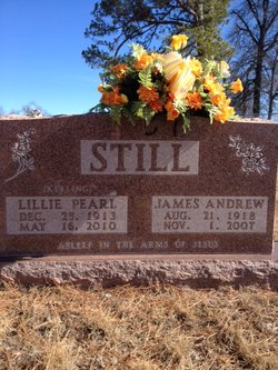
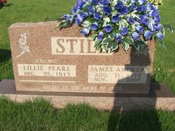
Lillie Pearl Keeling Still
| Birth | : | 25 Dec 1913 Searcy County, Arkansas, USA |
| Death | : | 16 May 2010 Arkansas, USA |
| Burial | : | St. Mary the Virgin Churchyard, Southery, Kings Lynn and West Norfolk Borough, England |
| Coordinate | : | 52.5249310, 0.3894790 |
| Description | : | Lillie Pearl Still December 25, 1913 - May 16, 2010 Lillie Pearl Still, age 96, of St. Joe, Arkansas passed away Sunday, May 16, 2010. She was born in Searcy County on December 25, 1913. Mrs. Still was a member of the Pilot Mt. Primitive Baptist Church. She will be remembered for her generosity and hospitality. Her wonderful home cooking ensured all visitors went away satisfied. Mrs. Still loved working in her flower garden and quilting but the time spent visiting with friends and family was among her most cherished moments. Lillie Pearl Still was preceded in death by her parents, William... Read More |
frequently asked questions (FAQ):
-
Where is Lillie Pearl Keeling Still's memorial?
Lillie Pearl Keeling Still's memorial is located at: St. Mary the Virgin Churchyard, Southery, Kings Lynn and West Norfolk Borough, England.
-
When did Lillie Pearl Keeling Still death?
Lillie Pearl Keeling Still death on 16 May 2010 in Arkansas, USA
-
Where are the coordinates of the Lillie Pearl Keeling Still's memorial?
Latitude: 52.5249310
Longitude: 0.3894790
Family Members:
Parent
Spouse
Siblings
Children


Nearby Cemetories:
1. St. Mary the Virgin Churchyard
Southery, Kings Lynn and West Norfolk Borough, England
Coordinate: 52.5249310, 0.3894790
2. All Saints Churchyard
Hilgay, Kings Lynn and West Norfolk Borough, England
Coordinate: 52.5574000, 0.3911690
3. St Mary Churchyard
Denver, Kings Lynn and West Norfolk Borough, England
Coordinate: 52.5886240, 0.3819980
4. St. Michael's Churchyard
Ryston, Kings Lynn and West Norfolk Borough, England
Coordinate: 52.5895310, 0.3912770
5. Rouse's Lane
Downham Market, Kings Lynn and West Norfolk Borough, England
Coordinate: 52.6007020, 0.3874400
6. King's Walk Cemetery
Downham Market, Kings Lynn and West Norfolk Borough, England
Coordinate: 52.6025160, 0.3808160
7. Churchside Cemetery
Downham Market, Kings Lynn and West Norfolk Borough, England
Coordinate: 52.6027720, 0.3807240
8. St. Andrew's Churchyard
West Dereham, Kings Lynn and West Norfolk Borough, England
Coordinate: 52.5911080, 0.4599020
9. Nordelph Cemetery
Nordelph, Kings Lynn and West Norfolk Borough, England
Coordinate: 52.5836400, 0.3015100
10. Saint Mary the Virgin Churchyard
Bexwell, Kings Lynn and West Norfolk Borough, England
Coordinate: 52.6040000, 0.4076000
11. St. Margaret of Antioch Churchyard
Wereham, Kings Lynn and West Norfolk Borough, England
Coordinate: 52.5867700, 0.4799200
12. St. Mary the Virgin Churchyard
Welney, Kings Lynn and West Norfolk Borough, England
Coordinate: 52.5212100, 0.2479820
13. Littleport Cemetery
Littleport, East Cambridgeshire District, England
Coordinate: 52.4591154, 0.2954870
14. St Nicholas Churchyard
Feltwell, Kings Lynn and West Norfolk Borough, England
Coordinate: 52.4888000, 0.5209700
15. All Saints Churchyard
Stoke Ferry, Kings Lynn and West Norfolk Borough, England
Coordinate: 52.5702970, 0.5138070
16. St. Mary's Churchyard
Feltwell, Kings Lynn and West Norfolk Borough, England
Coordinate: 52.4874580, 0.5245110
17. All Saints Churchyard
Boughton, Kings Lynn and West Norfolk Borough, England
Coordinate: 52.5913020, 0.5080360
18. Holy Trinity Churchyard
Stow Bardolph, Kings Lynn and West Norfolk Borough, England
Coordinate: 52.6241340, 0.4041480
19. St. George's Churchyard
Methwold, Kings Lynn and West Norfolk Borough, England
Coordinate: 52.5229060, 0.5568700
20. St. Mary's Churchyard
Stradsett, Kings Lynn and West Norfolk Borough, England
Coordinate: 52.6178500, 0.4588500
21. Methwold Cemetery
Methwold, Kings Lynn and West Norfolk Borough, England
Coordinate: 52.5257758, 0.5575197
22. St. Peter's Churchyard
Stow Bridge, Kings Lynn and West Norfolk Borough, England
Coordinate: 52.6312500, 0.3508300
23. St. Peter Church Cemetery
Hockwold, Kings Lynn and West Norfolk Borough, England
Coordinate: 52.4627780, 0.5376030
24. Christ Church Churchyard
Christchurch, Fenland District, England
Coordinate: 52.5456560, 0.2007360