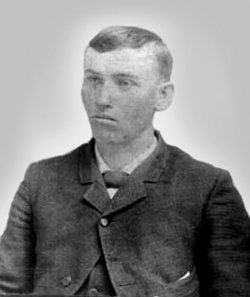
| Birth | : | 19 Nov 1871 Monroe County, Kentucky, USA |
| Death | : | 9 Sep 1898 Humboldt, Richardson County, Nebraska, USA |
| Burial | : | Lynchburg Cemetery, Humboldt, Richardson County, USA |
| Coordinate | : | 40.1306000, -95.9068985 |
| Description | : | Lina Cora Grinstead was the third child of six, and the second daughter, born to, Captain John Philip Grinstead, and his wife, Zerelda Tunstall [SHIRLEY] Grinstead. She was born in Apple Grove, Monroe County, Kentucky, 19 November 1871. On, 25 October 1888, she married, Thomas McClellen Allen. He was the third child of six, and the eldest son, born to, Jesse Bennett Allen, and his wife, Sarah Catherine [LYNCH] Allen. He was born in Clinton County, Indiana on, 24 December 1864. Together, Thomas and his wife, Cora [GRINSTEAD] Allen, would share three children. Cora caught tuberculosis and died in Humboldt,... Read More |
frequently asked questions (FAQ):
-
Where is Lina Cora Grinstead Allen's memorial?
Lina Cora Grinstead Allen's memorial is located at: Lynchburg Cemetery, Humboldt, Richardson County, USA.
-
When did Lina Cora Grinstead Allen death?
Lina Cora Grinstead Allen death on 9 Sep 1898 in Humboldt, Richardson County, Nebraska, USA
-
Where are the coordinates of the Lina Cora Grinstead Allen's memorial?
Latitude: 40.1306000
Longitude: -95.9068985
Family Members:
Parent
Spouse
Siblings
Children
Flowers:
Nearby Cemetories:
1. Lynchburg Cemetery
Humboldt, Richardson County, USA
Coordinate: 40.1306000, -95.9068985
2. Starr Cemetery
Dawson, Richardson County, USA
Coordinate: 40.1464005, -95.8692017
3. Humboldt Cemetery
Humboldt, Richardson County, USA
Coordinate: 40.1610985, -95.9578018
4. Saint Marys Cemetery
Dawson, Richardson County, USA
Coordinate: 40.1307983, -95.8414001
5. Heim Cemetery
Dawson, Richardson County, USA
Coordinate: 40.1380997, -95.8328018
6. Bohemian Cemetery
Richardson County, USA
Coordinate: 40.1175003, -95.9955978
7. Iliff Cemetery
Dawson, Richardson County, USA
Coordinate: 40.1241989, -95.8127975
8. Mound Cemetery
Humboldt, Richardson County, USA
Coordinate: 40.1960983, -95.8602982
9. Four Mile Cemetery
Humboldt, Richardson County, USA
Coordinate: 40.0589000, -95.9455000
10. Dry Branch Pioneer Cemetery
Richardson County, USA
Coordinate: 40.1292000, -96.0100021
11. Pleasant Hill Cemetery
Richardson County, USA
Coordinate: 40.0471992, -95.9075012
12. Longbranch Cemetery
Humboldt, Richardson County, USA
Coordinate: 40.1996000, -95.9740000
13. Standerford Cemetery
Humboldt, Richardson County, USA
Coordinate: 40.2110000, -95.9656000
14. Athens Cemetery
Richardson County, USA
Coordinate: 40.0449982, -95.9852982
15. Bohemian Cemetery
Table Rock, Pawnee County, USA
Coordinate: 40.1786003, -96.0374985
16. Liberty Township Cemetery
Verdon, Richardson County, USA
Coordinate: 40.1597200, -95.7664100
17. Wild Rose Cemetery
Richardson County, USA
Coordinate: 40.0161018, -95.8375015
18. Liberty-Cornell Cemetery
Verdon, Richardson County, USA
Coordinate: 40.1603000, -95.7375000
19. East Amish Cemetery
Table Rock, Pawnee County, USA
Coordinate: 40.1310000, -96.0854000
20. Pleasant View Cemetery
Auburn, Nemaha County, USA
Coordinate: 40.2681007, -95.9163971
21. Maple Cemetery
Salem, Richardson County, USA
Coordinate: 40.0792007, -95.7313995
22. Stella Cemetery
Stella, Richardson County, USA
Coordinate: 40.2268982, -95.7671967
23. Bestwick Cemetery
Sabetha, Nemaha County, USA
Coordinate: 39.9862595, -95.9100037
24. Saint Johns Cemetery
Table Rock, Pawnee County, USA
Coordinate: 40.2148000, -96.0657000


