
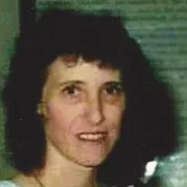
Linda K Blake Whittle
| Birth | : | 29 Jan 1946 Pleasant Hill, Cass County, Missouri, USA |
| Death | : | 30 Dec 2018 California, Moniteau County, Missouri, USA |
| Burial | : | Enloe Cemetery, Moniteau County, USA |
| Coordinate | : | 38.5074997, -92.4741974 |
| Description | : | Linda K. Whittle, age 72, of Russellville, MO, passed away the evening of December 30, 2018 at Moniteau Care Center, California, MO. She was born January 29, 1946, in Pleasant Hill, MO, the daughter of Royal Jack and Kathryn (Hand) Blake, both of whom preceded her in death. Linda attended Pleasant Hill High School. Linda was united in marriage to October 1, 1965 in Pleasant Hill, MO to Ronald Ray Whittle, who also preceded her in death. She worked for the State of Missouri as account clerk for Central Missouri Correctional Center (Church Farm) until her retirement. Linda was a... Read More |
frequently asked questions (FAQ):
-
Where is Linda K Blake Whittle's memorial?
Linda K Blake Whittle's memorial is located at: Enloe Cemetery, Moniteau County, USA.
-
When did Linda K Blake Whittle death?
Linda K Blake Whittle death on 30 Dec 2018 in California, Moniteau County, Missouri, USA
-
Where are the coordinates of the Linda K Blake Whittle's memorial?
Latitude: 38.5074997
Longitude: -92.4741974
Family Members:
Parent
Spouse

Flowers:


Nearby Cemetories:
1. Enloe Cemetery
Moniteau County, USA
Coordinate: 38.5074997, -92.4741974
2. Belleville Cemetery
Russellville, Cole County, USA
Coordinate: 38.4970490, -92.4667150
3. Enon Cemetery
Russellville, Cole County, USA
Coordinate: 38.4888992, -92.4730988
4. Karnes-Carney-Henderson Cemetery
Burris Fork, Moniteau County, USA
Coordinate: 38.4992100, -92.5007510
5. Saint Michael Cemetery
Russellville, Cole County, USA
Coordinate: 38.5109300, -92.4429100
6. Evangelical Lutheran Cemetery One Acre
Russellville, Cole County, USA
Coordinate: 38.5175667, -92.4415817
7. Buckner Russell Cemetery
Cole County, USA
Coordinate: 38.5136900, -92.4359390
8. Van Pool Cemetery
Moniteau County, USA
Coordinate: 38.5372009, -92.4627991
9. Russellville Cemetery
Russellville, Cole County, USA
Coordinate: 38.5196991, -92.4366989
10. Trinity Lutheran Cemetery
Russellville, Cole County, USA
Coordinate: 38.5028000, -92.4317017
11. Karnes Cemetery
Corticelli, Moniteau County, USA
Coordinate: 38.5099700, -92.5247900
12. Campbell Cemetery
Cole County, USA
Coordinate: 38.4810982, -92.4297028
13. Blank Cemetery
Russellville, Cole County, USA
Coordinate: 38.5203018, -92.4180984
14. DeFoe Cemetery
California, Moniteau County, USA
Coordinate: 38.5416985, -92.5250015
15. Rock Enon Cemetery
Miller County, USA
Coordinate: 38.4668400, -92.5170700
16. Bruce-Lewis-McGahan Cemetery
Enon, Moniteau County, USA
Coordinate: 38.4667500, -92.5172100
17. Roark Cemetery
Russellville, Cole County, USA
Coordinate: 38.4696999, -92.4255981
18. Matheis Cemetery
Russellville, Cole County, USA
Coordinate: 38.4571800, -92.4491600
19. Barnhardt Cemetery
Lohman, Cole County, USA
Coordinate: 38.5537900, -92.4267100
20. Clibourn Cemetery
Russellville, Cole County, USA
Coordinate: 38.4760500, -92.3973500
21. Marney Family Cemetery
High Point, Moniteau County, USA
Coordinate: 38.5357900, -92.5614500
22. Jackson Chapel Methodist Church Cemetery
California, Moniteau County, USA
Coordinate: 38.4447900, -92.5286500
23. Yarnell Cemetery
California, Moniteau County, USA
Coordinate: 38.5189018, -92.5708008
24. Gray Cemetery
Moniteau County, USA
Coordinate: 38.4536018, -92.5456009