
| Birth | : | 3 May 1935 Iberia, Miller County, Missouri, USA |
| Death | : | 21 Apr 2015 Mexico, Audrain County, Missouri, USA |
| Burial | : | Enloe Cemetery, Moniteau County, USA |
| Coordinate | : | 38.5074997, -92.4741974 |
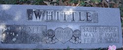
| Description | : | Ronald Ray Whittle, age 79, of California, MO, passed away the morning of Tuesday, April 21, 2015, at Missouri Veterans Home, Mexico, MO. He was born May 3, 1935, in Iberia, MO, the son of Clarence and Sadie (Houser) Whittle, both of whom preceded him in death. He attended School of the Osage and graduated with a Bachelor of Arts degree from Columbia College. Ronald was employed as a Chief Warrant Officer 4 for the Missouri Army National Guard and as a supervisor for State of Missouri Veterans Services. He retired from the military with over 37 years of total... Read More |
frequently asked questions (FAQ):
-
Where is Ronald Ray Whittle's memorial?
Ronald Ray Whittle's memorial is located at: Enloe Cemetery, Moniteau County, USA.
-
When did Ronald Ray Whittle death?
Ronald Ray Whittle death on 21 Apr 2015 in Mexico, Audrain County, Missouri, USA
-
Where are the coordinates of the Ronald Ray Whittle's memorial?
Latitude: 38.5074997
Longitude: -92.4741974
Family Members:
Parent

Spouse
Siblings


Nearby Cemetories:
1. Enloe Cemetery
Moniteau County, USA
Coordinate: 38.5074997, -92.4741974
2. Belleville Cemetery
Russellville, Cole County, USA
Coordinate: 38.4970490, -92.4667150
3. Enon Cemetery
Russellville, Cole County, USA
Coordinate: 38.4888992, -92.4730988
4. Karnes-Carney-Henderson Cemetery
Burris Fork, Moniteau County, USA
Coordinate: 38.4992100, -92.5007510
5. Saint Michael Cemetery
Russellville, Cole County, USA
Coordinate: 38.5109300, -92.4429100
6. Evangelical Lutheran Cemetery One Acre
Russellville, Cole County, USA
Coordinate: 38.5175667, -92.4415817
7. Buckner Russell Cemetery
Cole County, USA
Coordinate: 38.5136900, -92.4359390
8. Van Pool Cemetery
Moniteau County, USA
Coordinate: 38.5372009, -92.4627991
9. Russellville Cemetery
Russellville, Cole County, USA
Coordinate: 38.5196991, -92.4366989
10. Trinity Lutheran Cemetery
Russellville, Cole County, USA
Coordinate: 38.5028000, -92.4317017
11. Karnes Cemetery
Corticelli, Moniteau County, USA
Coordinate: 38.5099700, -92.5247900
12. Campbell Cemetery
Cole County, USA
Coordinate: 38.4810982, -92.4297028
13. Blank Cemetery
Russellville, Cole County, USA
Coordinate: 38.5203018, -92.4180984
14. DeFoe Cemetery
California, Moniteau County, USA
Coordinate: 38.5416985, -92.5250015
15. Rock Enon Cemetery
Miller County, USA
Coordinate: 38.4668400, -92.5170700
16. Bruce-Lewis-McGahan Cemetery
Enon, Moniteau County, USA
Coordinate: 38.4667500, -92.5172100
17. Roark Cemetery
Russellville, Cole County, USA
Coordinate: 38.4696999, -92.4255981
18. Matheis Cemetery
Russellville, Cole County, USA
Coordinate: 38.4571800, -92.4491600
19. Barnhardt Cemetery
Lohman, Cole County, USA
Coordinate: 38.5537900, -92.4267100
20. Clibourn Cemetery
Russellville, Cole County, USA
Coordinate: 38.4760500, -92.3973500
21. Marney Family Cemetery
High Point, Moniteau County, USA
Coordinate: 38.5357900, -92.5614500
22. Jackson Chapel Methodist Church Cemetery
California, Moniteau County, USA
Coordinate: 38.4447900, -92.5286500
23. Yarnell Cemetery
California, Moniteau County, USA
Coordinate: 38.5189018, -92.5708008
24. Gray Cemetery
Moniteau County, USA
Coordinate: 38.4536018, -92.5456009