
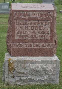

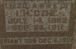
Lizzie A Trainer Coe
| Birth | : | 14 Jul 1862 Washington County, Indiana, USA |
| Death | : | 28 Sep 1911 Washington County, Indiana, USA |
| Burial | : | Holy Trinity Churchyard, Dalton, Northumberland Unitary Authority, England |
| Coordinate | : | 55.0423380, -1.8266440 |
| Description | : | Mrs. Coe burned to death while starting a fire with kerosene, September 28, 1911, in Jackson Township, Washington County. Burial was at Mt. Washington Cemetery. The above was submitted by Carl Robert Coe (#46623827) ~ ~ ~ ~ ~ |
frequently asked questions (FAQ):
-
Where is Lizzie A Trainer Coe's memorial?
Lizzie A Trainer Coe's memorial is located at: Holy Trinity Churchyard, Dalton, Northumberland Unitary Authority, England.
-
When did Lizzie A Trainer Coe death?
Lizzie A Trainer Coe death on 28 Sep 1911 in Washington County, Indiana, USA
-
Where are the coordinates of the Lizzie A Trainer Coe's memorial?
Latitude: 55.0423380
Longitude: -1.8266440
Family Members:
Parent
Spouse
Siblings

Children
Flowers:


Nearby Cemetories:
1. Holy Trinity Churchyard
Dalton, Northumberland Unitary Authority, England
Coordinate: 55.0423380, -1.8266440
2. Holy Saviour Churchyard
Milbourne, Northumberland Unitary Authority, England
Coordinate: 55.0699360, -1.8177890
3. Heddon on The Wall Churchyard
Heddon-on-the-Wall, Northumberland Unitary Authority, England
Coordinate: 54.9962960, -1.7923170
4. Belsay Woodland Burials
Belsay, Northumberland Unitary Authority, England
Coordinate: 55.0985470, -1.8388940
5. Holy Trinity Churchyard
Matfen, Northumberland Unitary Authority, England
Coordinate: 55.0403000, -1.9536100
6. Holy Cross Parish Churchyard
Ryton, Metropolitan Borough of Gateshead, England
Coordinate: 54.9774810, -1.7649850
7. St. Michael and All Angels Churchyard
Newburn, Metropolitan Borough of Newcastle upon Tyne, England
Coordinate: 54.9823080, -1.7410970
8. Ryton and Crawcrook Cemetery
Ryton, Metropolitan Borough of Gateshead, England
Coordinate: 54.9703360, -1.7596530
9. Tomb Garden, Harnham Hall
Belsay, Northumberland Unitary Authority, England
Coordinate: 55.1183970, -1.8862270
10. St. Matthew's Churchyard
Dinnington, Metropolitan Borough of Newcastle upon Tyne, England
Coordinate: 55.0533400, -1.6761000
11. Greenside Cemetery
Greenside, Metropolitan Borough of Gateshead, England
Coordinate: 54.9591900, -1.7808900
12. St. John's Churchyard
Greenside, Metropolitan Borough of Gateshead, England
Coordinate: 54.9584780, -1.7818970
13. Lemington Cemetery
Lemington, Metropolitan Borough of Newcastle upon Tyne, England
Coordinate: 54.9830640, -1.7121210
14. St Andrew Churchyard
Bolam, Northumberland Unitary Authority, England
Coordinate: 55.1376680, -1.8565600
15. St Bartholomew Churchyard
Kirkheaton, Northumberland Unitary Authority, England
Coordinate: 55.0902060, -1.9740250
16. St George's Churchyard
Mickley, Northumberland Unitary Authority, England
Coordinate: 54.9498300, -1.8831900
17. West Road Cemetery and Crematorium
Newcastle-upon-Tyne, Metropolitan Borough of Newcastle upon Tyne, England
Coordinate: 54.9835110, -1.6774750
18. Blaydon Cemetery
Blaydon, Metropolitan Borough of Gateshead, England
Coordinate: 54.9618300, -1.7079660
19. St Pauls Churchyard and Extension
Winlaton, Metropolitan Borough of Gateshead, England
Coordinate: 54.9513575, -1.7290585
20. St. John Churchyard
Meldon, Northumberland Unitary Authority, England
Coordinate: 55.1489650, -1.8144770
21. St Oswalds Churchyard
Halton, Northumberland Unitary Authority, England
Coordinate: 55.0050180, -2.0048830
22. St Andrew's Churchyard
Bywell, Northumberland Unitary Authority, England
Coordinate: 54.9482010, -1.9258340
23. St. Peter's Churchyard
Bywell, Northumberland Unitary Authority, England
Coordinate: 54.9476800, -1.9249700
24. Hazelrigg
Newcastle-upon-Tyne, Metropolitan Borough of Newcastle upon Tyne, England
Coordinate: 55.0410640, -1.6249120