
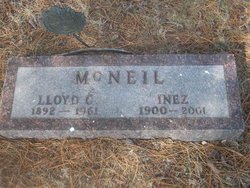
Lloyd Chapin “Mac” McNeil
| Birth | : | 31 Jul 1892 Roberts, Ford County, Illinois, USA |
| Death | : | 22 Oct 1961 Fort Pierre, Stanley County, South Dakota, USA |
| Burial | : | Scotty Philip Cemetery, Fort Pierre, Stanley County, USA |
| Coordinate | : | 44.4019012, -100.4036026 |
| Description | : | Lloyd Chapin was born in 1892 in Roberts, Ford County, Illinois. He later moved to Iowa and then Hettinger, North Dakota. He worked in Faith, South Dakota and moved to Pierre in 1930. He married Inez Barkley Laird Jan 21, 1944. Mac was a car salesman for Harding Motor Company in Pierre. Mac died in 1961 and was buried in Scotty Phillip Cemetery, Fort Pierre, South Dakota. |
frequently asked questions (FAQ):
-
Where is Lloyd Chapin “Mac” McNeil's memorial?
Lloyd Chapin “Mac” McNeil's memorial is located at: Scotty Philip Cemetery, Fort Pierre, Stanley County, USA.
-
When did Lloyd Chapin “Mac” McNeil death?
Lloyd Chapin “Mac” McNeil death on 22 Oct 1961 in Fort Pierre, Stanley County, South Dakota, USA
-
Where are the coordinates of the Lloyd Chapin “Mac” McNeil's memorial?
Latitude: 44.4019012
Longitude: -100.4036026
Family Members:
Spouse
Flowers:


Nearby Cemetories:
1. Scotty Philip Cemetery
Fort Pierre, Stanley County, USA
Coordinate: 44.4019012, -100.4036026
2. Fort Pierre Chouteau Cemetery
Fort Pierre, Stanley County, USA
Coordinate: 44.3908700, -100.3878300
3. Mount Calvary Cemetery
Pierre, Hughes County, USA
Coordinate: 44.4197006, -100.3557968
4. South Dakota State Capitol Grounds
Pierre, Hughes County, USA
Coordinate: 44.3660100, -100.3448000
5. Cedar Hill Cemetery
Fort Pierre, Stanley County, USA
Coordinate: 44.3356018, -100.3964005
6. Riverside Cemetery
Pierre, Hughes County, USA
Coordinate: 44.3608017, -100.3071976
7. Byron Township Cemetery
Blunt, Hughes County, USA
Coordinate: 44.4979200, -100.1904700
8. Fort Sully Post Cemetery
Sully County, USA
Coordinate: 44.5866480, -100.6087530
9. Meers Cemetery
Stanley County, USA
Coordinate: 44.4116970, -100.7360760
10. Mathews Family Cemetery
Stanley County, USA
Coordinate: 44.1816040, -100.5581080
11. Okobojo Cemetery
Sully County, USA
Coordinate: 44.6568985, -100.3647003
12. Canning Cemetery
Hughes County, USA
Coordinate: 44.3986890, -100.0278460
13. Holy Name Episcopal Cemetery
Fort Pierre, Stanley County, USA
Coordinate: 44.2694960, -100.0357300
14. Holy Name Chapel Cemetery
Fort Pierre, Stanley County, USA
Coordinate: 44.2694292, -100.0356989
15. Pleasant Hill Cemetery
Blunt, Hughes County, USA
Coordinate: 44.5135994, -100.0156021
16. Fort Bennett Post Cemetery
Stanley County, USA
Coordinate: 44.6716500, -100.6404200
17. Immanuel Lutheran Cemetery
Van Metre, Jones County, USA
Coordinate: 44.0958800, -100.7263300
18. Mission Ridge Cemetery
Mission Ridge, Stanley County, USA
Coordinate: 44.6960983, -100.7716980
19. Onida Cemetery
Onida, Sully County, USA
Coordinate: 44.7147000, -100.0650000
20. Chapelle Cemetery
Hughes County, USA
Coordinate: 44.3025017, -99.8653030
21. Holy Faith Cemetery
Lyman County, USA
Coordinate: 44.1356010, -99.9878006
22. Blair Cemetery
Sully County, USA
Coordinate: 44.8027992, -100.4199982
23. Sansarc Cemetery
Hayes, Stanley County, USA
Coordinate: 44.5153008, -101.0342026
24. Draper Cemetery
Draper, Jones County, USA
Coordinate: 43.9322014, -100.5475006