
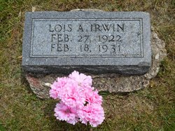
Lois Arlene Irwin
| Birth | : | 27 Feb 1922 West Liberty, Muscatine County, Iowa, USA |
| Death | : | 18 Feb 1931 West Liberty, Muscatine County, Iowa, USA |
| Burial | : | Soledad Cemetery, Soledad, Monterey County, USA |
| Coordinate | : | 36.4275131, -121.3124542 |
| Plot | : | Row 4, Lot 6, Space 1 |
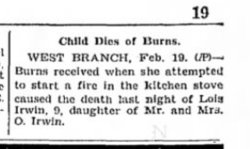
| Description | : | Obituary: Lois Arlene Irwin, nine-year-old daughter of Mr. and Mrs. Oliver Irwin, was fatally burned at her tome four miles east of West Branch Wednesday afternoon at 4:15 o'clock. The little girl came home from school and finding her parents away endeavored to start a fire In the coal range in the kitchen. She poured kerosene on the hot coals and while holding the can over the spurts of flame the kerosene caught fire. She dropped the can and the linoleum on the floor caught fire. Fifteen minutes later Mrs. Irwin returned to find the little girl in... Read More |
frequently asked questions (FAQ):
-
Where is Lois Arlene Irwin's memorial?
Lois Arlene Irwin's memorial is located at: Soledad Cemetery, Soledad, Monterey County, USA.
-
When did Lois Arlene Irwin death?
Lois Arlene Irwin death on 18 Feb 1931 in West Liberty, Muscatine County, Iowa, USA
-
Where are the coordinates of the Lois Arlene Irwin's memorial?
Latitude: 36.4275131
Longitude: -121.3124542
Family Members:
Parent
Siblings

Flowers:


Nearby Cemetories:
1. Soledad Cemetery
Soledad, Monterey County, USA
Coordinate: 36.4275131, -121.3124542
2. Soledad Mission Cemetery
Soledad, Monterey County, USA
Coordinate: 36.4047460, -121.3561260
3. San Benito County Cemetery
Hollister, San Benito County, USA
Coordinate: 36.4859009, -121.2306976
4. Gonzales Cemetery
Gonzales, Monterey County, USA
Coordinate: 36.4947014, -121.4300003
5. Greenfield Cemetery
Greenfield, Monterey County, USA
Coordinate: 36.3347130, -121.2128372
6. Greenfield Holy Trinity Cemetery
Greenfield, Monterey County, USA
Coordinate: 36.3164139, -121.2428131
7. Willow Creek Cemetery
San Benito County, USA
Coordinate: 36.5957985, -121.1903000
8. Bitterwater Cemetery
Rock Spring Peak, San Benito County, USA
Coordinate: 36.4006004, -120.9916992
9. King City Cemetery
King City, Monterey County, USA
Coordinate: 36.2066078, -121.1374207
10. Paicines Cemetery
Paicines, San Benito County, USA
Coordinate: 36.7088580, -121.2456330
11. Cherry Hill Cemetery
Panoche, San Benito County, USA
Coordinate: 36.6150017, -120.9586029
12. Yamato Cemetery
Salinas, Monterey County, USA
Coordinate: 36.6552811, -121.6307297
13. Garden of Memories
Salinas, Monterey County, USA
Coordinate: 36.6565247, -121.6384125
14. Mansfield Cemetery
King City, Monterey County, USA
Coordinate: 36.1030320, -121.1478060
15. Church of the Good Shepherd Cemetery
Salinas, Monterey County, USA
Coordinate: 36.5413990, -121.7260410
16. Saint Pauls Episcopal Church Columbarium
Salinas, Monterey County, USA
Coordinate: 36.6588430, -121.6558850
17. Chinese Cemetery
Salinas, Monterey County, USA
Coordinate: 36.6952057, -121.6390381
18. Monterey County Potters Field Cemetery
Salinas, Monterey County, USA
Coordinate: 36.6960900, -121.6381950
19. Barbree Ranch Cemetery
San Lucas, Monterey County, USA
Coordinate: 36.0914030, -121.0822670
20. Saint Georges Episcopal Church Columbarium
Salinas, Monterey County, USA
Coordinate: 36.7062580, -121.6440980
21. San Lucas Cemetery
San Lucas, Monterey County, USA
Coordinate: 36.1258354, -121.0134735
22. Calvary Catholic Cemetery
Salinas, Monterey County, USA
Coordinate: 36.6880341, -121.6818085
23. Long Valley Cemetery
San Lucas, Monterey County, USA
Coordinate: 36.1467700, -120.9545100
24. Whitcher Cemetery
East Garrison, Monterey County, USA
Coordinate: 36.6501730, -121.7305270