
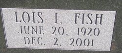
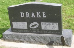
Lois Irene Fish Drake
| Birth | : | 20 Jun 1920 Newton, Jasper County, Iowa, USA |
| Death | : | 2 Dec 2001 Webster City, Hamilton County, Iowa, USA |
| Burial | : | St Cuthbert Churchyard, Haydon Bridge, Northumberland Unitary Authority, England |
| Coordinate | : | 54.9740620, -2.2473570 |
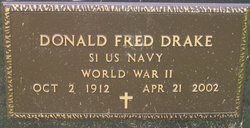
| Description | : | Mrs. Lois Irene Drake, 81, of Stratford, IA, died Sunday, December 02, 2001, at Hamilton County Public Hospital, Webster City, IA. She and her husband Donald Drake are former Brooklyn, IA, residents. Funeral services were held at 2 PM Wednesday, December 5, 2001, at the Nevenhoven Funeral Home, Brooklyn, with burial in the Kent Cemetery. Rev. Rod Rindahl, Pastor of Evangelical Bible Church of Pilot Mound, officiated. The organist was Marilyn Kriegel. Casket-bearers were Danny Drake, Daryl Drake, Robert Drake, Roger Drake, Richard Drake and Mike Kelly. Lois Irene Fish Drake, daughter of William Cloyd Fish and Jessie Atwater Fish,... Read More |
frequently asked questions (FAQ):
-
Where is Lois Irene Fish Drake's memorial?
Lois Irene Fish Drake's memorial is located at: St Cuthbert Churchyard, Haydon Bridge, Northumberland Unitary Authority, England.
-
When did Lois Irene Fish Drake death?
Lois Irene Fish Drake death on 2 Dec 2001 in Webster City, Hamilton County, Iowa, USA
-
Where are the coordinates of the Lois Irene Fish Drake's memorial?
Latitude: 54.9740620
Longitude: -2.2473570
Family Members:
Spouse
Children
Flowers:


Nearby Cemetories:
1. St Cuthbert Churchyard
Haydon Bridge, Northumberland Unitary Authority, England
Coordinate: 54.9740620, -2.2473570
2. Haydon Bridge Churchyard Extension
Haydon Bridge, Northumberland Unitary Authority, England
Coordinate: 54.9766250, -2.2478820
3. Haydon Bridge Cemetery
Haydon Bridge, Northumberland Unitary Authority, England
Coordinate: 54.9694700, -2.2467715
4. Haydon Old Churchyard
Haydon Bridge, Northumberland Unitary Authority, England
Coordinate: 54.9818710, -2.2483010
5. St. Cuthbert's Churchyard
Beltingham, Northumberland Unitary Authority, England
Coordinate: 54.9694330, -2.3305080
6. Beltingham Cemetery
Beltingham, Northumberland Unitary Authority, England
Coordinate: 54.9690700, -2.3312200
7. St Andrew's Cemetery
Haydon Bridge, Northumberland Unitary Authority, England
Coordinate: 54.9788680, -2.1276850
8. Hexham Cemetery
Hexham, Northumberland Unitary Authority, England
Coordinate: 54.9788580, -2.1276740
9. All Hallows Churchyard
Henshaw, Northumberland Unitary Authority, England
Coordinate: 54.9731030, -2.3704408
10. St. Cuthbert's Churchyard
Allendale, Northumberland Unitary Authority, England
Coordinate: 54.8978260, -2.2545020
11. Keenley Methodist Chapel Graveyard
Allendale, Northumberland Unitary Authority, England
Coordinate: 54.9053170, -2.3075580
12. Friends Meeting House
Allendale, Northumberland Unitary Authority, England
Coordinate: 54.8957750, -2.2598490
13. Allendale Old Cemetery
Allendale, Northumberland Unitary Authority, England
Coordinate: 54.8941650, -2.2612690
14. Allendale Woodland Cemetery
Allendale, Northumberland Unitary Authority, England
Coordinate: 54.8932624, -2.2618136
15. St John of Beverley Churchyard
Acomb, Northumberland Unitary Authority, England
Coordinate: 54.9859680, -2.1061560
16. St John Lee, St John of Beverley Old Churchyard
Hexham, Northumberland Unitary Authority, England
Coordinate: 54.9860620, -2.1056870
17. St Mary Roman Catholic Churchyard
Hexham, Northumberland Unitary Authority, England
Coordinate: 54.9697070, -2.1040520
18. St. John Lee of Beverley New Churchyard
Acomb, Northumberland Unitary Authority, England
Coordinate: 54.9861290, -2.1049280
19. Hexham Abbey
Hexham, Northumberland Unitary Authority, England
Coordinate: 54.9715940, -2.1026190
20. St Peter's Churchyard
Humshaugh, Northumberland Unitary Authority, England
Coordinate: 55.0368780, -2.1264880
21. High House Methodist Chapel Graveyard
Allendale, Northumberland Unitary Authority, England
Coordinate: 54.8844090, -2.3285218
22. St Giles Churchyard
Chollerton, Northumberland Unitary Authority, England
Coordinate: 55.0414100, -2.1094900
23. Cowburn Primitive Methodist Chapel
Cowburn, Northumberland Unitary Authority, England
Coordinate: 55.0034880, -2.4323380
24. Dilston Castle Chapelyard
Corbridge, Northumberland Unitary Authority, England
Coordinate: 54.9639270, -2.0393460