
| Memorials | : | 1 |
| Location | : | Cowburn, Northumberland Unitary Authority, England |
| Coordinate | : | 55.0034880, -2.4323380 |
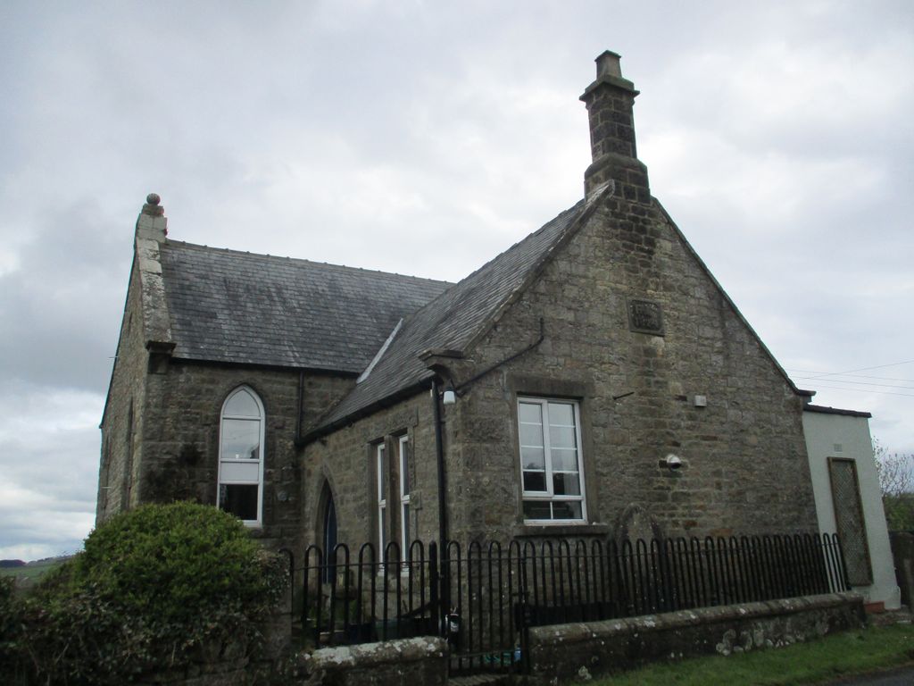
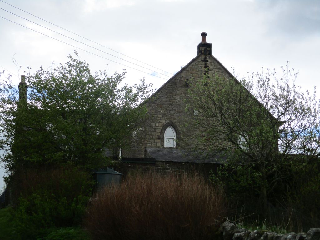
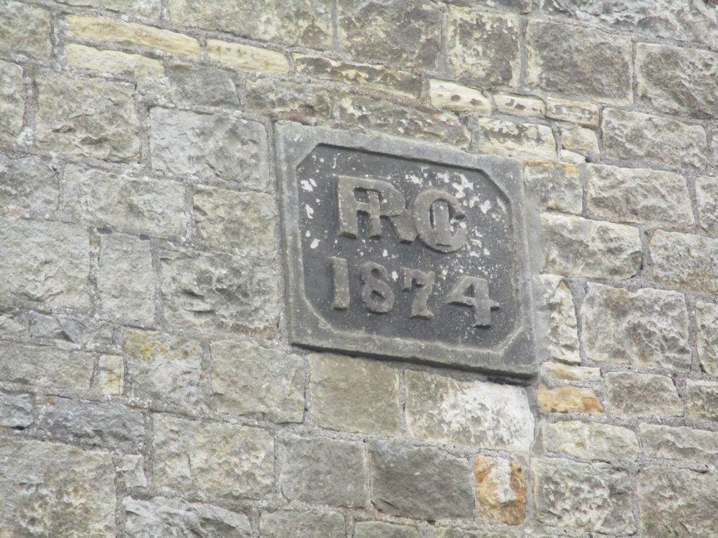
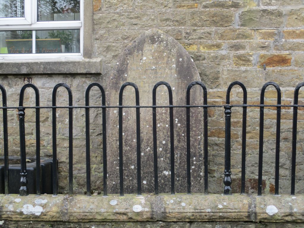
| Description | : | This former Methodist church was built in 1874. It has a chapel and schoolroom, but is now converted to a private house. Cowburn is a remote community. Unsure how many graves there are, but one was propped up against the front wall of the chapel. |
frequently asked questions (FAQ):
-
Where is Cowburn Primitive Methodist Chapel?
Cowburn Primitive Methodist Chapel is located at Cowburn near Melkridge Cowburn, Northumberland Unitary Authority ,Northumberland , NE49 9PLEngland.
-
Cowburn Primitive Methodist Chapel cemetery's updated grave count on graveviews.com?
0 memorials
-
Where are the coordinates of the Cowburn Primitive Methodist Chapel?
Latitude: 55.0034880
Longitude: -2.4323380
Nearby Cemetories:
1. Holy Cross Churchyard
Haltwhistle, Northumberland Unitary Authority, England
Coordinate: 54.9699900, -2.4583480
2. Haltwhistle Cemetery
Haltwhistle, Northumberland Unitary Authority, England
Coordinate: 54.9652600, -2.4740100
3. All Hallows Churchyard
Henshaw, Northumberland Unitary Authority, England
Coordinate: 54.9731030, -2.3704408
4. St Cuthbert's Churchyard
Greenhead, Northumberland Unitary Authority, England
Coordinate: 54.9813930, -2.5324120
5. Beltingham Cemetery
Beltingham, Northumberland Unitary Authority, England
Coordinate: 54.9690700, -2.3312200
6. St. Cuthbert's Churchyard
Beltingham, Northumberland Unitary Authority, England
Coordinate: 54.9694330, -2.3305080
7. Friends Meeting House Cemetery
Coanwood, Northumberland Unitary Authority, England
Coordinate: 54.9241920, -2.4540450
8. St Mary Magdalene Churchyard
Gilsland, Northumberland Unitary Authority, England
Coordinate: 54.9989150, -2.5743860
9. St Mary & St Patrick Churchyard
Lambley, Northumberland Unitary Authority, England
Coordinate: 54.9209060, -2.5122140
10. Haydon Old Churchyard
Haydon Bridge, Northumberland Unitary Authority, England
Coordinate: 54.9818710, -2.2483010
11. Haydon Bridge Churchyard Extension
Haydon Bridge, Northumberland Unitary Authority, England
Coordinate: 54.9766250, -2.2478820
12. St Cuthbert Churchyard
Haydon Bridge, Northumberland Unitary Authority, England
Coordinate: 54.9740620, -2.2473570
13. Haydon Bridge Cemetery
Haydon Bridge, Northumberland Unitary Authority, England
Coordinate: 54.9694700, -2.2467715
14. St Cuthbert's Churchyard
Nether Denton, City of Carlisle, England
Coordinate: 54.9743370, -2.6340210
15. Keenley Methodist Chapel Graveyard
Allendale, Northumberland Unitary Authority, England
Coordinate: 54.9053170, -2.3075580
16. St Jude's Churchyard
Knarsdale, Northumberland Unitary Authority, England
Coordinate: 54.8817960, -2.5024290
17. High House Methodist Chapel Graveyard
Allendale, Northumberland Unitary Authority, England
Coordinate: 54.8844090, -2.3285218
18. Friends Meeting House
Allendale, Northumberland Unitary Authority, England
Coordinate: 54.8957750, -2.2598490
19. St. Cuthbert's Churchyard
Allendale, Northumberland Unitary Authority, England
Coordinate: 54.8978260, -2.2545020
20. Allendale Old Cemetery
Allendale, Northumberland Unitary Authority, England
Coordinate: 54.8941650, -2.2612690
21. Allendale Woodland Cemetery
Allendale, Northumberland Unitary Authority, England
Coordinate: 54.8932624, -2.2618136
22. St. Cuthbert's Churchyard
Bewcastle, City of Carlisle, England
Coordinate: 55.0635980, -2.6821690
23. Lanercost Priory
Lanercost, City of Carlisle, England
Coordinate: 54.9659840, -2.6954990
24. St Thomas a Becket
Farlam, City of Carlisle, England
Coordinate: 54.9319760, -2.6751970