

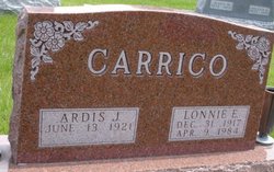
Lonnie Eugene “Red” Carrico
| Birth | : | 31 Dec 1917 Bethany, Clay County, Missouri, USA |
| Death | : | 9 Apr 1984 Redfield, Dallas County, Iowa, USA |
| Burial | : | Calvary Cemetery, La Junta, Otero County, USA |
| Coordinate | : | 37.9832000, -103.5622000 |
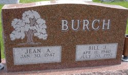
| Description | : | Lonnie (Red) Carrico, 66, of Redfield died April 9. He was born Dec. 31, 1917 in Harrison County, Mo. to Lloyd and Zada Carrico and married Ardis Paardekooper on Jan. 8, 1941. He lived most of his life in Redfield. Mr. Carrico was a farmer, a veteran of World War II and a member of the Redfield American Legion post. He was preceded in death by his parents. Survivors include his wife; two sons, Jerry of Redfield and Jim of Adel; a daughter, Jean Burch of Runnells; his step-mother, Lucille Carrico of Perry; two sisters, Thelma Gilson of Ridgeway, Mo. and Emily Maelusi of... Read More |
frequently asked questions (FAQ):
-
Where is Lonnie Eugene “Red” Carrico's memorial?
Lonnie Eugene “Red” Carrico's memorial is located at: Calvary Cemetery, La Junta, Otero County, USA.
-
When did Lonnie Eugene “Red” Carrico death?
Lonnie Eugene “Red” Carrico death on 9 Apr 1984 in Redfield, Dallas County, Iowa, USA
-
Where are the coordinates of the Lonnie Eugene “Red” Carrico's memorial?
Latitude: 37.9832000
Longitude: -103.5622000
Family Members:
Parent

Spouse
Siblings
Children
Flowers:


Nearby Cemetories:
1. Calvary Cemetery
La Junta, Otero County, USA
Coordinate: 37.9832000, -103.5622000
2. Fairview Cemetery
La Junta, Otero County, USA
Coordinate: 37.9873000, -103.5607000
3. Saint Andrews Episcopal Church Columbarium
La Junta, Otero County, USA
Coordinate: 37.9809000, -103.5455000
4. Ormega Cemetery
La Junta, Otero County, USA
Coordinate: 37.9684000, -103.5770000
5. Saint Paul’s Lutheran Cemetery
Otero County, USA
Coordinate: 38.0342000, -103.4542000
6. Holbrook Cemetery
Otero County, USA
Coordinate: 38.0842018, -103.5432968
7. Bents Old Fort Cemetery
La Junta, Otero County, USA
Coordinate: 38.0416000, -103.4297000
8. Hillcrest Cemetery
Rocky Ford, Otero County, USA
Coordinate: 38.0388985, -103.7071991
9. Valley View Cemetery
Rocky Ford, Otero County, USA
Coordinate: 38.0388985, -103.7093964
10. East Holbrook Mennonite Cemetery
Cheraw, Otero County, USA
Coordinate: 38.1101837, -103.4729767
11. Higbee Cemetery
Higbee, Otero County, USA
Coordinate: 37.7630997, -103.4555969
12. Timpas Cemetery
Timpas, Otero County, USA
Coordinate: 37.8081000, -103.7681000
13. Martinez Cemetery
Otero County, USA
Coordinate: 37.7303009, -103.5002975
14. Lakeview Cemetery
Sugar City, Crowley County, USA
Coordinate: 38.2332993, -103.6725006
15. Manzanola Mountainview Cemetery
Manzanola, Otero County, USA
Coordinate: 38.0900002, -103.8764038
16. Las Animas Cemetery
Las Animas, Bent County, USA
Coordinate: 38.0424995, -103.2174988
17. Boggsville National Historic Site Grounds
Boggsville, Bent County, USA
Coordinate: 38.0425130, -103.2102730
18. Valley View Cemetery
Ordway, Crowley County, USA
Coordinate: 38.2546997, -103.7489014
19. Olney Springs Cemetery
Olney Springs, Crowley County, USA
Coordinate: 38.1472282, -103.9310684
20. Pruett Cemetery
Bent County, USA
Coordinate: 37.7172012, -103.2897034
21. Dolores Mission Cemetery
Kim, Las Animas County, USA
Coordinate: 37.6365200, -103.5854900
22. Barnard Burial Site
Elder, Otero County, USA
Coordinate: 38.1235554, -103.9665095
23. Fort Lyon National Cemetery
Fort Lyon, Bent County, USA
Coordinate: 38.0847015, -103.1288986
24. Arlington Cemetery
Arlington, Kiowa County, USA
Coordinate: 38.3232994, -103.3597031