
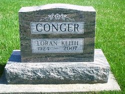
Loran "Keith" Conger
| Birth | : | 14 Aug 1924 Mendota, Putnam County, Missouri, USA |
| Death | : | 30 Nov 2007 Exline, Appanoose County, Iowa, USA |
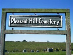
| Burial | : | Hāwera Cemetery, Hāwera, South Taranaki District, New Zealand |
| Coordinate | : | -39.5897900, 174.2945500 |
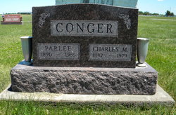
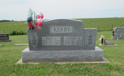
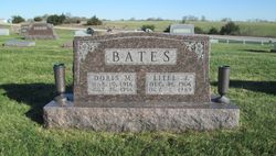
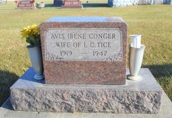
| Description | : | Loran "Keith" Conger, age 83, died Friday, November 30, 2007 at his home near Exline, Iowa. He was born near Mendota, Missouri, the son of Charles M. and Clittie Parlee(Mikels)Conger on August 14, 1924. He attended the Mayflower School south of Cincinnati, Iowa. Due to a prolonged illness, he was not able to attend high school and sinece 1940, lived with his parents on their Century Farm, south of Exline, until their deaths and the remainder of his life. Keith was preceded in death by his parents; four sisters, Esther Kerby, Bernice Campbell, Doris Bates, and Avis Tice;... Read More |
frequently asked questions (FAQ):
-
Where is Loran "Keith" Conger's memorial?
Loran "Keith" Conger's memorial is located at: Hāwera Cemetery, Hāwera, South Taranaki District, New Zealand.
-
When did Loran "Keith" Conger death?
Loran "Keith" Conger death on 30 Nov 2007 in Exline, Appanoose County, Iowa, USA
-
Where are the coordinates of the Loran "Keith" Conger's memorial?
Latitude: -39.5897900
Longitude: 174.2945500
Family Members:
Parent
Siblings


Flowers:


Nearby Cemetories:
1. Hāwera Cemetery
Hāwera, South Taranaki District, New Zealand
Coordinate: -39.5897900, 174.2945500
2. Tiwhaiti Urupa (Taiporohenui Marae)
Hāwera, South Taranaki District, New Zealand
Coordinate: -39.5741843, 174.3216120
3. Waihi Cemetery and Redoubt
Normanby, South Taranaki District, New Zealand
Coordinate: -39.5444930, 174.2566820
4. Te Utinga Urupā
Normanby, South Taranaki District, New Zealand
Coordinate: -39.5330847, 174.2761055
5. Ohawe Military Cemetery
Ohawe Beach, South Taranaki District, New Zealand
Coordinate: -39.5835138, 174.2003758
6. Weri Weri Urupa Aotearoa Marae
Okaiawa, South Taranaki District, New Zealand
Coordinate: -39.5190700, 174.2206700
7. Okaiawa Cemetery
Okaiawa, South Taranaki District, New Zealand
Coordinate: -39.5310220, 174.2042180
8. Manutahi Cemetery
Manutahi, South Taranaki District, New Zealand
Coordinate: -39.6594677, 174.3924181
9. Manaia Cemetery
Manaia, South Taranaki District, New Zealand
Coordinate: -39.5575010, 174.1354470
10. Motuawa Urupā Waiokura Marae
Manaia, South Taranaki District, New Zealand
Coordinate: -39.5388010, 174.1438990
11. Manaia Redoubt
Manaia, South Taranaki District, New Zealand
Coordinate: -39.5461557, 174.1364306
12. Te Ngutu o te Manu Battlesite Memorial
Kapuni, South Taranaki District, New Zealand
Coordinate: -39.4876351, 174.1838147
13. Eltham Cemetery
Eltham, South Taranaki District, New Zealand
Coordinate: -39.4197140, 174.3251260
14. Kaponga Cemetery
Kaponga, South Taranaki District, New Zealand
Coordinate: -39.4312210, 174.1553160
15. Patea General Cemetery
Patea, South Taranaki District, New Zealand
Coordinate: -39.7447980, 174.4685340
16. Otakeho Cemetery
New Plymouth, New Plymouth District, New Zealand
Coordinate: -39.5492080, 174.0051880
17. Pioneer Cemetery
Stratford, Stratford District, New Zealand
Coordinate: -39.3359800, 174.2929000
18. Kopuatama Cemetery
Stratford, Stratford District, New Zealand
Coordinate: -39.3364400, 174.3364500
19. Pihama Cemetery
Pihama, South Taranaki District, New Zealand
Coordinate: -39.5075300, 173.9285600
20. Midhirst Cemetery
Midhirst, Stratford District, New Zealand
Coordinate: -39.2913640, 174.2724620
21. Midhirst Old Cemetery
Midhirst, Stratford District, New Zealand
Coordinate: -39.2911920, 174.2731980
22. Waverley Cemetery
Waverley, South Taranaki District, New Zealand
Coordinate: -39.7675900, 174.6292700
23. Opunake Cemetery
Opunake, South Taranaki District, New Zealand
Coordinate: -39.4515370, 173.8458110
24. Inglewood Cemetery
Inglewood, New Plymouth District, New Zealand
Coordinate: -39.1554140, 174.2145930