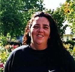
Lori LaMae Sanders Canaday
| Birth | : | 24 Sep 1961 Wichita, Sedgwick County, Kansas, USA |
| Death | : | 13 Jun 2020 Protection, Comanche County, Kansas, USA |
| Burial | : | Protection Cemetery, Protection, Comanche County, USA |
| Coordinate | : | 37.2125015, -99.4946976 |
| Description | : | Lori LaMae Canaday, 58, passed away Saturday, June 13, 2020, at her residence in Protection, KS. Born September 24, 1961, at Wichita, KS, she was the daughter of Billy Jack and Patricia Ann (Myers) Sanders. Lori was a resident of Protection, KS, previously living in Vernon Co., MO. She attended Protection Grade School, graduated from Protection High School in 1979, and attended Northwestern Oklahoma State University in Alva, OK. She worked as a dispatcher for Vernon Co., MO and Clark Co., KS. On November 9, 1995, she married Danny Canaday at Nevada, MO. He... Read More |
frequently asked questions (FAQ):
-
Where is Lori LaMae Sanders Canaday's memorial?
Lori LaMae Sanders Canaday's memorial is located at: Protection Cemetery, Protection, Comanche County, USA.
-
When did Lori LaMae Sanders Canaday death?
Lori LaMae Sanders Canaday death on 13 Jun 2020 in Protection, Comanche County, Kansas, USA
-
Where are the coordinates of the Lori LaMae Sanders Canaday's memorial?
Latitude: 37.2125015
Longitude: -99.4946976
Family Members:
Parent
Flowers:
Nearby Cemetories:
1. Protection Cemetery
Protection, Comanche County, USA
Coordinate: 37.2125015, -99.4946976
2. Protection Mennonite Cemetery
Protection, Comanche County, USA
Coordinate: 37.1188640, -99.4790610
3. Lexington Cemetery
Lexington, Clark County, USA
Coordinate: 37.3231010, -99.5841980
4. Willie Darrow Gravesite
Comanche County, USA
Coordinate: 37.2403230, -99.3280850
5. Avilla Cemetery
Protection, Comanche County, USA
Coordinate: 37.1272011, -99.3507996
6. Crown Hill Cemetery
Coldwater, Comanche County, USA
Coordinate: 37.2708015, -99.2944031
7. Highland Cemetery
Ashland, Clark County, USA
Coordinate: 37.1983700, -99.7474900
8. Saint Josephs Cemetery
Ashland, Clark County, USA
Coordinate: 37.1991997, -99.7485962
9. Nescatunga Cemetery
Comanche County, USA
Coordinate: 37.2296982, -99.2397003
10. Snake Creek Ranch Cemetery
Ashland, Clark County, USA
Coordinate: 37.0017700, -99.6458200
11. Willow Creek Cemetery
Buffalo, Harper County, USA
Coordinate: 36.9688988, -99.5749969
12. Wilmore Cemetery
Wilmore, Comanche County, USA
Coordinate: 37.3431015, -99.2097015
13. Coy Cemetery
Freedom, Woods County, USA
Coordinate: 36.9721700, -99.3029700
14. Willard Cemetery
Willard, Harper County, USA
Coordinate: 36.9585991, -99.7197037
15. Zion Lutheran Cemetery
Buffalo, Harper County, USA
Coordinate: 36.8999500, -99.4850900
16. Hopewell Cemetery
Harper County, USA
Coordinate: 36.8708000, -99.5164032
17. Bucklin Cemetery
Bucklin, Ford County, USA
Coordinate: 37.5428009, -99.6436005
18. Goldenrod Cemetery
Buffalo, Harper County, USA
Coordinate: 36.8555493, -99.5002693
19. Evansville Cemetery
Coldwater Township, Comanche County, USA
Coordinate: 37.1292629, -99.0584482
20. Otter Creek Cemetery
Buffalo, Harper County, USA
Coordinate: 36.8781100, -99.6581200
21. Lookout Cemetery
Freedom, Woods County, USA
Coordinate: 36.9002991, -99.2722015
22. Bethel Memorial Garden
Greensburg, Kiowa County, USA
Coordinate: 37.5578310, -99.3393690
23. Cowboy Cemetery
Woods County, USA
Coordinate: 36.9664001, -99.1492004
24. Sodville Cemetery
Ford County, USA
Coordinate: 37.5261002, -99.7508011


