

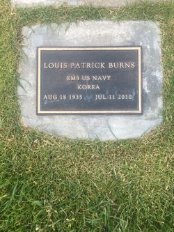

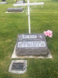
Louis P. “Lou” Burns
| Birth | : | 18 Aug 1935 Sioux City, Woodbury County, Iowa, USA |
| Death | : | 11 Jul 2010 Anaconda, Deer Lodge County, Montana, USA |
| Burial | : | St. James' Churchyard, Cameley, Bath and North East Somerset Unitary Authority, England |
| Coordinate | : | 51.3158560, -2.5606190 |
| Description | : | ANACONDA, MT - Louis "Lou" P. Burns, beloved husband, brother, step-father, uncle, and friend died peacefully Sunday, July 11, 2010, in Community Hospital of Anaconda, after his brave battle with renal cancer, with his loving wife, Shirley, by his side. Lou was born Aug. 18, 1935, to Mary and John Burns in Sioux City, Iowa, where he attended school before his three years in the Navy during the Korean War. After his honorable discharge, he worked on the microwave tower construction crew around the country. Lou then began his apprenticeship as a glazier in Reno, Nev. He spent time in California,... Read More |
frequently asked questions (FAQ):
-
Where is Louis P. “Lou” Burns's memorial?
Louis P. “Lou” Burns's memorial is located at: St. James' Churchyard, Cameley, Bath and North East Somerset Unitary Authority, England.
-
When did Louis P. “Lou” Burns death?
Louis P. “Lou” Burns death on 11 Jul 2010 in Anaconda, Deer Lodge County, Montana, USA
-
Where are the coordinates of the Louis P. “Lou” Burns's memorial?
Latitude: 51.3158560
Longitude: -2.5606190
Family Members:
Spouse
Flowers:


Nearby Cemetories:
1. St. James' Churchyard
Cameley, Bath and North East Somerset Unitary Authority, England
Coordinate: 51.3158560, -2.5606190
2. St Margarets Churchyard
Hinton Blewett, Bath and North East Somerset Unitary Authority, England
Coordinate: 51.3104000, -2.5834000
3. Saint Augustine of Hippo
Clutton, Bath and North East Somerset Unitary Authority, England
Coordinate: 51.3281990, -2.5430220
4. St Nicholas & the Blessed Virgin Mary
Stowey Sutton, Bath and North East Somerset Unitary Authority, England
Coordinate: 51.3329190, -2.5764850
5. St. John the Baptist Churchyard
Farrington Gurney, Bath and North East Somerset Unitary Authority, England
Coordinate: 51.2993710, -2.5248000
6. Bishop's Sutton Holy Trinity Churchyard
Bath and North East Somerset Unitary Authority, England
Coordinate: 51.3341900, -2.5958300
7. Saint Mary the Virgin Churchyard
Litton, Mendip District, England
Coordinate: 51.2899860, -2.5838440
8. Holy Trinity Churchyard
High Littleton, Bath and North East Somerset Unitary Authority, England
Coordinate: 51.3195810, -2.5115860
9. Church of the Holy Trinity
Paulton, Bath and North East Somerset Unitary Authority, England
Coordinate: 51.3074740, -2.5033500
10. Saint Mary the Virgin Church
Ston Easton, Mendip District, England
Coordinate: 51.2789610, -2.5407720
11. Paulton Cemetery
Paulton, Bath and North East Somerset Unitary Authority, England
Coordinate: 51.3095671, -2.4988841
12. St Mary The Virgin Churchyard
Ston Easton, Mendip District, England
Coordinate: 51.2788400, -2.5404390
13. Harptree Cemetery
East Harptree, Bath and North East Somerset Unitary Authority, England
Coordinate: 51.3056390, -2.6238890
14. St Mary Magdalene Churchyard
Chewton Mendip, Mendip District, England
Coordinate: 51.2760790, -2.5800490
15. Saint Laurence Churchyard
East Harptree, Bath and North East Somerset Unitary Authority, England
Coordinate: 51.3011730, -2.6245740
16. Saint Leonard Churchyard
Chelwood, Bath and North East Somerset Unitary Authority, England
Coordinate: 51.3546300, -2.5246880
17. St Mary the Virgin Churchyard
Stanton Drew, Bath and North East Somerset Unitary Authority, England
Coordinate: 51.3657390, -2.5788440
18. Blessed Virgin Mary Churchyard
Timsbury, Bath and North East Somerset Unitary Authority, England
Coordinate: 51.3257710, -2.4782750
19. St Mary Church Cemetery
Timsbury, Bath and North East Somerset Unitary Authority, England
Coordinate: 51.3268300, -2.4784070
20. All Saints Churchyard
Farmborough, Bath and North East Somerset Unitary Authority, England
Coordinate: 51.3430620, -2.4876590
21. Saint Thomas Churchyard
Pensford, Bath and North East Somerset Unitary Authority, England
Coordinate: 51.3710450, -2.5495820
22. St. John the Baptist Churchyard
Midsomer Norton, Bath and North East Somerset Unitary Authority, England
Coordinate: 51.2870310, -2.4842190
23. St. Mary the Virgin Churchyard
Emborough, Mendip District, England
Coordinate: 51.2600970, -2.5539150
24. St John the Baptist Church Cemetery
Chilcompton, Mendip District, England
Coordinate: 51.2693960, -2.5073780