
| Birth | : | 17 Aug 1921 Vinland, Douglas County, Kansas, USA |
| Death | : | 25 Dec 1983 Lawrence, Douglas County, Kansas, USA |
| Burial | : | Memorial Park Cemetery, Lawrence, Douglas County, USA |
| Coordinate | : | 38.9552994, -95.2153015 |
| Plot | : | Park Section A and Orchard Lawn |
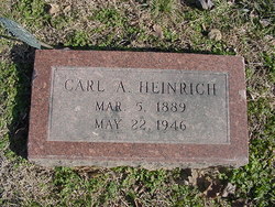
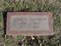
| Description | : | THE TOPEKA CAPITAL-JOURNAL Dec. 27, 1983 LAWRENCE--Louis W. Heinrich, 62, Lawrence, died Dec. 25, at a hospital here. Mr. Heinrich was in the floor covering business more than 30 years. He was born Aug. 17, 1921, at Vinland, the son of Carl August and Alma Fae Hoskinson Heinrich, and spent move of his life in Douglas County. He moved to Lawrence from Eudora in 1938. He served with the Army in Sicily, Italy and France during WW II. He was a member of the American Legion and Local No. 1179 of the Resilient Floor and Decorative Covering Workers Union, both at Lawrence.... Read More |
frequently asked questions (FAQ):
-
Where is Louis William Heinrich's memorial?
Louis William Heinrich's memorial is located at: Memorial Park Cemetery, Lawrence, Douglas County, USA.
-
When did Louis William Heinrich death?
Louis William Heinrich death on 25 Dec 1983 in Lawrence, Douglas County, Kansas, USA
-
Where are the coordinates of the Louis William Heinrich's memorial?
Latitude: 38.9552994
Longitude: -95.2153015
Family Members:
Parent
Spouse

Siblings
Children
Flowers:


Nearby Cemetories:
1. Memorial Park Cemetery
Lawrence, Douglas County, USA
Coordinate: 38.9552994, -95.2153015
2. Mount Calvary Catholic Cemetery
Lawrence, Douglas County, USA
Coordinate: 38.9580002, -95.2139969
3. Oak Hill Cemetery
Lawrence, Douglas County, USA
Coordinate: 38.9589005, -95.2118988
4. Trinity Episcopal Church Columbarium
Lawrence, Douglas County, USA
Coordinate: 38.9653893, -95.2373886
5. Saint Johns Catholic Cemetery
Douglas County, USA
Coordinate: 38.9437900, -95.1919600
6. Dyche Hall Natural History Museum
Lawrence, Douglas County, USA
Coordinate: 38.9584800, -95.2434800
7. Haskell Cemetery
Lawrence, Douglas County, USA
Coordinate: 38.9353790, -95.2284241
8. Franklin Cemetery
Douglas County, USA
Coordinate: 38.9437523, -95.1869431
9. Pioneer Cemetery
Lawrence, Douglas County, USA
Coordinate: 38.9528008, -95.2611008
10. First Presbyterian Church Memorial Garden
Lawrence, Douglas County, USA
Coordinate: 38.9414900, -95.2641600
11. County Poor Farm Cemetery
Douglas County, USA
Coordinate: 38.9119400, -95.2214600
12. Kennedy Cemetery
Douglas County, USA
Coordinate: 38.9112900, -95.2269200
13. Maple Grove Cemetery
Lawrence, Douglas County, USA
Coordinate: 39.0018997, -95.2316971
14. Adams Cemetery
Douglas County, USA
Coordinate: 38.9955400, -95.2509100
15. Blue Mound Cemetery
Lawrence, Douglas County, USA
Coordinate: 38.9046600, -95.1865400
16. Davis Cemetery
Lawrence, Douglas County, USA
Coordinate: 38.9722500, -95.2831100
17. Marshall Cemetery
Douglas County, USA
Coordinate: 38.9040800, -95.2446700
18. Dutton Cemetery
Douglas County, USA
Coordinate: 38.8989800, -95.2790600
19. Luckan Family Cemetery
Fall Leaf, Leavenworth County, USA
Coordinate: 38.9808500, -95.1128000
20. Corpus Christi Catholic Church Columbarium
Lawrence, Douglas County, USA
Coordinate: 38.9572250, -95.3238450
21. Cemetery Beni Israel
Eudora, Douglas County, USA
Coordinate: 38.9280128, -95.1122208
22. Lyon Family Cemetery
Lawrence, Douglas County, USA
Coordinate: 38.9877440, -95.3166530
23. Richland Cemetery
Lawrence, Douglas County, USA
Coordinate: 38.8768997, -95.2630997
24. Southwest City Cemetery
Eudora, Douglas County, USA
Coordinate: 38.9334800, -95.1070300