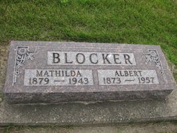
| Birth | : | 9 Feb 1842 Germany |
| Death | : | 14 Feb 1930 Tama County, Iowa, USA |
| Burial | : | Oneida Cemetery, Clutier, Tama County, USA |
| Coordinate | : | 42.1007996, -92.3966980 |
| Plot | : | Section B, Row 2 |
| Inscription | : | Age 88y 5d |
| Description | : | Louisa Glorfeld was born in Westfalen, Prussia, daughter of Christophel Glorfeld. She immigrated to America, an orphan alone at age 16, to join her only relative in The United States, her uncle Carl Glorfeld. Her death was on 14 Feb 1930 in Tama Co, IA. She was married to Asmus Christian Blocker on 31 Dec 1864 in Scott Co., IA. |
frequently asked questions (FAQ):
-
Where is Louisa Glorfeld Blocker's memorial?
Louisa Glorfeld Blocker's memorial is located at: Oneida Cemetery, Clutier, Tama County, USA.
-
When did Louisa Glorfeld Blocker death?
Louisa Glorfeld Blocker death on 14 Feb 1930 in Tama County, Iowa, USA
-
Where are the coordinates of the Louisa Glorfeld Blocker's memorial?
Latitude: 42.1007996
Longitude: -92.3966980
Family Members:
Spouse
Children
Flowers:
Nearby Cemetories:
1. Oneida Cemetery
Clutier, Tama County, USA
Coordinate: 42.1007996, -92.3966980
2. Clutier Cemetery
Clutier, Tama County, USA
Coordinate: 42.0792007, -92.3858032
3. Saint Wenceslaus Cemetery
Clutier, Tama County, USA
Coordinate: 42.0870000, -92.4460000
4. Roadside Cemetery
Clutier, Tama County, USA
Coordinate: 42.0574800, -92.3548800
5. Lone Pine Cemetery
Tama County, USA
Coordinate: 42.0797005, -92.3082962
6. Holy Trinity Cemetery
Vining, Tama County, USA
Coordinate: 42.0293999, -92.4222031
7. Waltham Cemetery
Elberon, Tama County, USA
Coordinate: 42.0355988, -92.3328018
8. Dysart Cemetery
Dysart, Tama County, USA
Coordinate: 42.1608009, -92.3193970
9. Houghton Cemetery
Benton County, USA
Coordinate: 42.1088982, -92.2794037
10. West Union Cemetery
Traer, Tama County, USA
Coordinate: 42.1817017, -92.4449997
11. Bakers Grove Cemetery
Traer, Tama County, USA
Coordinate: 42.1319008, -92.5143967
12. Fee Chapel Cemetery
Tama County, USA
Coordinate: 42.0643997, -92.5117035
13. Saint Pauls Catholic Cemetery
Traer, Tama County, USA
Coordinate: 42.1832000, -92.4688000
14. Twogood Cemetery
Benton County, USA
Coordinate: 42.0499992, -92.2799988
15. Saint Josephs Catholic Cemetery
Benton County, USA
Coordinate: 42.1719017, -92.2981033
16. Saint Marys Cemetery
Vining, Tama County, USA
Coordinate: 41.9906000, -92.3556000
17. Buckingham Cemetery
Traer, Tama County, USA
Coordinate: 42.2069016, -92.4741974
18. Pleasant Hill Cemetery
Toledo, Tama County, USA
Coordinate: 42.1080000, -92.5595000
19. Gnagy Cemetery
Benton County, USA
Coordinate: 42.1418991, -92.2416992
20. Stayskal Cemetery
Vining, Tama County, USA
Coordinate: 41.9788000, -92.4080000
21. National Cemetery
Vining, Tama County, USA
Coordinate: 41.9702988, -92.3705978
22. Rampton Cemetery
Monroe Township, Benton County, USA
Coordinate: 42.1866989, -92.2605972
23. Hayes Cemetery
Toledo, Tama County, USA
Coordinate: 41.9789009, -92.4730988
24. Dvorak Cemetery
Elberon, Tama County, USA
Coordinate: 41.9713000, -92.3417000


