
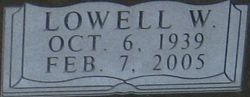

Lowell W Liedtke
| Birth | : | 6 Oct 1939 Concordia, Cloud County, Kansas, USA |
| Death | : | 7 Feb 2005 Franklin County, Kansas, USA |
| Burial | : | Glasco Cemetery, Glasco, Cloud County, USA |
| Coordinate | : | 39.3574000, -97.8265000 |
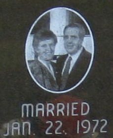
| Description | : | Salina Journal February 11, 2005 Lowell W. Liedtke RANTOUL — Lowell W Liedtke, 65, Rantoul, died Monday, Feb. 7, 2005. Mr. Liedtke was born Oct. 6, 1939, in Concordia. He moved to the Alta Vista area in 1986, where he worked at Pioneer Pork until retiring in June 2004. Survivors include his wife, Jean, of the home; three sons, Allan of North Glenn, Colo., Richard of Parkville, Mo., and Tony of Littleton, Colo.; a daughter, Janea White of Osawatomie; two sisters, Elaine Thornburg of Claremore, Okla., and Karen Stocks of Wichita; four grandchildren; and two step-grandchildren. The funeral will be at 1 p.m. today... Read More |
frequently asked questions (FAQ):
-
Where is Lowell W Liedtke's memorial?
Lowell W Liedtke's memorial is located at: Glasco Cemetery, Glasco, Cloud County, USA.
-
When did Lowell W Liedtke death?
Lowell W Liedtke death on 7 Feb 2005 in Franklin County, Kansas, USA
-
Where are the coordinates of the Lowell W Liedtke's memorial?
Latitude: 39.3574000
Longitude: -97.8265000
Family Members:
Parent

Siblings
Flowers:


Nearby Cemetories:
1. Glasco Cemetery
Glasco, Cloud County, USA
Coordinate: 39.3574000, -97.8265000
2. Saint Marys Catholic Cemetery
Glasco, Cloud County, USA
Coordinate: 39.3574000, -97.8245000
3. Simpson Cemetery
Simpson, Mitchell County, USA
Coordinate: 39.3633003, -97.9471970
4. Bethel Cemetery
Meredith Township, Cloud County, USA
Coordinate: 39.3506000, -97.7029000
5. Delphos Cemetery
Delphos, Ottawa County, USA
Coordinate: 39.2778015, -97.7416992
6. Saint Paul Cemetery
Delphos, Ottawa County, USA
Coordinate: 39.2677994, -97.7518997
7. Asherville Cemetery
Asherville, Mitchell County, USA
Coordinate: 39.4205000, -97.9672900
8. Morrison Cemetery
Center Township, Cloud County, USA
Coordinate: 39.4817009, -97.7975006
9. Summit Cemetery
Jamestown, Cloud County, USA
Coordinate: 39.4813200, -97.8628800
10. Green Mound Cemetery
Asherville, Mitchell County, USA
Coordinate: 39.3203011, -97.9858017
11. Coursen Grove Cemetery
Simpson, Mitchell County, USA
Coordinate: 39.3060989, -97.9792023
12. Hall Cemetery
Cloud County, USA
Coordinate: 39.4455986, -97.7033005
13. Saint Peters Cemetery
Miltonvale, Cloud County, USA
Coordinate: 39.3652350, -97.6483570
14. Bell-Bogardus Cemetery
Asherville, Mitchell County, USA
Coordinate: 39.4242410, -97.9919970
15. Bohemian National Cemetery
Ada, Ottawa County, USA
Coordinate: 39.2193870, -97.9054030
16. Wilcox Cemetery
Cloud County, USA
Coordinate: 39.4925003, -97.7313995
17. West Asher Cemetery
Scottsville, Mitchell County, USA
Coordinate: 39.4815000, -97.9661600
18. Baldwin Cemetery
Ottawa County, USA
Coordinate: 39.2061005, -97.9111023
19. Kindel Cemetery
Center Township, Cloud County, USA
Coordinate: 39.4519005, -97.6464005
20. Smith Cemetery
Asherville, Mitchell County, USA
Coordinate: 39.4516690, -98.0098850
21. McBride Cemetery
Beloit, Mitchell County, USA
Coordinate: 39.4808006, -97.9907990
22. Enterprise Cemetery
Cloud County, USA
Coordinate: 39.4230995, -97.6106033
23. Shiloh Cemetery
Beloit, Mitchell County, USA
Coordinate: 39.3574982, -98.0594025
24. Summit Cemetery #3
Macyville, Cloud County, USA
Coordinate: 39.5258330, -97.9194440