
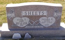
Loyal "Dobe" Sheets
| Birth | : | 7 Aug 1939 |
| Death | : | 15 May 2006 |
| Burial | : | St. Chad Churchyard, Kirkby, Metropolitan Borough of Knowsley, England |
| Coordinate | : | 53.4842890, -2.8930700 |
| Description | : | Loyal "Dobe" Sheets, 66 of Cozad, Nebraska, died May 15, 2006, at the Cozad Hospital. He was born August 7, 1939, at Arnold, Nebraska, to Claude and Etta Wilson Sheets. He attended schools in Custer County and graduated from Cozad High School in 1957. He attended Wesleyan University. For several years, he was employed with Douglas Power Line Construction, traveling throughout the country installing electrical lines. He worked for the City of Cozad Light & Power Department. On July 30, 1966, he married Sandy Spradlin. In 1966, he was employed with the Cozad Telephone Co., working as a service repairman until... Read More |
frequently asked questions (FAQ):
-
Where is Loyal "Dobe" Sheets's memorial?
Loyal "Dobe" Sheets's memorial is located at: St. Chad Churchyard, Kirkby, Metropolitan Borough of Knowsley, England.
-
When did Loyal "Dobe" Sheets death?
Loyal "Dobe" Sheets death on 15 May 2006 in
-
Where are the coordinates of the Loyal "Dobe" Sheets's memorial?
Latitude: 53.4842890
Longitude: -2.8930700
Family Members:
Siblings

Flowers:


Nearby Cemetories:
1. St. Chad Churchyard
Kirkby, Metropolitan Borough of Knowsley, England
Coordinate: 53.4842890, -2.8930700
2. Melling Churchyard
Melling, Metropolitan Borough of Sefton, England
Coordinate: 53.4953370, -2.9228780
3. St Thomas and the Holy Rood Churchyard
Melling, Metropolitan Borough of Sefton, England
Coordinate: 53.4954510, -2.9227850
4. St Swithins Churchyard
Liverpool, Metropolitan Borough of Liverpool, England
Coordinate: 53.4585631, -2.9012280
5. West Derby Cemetery
West Derby, Metropolitan Borough of Liverpool, England
Coordinate: 53.4513790, -2.9154630
6. West Derby Jewish Cemetery
Liverpool, Metropolitan Borough of Liverpool, England
Coordinate: 53.4504986, -2.9137393
7. Kirkdale Cemetery
Liverpool, Metropolitan Borough of Liverpool, England
Coordinate: 53.4672530, -2.9479800
8. St. Mary's Churchyard
Knowsley, Metropolitan Borough of Knowsley, England
Coordinate: 53.4561960, -2.8528580
9. Aintree Racecourse Grounds
Aintree Village, Metropolitan Borough of Sefton, England
Coordinate: 53.4733880, -2.9549700
10. St. Andrew Churchyard
Maghull, Metropolitan Borough of Sefton, England
Coordinate: 53.5104770, -2.9428820
11. Long Lane Jewish Cemetery
Liverpool, Metropolitan Borough of Liverpool, England
Coordinate: 53.4550140, -2.9420480
12. Everton Cemetery
Everton, Metropolitan Borough of Liverpool, England
Coordinate: 53.4555430, -2.9442480
13. Sefton Parish Churchyard
Sefton, Metropolitan Borough of Sefton, England
Coordinate: 53.5044060, -2.9712190
14. Rice Lane Jewish Cemetery
Walton, Metropolitan Borough of Liverpool, England
Coordinate: 53.4521700, -2.9590600
15. Friends Burial Ground
Bickerstaffe, West Lancashire District, England
Coordinate: 53.5347720, -2.8748780
16. GreenAcres Cemetery
Rainford, Metropolitan Borough of St Helens, England
Coordinate: 53.4713530, -2.8064280
17. Walton Park Cemetery
Walton, Metropolitan Borough of Liverpool, England
Coordinate: 53.4564370, -2.9695960
18. Bootle Cemetery
Bootle, Metropolitan Borough of Sefton, England
Coordinate: 53.4627680, -2.9787450
19. Yew Tree Roman Catholic Cemetery
West Derby, Metropolitan Borough of Liverpool, England
Coordinate: 53.4285700, -2.8790700
20. Holy Trinity Church
Bickerstaffe, West Lancashire District, England
Coordinate: 53.5318400, -2.8383400
21. St Mary the Virgin Churchyard
Walton, Metropolitan Borough of Liverpool, England
Coordinate: 53.4464930, -2.9673330
22. Ford Cemetery
Ford, Metropolitan Borough of Sefton, England
Coordinate: 53.4824040, -2.9925980
23. Saint Michael's Churchyard
Aughton, West Lancashire District, England
Coordinate: 53.5419170, -2.9197240
24. Anfield Cemetery and Crematorium
Anfield, Metropolitan Borough of Liverpool, England
Coordinate: 53.4354680, -2.9578100