
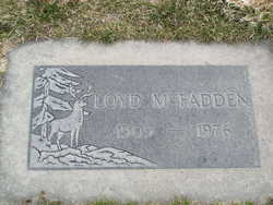
Loyd McFadden
| Birth | : | 5 Jul 1909 Ralston, Pawnee County, Oklahoma, USA |
| Death | : | 18 Jan 1976 Chelan, Chelan County, Washington, USA |
| Burial | : | Chelan Fraternal Cemetery, Chelan, Chelan County, USA |
| Coordinate | : | 47.8502998, -120.0081024 |
| Plot | : | North Fraternal Row64 STBLK61 LS7 |
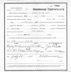
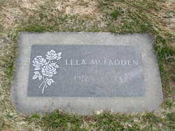
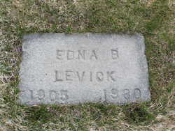
| Description | : | Loyd McFadden, 66, of Manson, died Sunday morning following a sudden illness. He was born July 5, 1909, at Ralston, Okla. In 1932 he came to Manson and later married Lela Clapp, July 3, 1933, at Wenatchee. Surviving are his wife, Lela, at home; one daughter, Mary Louise Johnson of Oxnard, Calif., three sisters, Edna Levick of Manson, Maxine Clapp of Kellogg, Idaho, and Hazel Chamberland of Vancouver; three grandchildren and two great-grandchildren. |
frequently asked questions (FAQ):
-
Where is Loyd McFadden's memorial?
Loyd McFadden's memorial is located at: Chelan Fraternal Cemetery, Chelan, Chelan County, USA.
-
When did Loyd McFadden death?
Loyd McFadden death on 18 Jan 1976 in Chelan, Chelan County, Washington, USA
-
Where are the coordinates of the Loyd McFadden's memorial?
Latitude: 47.8502998
Longitude: -120.0081024
Family Members:
Parent

Spouse
Siblings
Flowers:


Nearby Cemetories:
1. Chelan Fraternal Cemetery
Chelan, Chelan County, USA
Coordinate: 47.8502998, -120.0081024
2. Mount Olivet Cemetery
Chelan, Chelan County, USA
Coordinate: 47.8451000, -119.9946000
3. Saint Andrews Episcopal Church
Chelan, Chelan County, USA
Coordinate: 47.8397460, -120.0183780
4. Riverview Cemetery
Chelan, Chelan County, USA
Coordinate: 47.8335991, -119.9944000
5. Manson Indian Cemetery
Manson, Chelan County, USA
Coordinate: 47.8800000, -120.1300000
6. Ballard Family Cemetery
Stayman, Chelan County, USA
Coordinate: 47.7811100, -120.1133300
7. Fletcher Cemetery
Douglas County, USA
Coordinate: 47.7430992, -119.9403000
8. Brays Landing Cemetery
Douglas County, USA
Coordinate: 47.7364120, -120.1704660
9. Kummer Cemetery
Waterville, Douglas County, USA
Coordinate: 47.6559000, -120.0332000
10. Packwood Memorial Cemetery
Dyer, Douglas County, USA
Coordinate: 48.0118305, -119.8178880
11. Dick Family Cemetery
Okanogan County, USA
Coordinate: 48.0502700, -119.9241700
12. Miller Family Cemetery
Okanogan County, USA
Coordinate: 48.0530300, -119.9288000
13. Pateros Cemetery
Pateros, Okanogan County, USA
Coordinate: 48.0516600, -119.9097300
14. Waterville Cemetery
Waterville, Douglas County, USA
Coordinate: 47.6418500, -120.0685940
15. Gate of Heaven Catholic Cemetery
Waterville, Douglas County, USA
Coordinate: 47.6382100, -120.0671690
16. Douglas Lutheran Cemetery
Douglas County, USA
Coordinate: 47.6189003, -119.9614029
17. Badger Mountain View Cemetery
Douglas County, USA
Coordinate: 47.6088000, -120.0476000
18. Mansfield Cemetery
Mansfield, Douglas County, USA
Coordinate: 47.8088880, -119.6508330
19. Orondo Community Cemetery
Orondo, Douglas County, USA
Coordinate: 47.6486015, -120.2136002
20. Buckingham Cemetery
Douglas County, USA
Coordinate: 47.8669014, -119.6286011
21. Happy Home Cemetery
Farmer, Douglas County, USA
Coordinate: 47.6268997, -119.8125000
22. Methow Cemetery
Methow, Okanogan County, USA
Coordinate: 48.1102982, -120.0124969
23. Entiat Cemetery
Entiat, Chelan County, USA
Coordinate: 47.6755981, -120.3043976
24. Bridgeport Cemetery
Bridgeport, Douglas County, USA
Coordinate: 48.0050000, -119.6738800