Lucy Ann Saunders Gough
| Birth | : | 22 Feb 1822 Missouri, USA |
| Death | : | 15 Mar 1842 Missouri, USA |
| Burial | : | Carson City Cemetery, Carson City, Montcalm County, USA |
| Coordinate | : | 43.1850300, -84.8508400 |
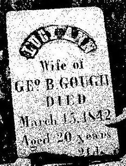
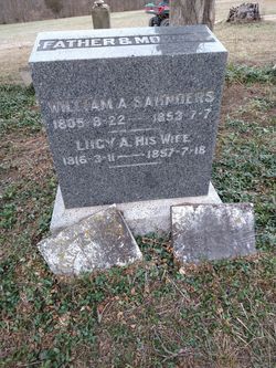
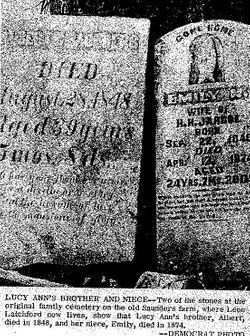
| Description | : | First wife of George Beaven Gough, married about 1841. Pioneer family Saunders family burial plot produces oldest known tombstone in county At a farm sale some months ago, an old harrow, weighted down for better results in working the soil, was sold to Ernest Saunders of Lakenan. Mr. Saunders wanted the weights, not the harrow, for the weights were grave markers of his family, about four generations back. It was in this manner that the oldest known grave marker in Shelby county was located, and came to light, after the publicity given by Will Davis, of the Shelbina Democrat,... Read More |
frequently asked questions (FAQ):
-
Where is Lucy Ann Saunders Gough's memorial?
Lucy Ann Saunders Gough's memorial is located at: Carson City Cemetery, Carson City, Montcalm County, USA.
-
When did Lucy Ann Saunders Gough death?
Lucy Ann Saunders Gough death on 15 Mar 1842 in Missouri, USA
-
Where are the coordinates of the Lucy Ann Saunders Gough's memorial?
Latitude: 43.1850300
Longitude: -84.8508400
Family Members:
Parent
Spouse
Siblings
Flowers:
Nearby Cemetories:
1. Carson City Cemetery
Carson City, Montcalm County, USA
Coordinate: 43.1850300, -84.8508400
2. Saint Marys Cemetery
Carson City, Montcalm County, USA
Coordinate: 43.1847600, -84.8508400
3. Mount Calm Mennonite Church Cemetery
Carson City, Montcalm County, USA
Coordinate: 43.1801800, -84.8372300
4. Burke Cemetery
Carson City, Montcalm County, USA
Coordinate: 43.2196999, -84.8852997
5. Bloomer Township Cemetery
Carson City, Montcalm County, USA
Coordinate: 43.1516991, -84.8949966
6. Vickeryville Old Order Mennonite Church Cemetery
Vickeryville, Montcalm County, USA
Coordinate: 43.1734880, -84.9342820
7. Crystal Cemetery
Crystal, Montcalm County, USA
Coordinate: 43.2347470, -84.9158600
8. Dalton Cemetery
Carson City, Montcalm County, USA
Coordinate: 43.1202400, -84.9157500
9. New Haven Township Cemetery
New Haven Center, Gratiot County, USA
Coordinate: 43.2487230, -84.7828580
10. Vickeryville Cemetery
Vickeryville, Montcalm County, USA
Coordinate: 43.1917000, -84.9760971
11. Westside Cemetery
Hubbardston, Ionia County, USA
Coordinate: 43.0928001, -84.8506012
12. Saint John the Baptist Catholic Cemetery
Hubbardston, Ionia County, USA
Coordinate: 43.0924988, -84.8486023
13. East Side Cemetery
Hubbardston, Ionia County, USA
Coordinate: 43.0927730, -84.8381800
14. Hubbardston Old Catholic Cemetery
Hubbardston, Ionia County, USA
Coordinate: 43.0908960, -84.8590590
15. Palo Cemetery
Palo, Ionia County, USA
Coordinate: 43.1100000, -84.9380000
16. Woodward Cemetery
Hubbardston, Ionia County, USA
Coordinate: 43.0893300, -84.8913600
17. Spencer Cemetery
Crystal, Montcalm County, USA
Coordinate: 43.2883700, -84.8555700
18. Greenwood Cemetery
Middleton, Gratiot County, USA
Coordinate: 43.2118988, -84.7093964
19. Wildwood Mennonite Church Cemetery
Perrinton, Gratiot County, USA
Coordinate: 43.1453370, -84.7052760
20. Sunny Hill Cemetery
Fenwick, Montcalm County, USA
Coordinate: 43.1319008, -85.0002975
21. Klees Cemetery
Montcalm County, USA
Coordinate: 43.3066340, -84.8607230
22. Payne Cemetery
Fulton Township, Gratiot County, USA
Coordinate: 43.1204400, -84.7084800
23. Sumner Cemetery
Sumner, Gratiot County, USA
Coordinate: 43.3139000, -84.8242035
24. Roosa Farm Cemetery
Sumner Township, Gratiot County, USA
Coordinate: 43.2922139, -84.7477728


