

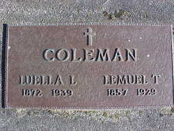
Luella Lera Littlefield Coleman
| Birth | : | 16 Jul 1872 Dover-Foxcroft, Piscataquis County, Maine, USA |
| Death | : | 15 Mar 1939 Sedro-Woolley, Skagit County, Washington, USA |
| Burial | : | Bacup Cemetery, Bacup, Rossendale Borough, England |
| Coordinate | : | 53.6906780, -2.2156640 |
| Plot | : | Old Section |
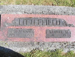
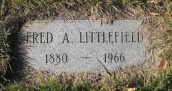
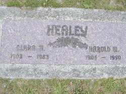
| Inscription | : | COLEMAN LUELLA L ----- LEMUEL T 1872-1939 --- 1857-1929 |
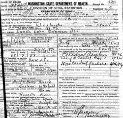
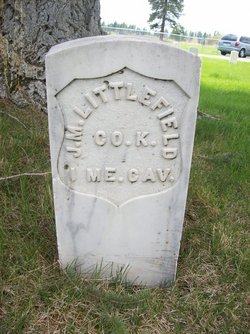
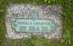
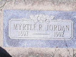
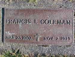
| Description | : | Maine, Birth Records, 1715-1922 Name: Luella Lera Littlefield Gender: Female Birth Date: 16 Jul 1872 Birth Place: Dover-Foxcroft, Piscataquis, Maine, USA Father: Joshua Mitchel Littlefield Mother: Rosilla F. Littlefield ================ Luella L. Littlefield married Lemuel T. Coleman on 26 October 1896 in Sand Coulee, Cascade County, Montana. On 19 April 1910 Lemuel T. Coleman (52), wife Luella (37), children; Myrtle R. (12), Minnie D. (12), Marion M. (11), Francis L. (8), Clara M. (6), Clifford D. (4), Laura E. (3), Mary J. (11/12), Thomas G. (16) lived in Poe Township, Ringgold County, Iowa. Thomas and... Read More |
frequently asked questions (FAQ):
-
Where is Luella Lera Littlefield Coleman's memorial?
Luella Lera Littlefield Coleman's memorial is located at: Bacup Cemetery, Bacup, Rossendale Borough, England.
-
When did Luella Lera Littlefield Coleman death?
Luella Lera Littlefield Coleman death on 15 Mar 1939 in Sedro-Woolley, Skagit County, Washington, USA
-
Where are the coordinates of the Luella Lera Littlefield Coleman's memorial?
Latitude: 53.6906780
Longitude: -2.2156640
Family Members:
Parent
Spouse
Siblings
Children

Flowers:


Nearby Cemetories:
1. Mount Pleasant Wesleyan Chapelyard
Bacup, Rossendale Borough, England
Coordinate: 53.6924900, -2.2228100
2. St John the Evangelist Churchyard
Bacup, Rossendale Borough, England
Coordinate: 53.7037300, -2.2019600
3. Ebenezer Particular Baptist Chapel Chapelyard
Bacup, Rossendale Borough, England
Coordinate: 53.7045700, -2.1997500
4. Newchurch Methodist Churchyard
Newchurch, Rossendale Borough, England
Coordinate: 53.6983460, -2.2501260
5. St. Nicholas Churchyard
Newchurch, Rossendale Borough, England
Coordinate: 53.6972220, -2.2524660
6. Bethlehem Chapel Graveyard
Newchurch, Rossendale Borough, England
Coordinate: 53.6976970, -2.2522620
7. Saint Anne's Churchyard Edgeside
Waterfoot, Rossendale Borough, England
Coordinate: 53.7031600, -2.2482700
8. Saint Michael on the Hill Churchyard
Lumb, Rossendale Borough, England
Coordinate: 53.7201000, -2.2479300
9. Lumb Baptist Church Cemetery
Waterfoot, Rossendale Borough, England
Coordinate: 53.7229340, -2.2455170
10. Whitworth Cemetery
Whitworth, Rossendale Borough, England
Coordinate: 53.6671650, -2.1674750
11. Friends Burial Ground
Rossendale, Rossendale Borough, England
Coordinate: 53.7091000, -2.2757160
12. Unitarian Chapel Burial Ground
Rossendale, Rossendale Borough, England
Coordinate: 53.7024380, -2.2856290
13. Longholme Methodist Cemetery
Rawtenstall, Rossendale Borough, England
Coordinate: 53.7009730, -2.2865000
14. Rawtenstall Cemetery
Rawtenstall, Rossendale Borough, England
Coordinate: 53.7060200, -2.2847500
15. St Bartholomew Churchyard
Whitworth, Rossendale Borough, England
Coordinate: 53.6553000, -2.1709700
16. Cloughfoot Independent Congregational Chapelyard
Todmorden, Metropolitan Borough of Calderdale, England
Coordinate: 53.7113850, -2.1379180
17. Broadleys Garden
Rawtenstall, Rossendale Borough, England
Coordinate: 53.7176321, -2.2904764
18. Burnley Road Cemetery, Reedsholme, Rossendale
Rossendale Borough, England
Coordinate: 53.7178398, -2.2904316
19. Crawshawbooth Quaker Burial Ground
Crawshawbooth, Rossendale Borough, England
Coordinate: 53.7242420, -2.2879400
20. Edenfield Parish Churchyard
Ramsbottom, Metropolitan Borough of Bury, England
Coordinate: 53.6742799, -2.3069304
21. St. Mary and All Saints Churchyard
Goodshaw, Rossendale Borough, England
Coordinate: 53.7315270, -2.2828940
22. Goodshaw Particular Baptist Chapel Graveyard
Goodshaw, Rossendale Borough, England
Coordinate: 53.7328210, -2.2815530
23. Christ Church Churchyard
Healey, Metropolitan Borough of Rochdale, England
Coordinate: 53.6378630, -2.1741198
24. Mount Zion Methodist Chapleyard
Cornholme, Metropolitan Borough of Calderdale, England
Coordinate: 53.7331400, -2.1457800