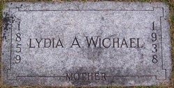
Lydia A Walker Wichael
| Birth | : | 12 Jul 1859 Collins, Story County, Iowa, USA |
| Death | : | 20 Sep 1938 Omaha, Douglas County, Nebraska, USA |
| Burial | : | Mooreland Cemetery, Paxton, Worcester County, USA |
| Coordinate | : | 42.3280800, -71.9321000 |
| Plot | : | Acacia Sec - Lot 134 - Grave 8 |
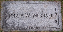
| Description | : | Newspaper Unknown (Pottawattamie, Iowa) 20 Sep 1938 – Mrs. Lydia Wichael Mrs. Lydia Wichael, 79, formerly of Council Bluffs, died suddenly at 5 a.m. Tuesday at the home of her daughter, Mrs. John Ford, Jr. 357 North Forty-First Avenue, Omaha of thrombosis. Mrs. Wichael was the widow of P. W. Wichael, Rock Island railroad express agent. He died about twenty years ago. She was born July 12, 1859 near Marshalltown, Ia. She came to Council Bluffs in 1902 and resided here for about twenty years. In 1922 she moved to Omaha to make her home with her daughter. ... Read More |
frequently asked questions (FAQ):
-
Where is Lydia A Walker Wichael's memorial?
Lydia A Walker Wichael's memorial is located at: Mooreland Cemetery, Paxton, Worcester County, USA.
-
When did Lydia A Walker Wichael death?
Lydia A Walker Wichael death on 20 Sep 1938 in Omaha, Douglas County, Nebraska, USA
-
Where are the coordinates of the Lydia A Walker Wichael's memorial?
Latitude: 42.3280800
Longitude: -71.9321000
Family Members:
Parent
Spouse
Siblings
Children
Flowers:
Nearby Cemetories:
1. Mooreland Cemetery
Paxton, Worcester County, USA
Coordinate: 42.3280800, -71.9321000
2. Worcester County Memorial Park
Paxton, Worcester County, USA
Coordinate: 42.3245697, -71.9308777
3. Paxton Center Cemetery
Paxton, Worcester County, USA
Coordinate: 42.3128900, -71.9277700
4. Putnam Farm Cemetery
Rutland, Worcester County, USA
Coordinate: 42.3484010, -71.9771420
5. Elliot Hill Burial Ground
Leicester, Worcester County, USA
Coordinate: 42.2802200, -71.9145500
6. West Rutland Cemetery
Rutland, Worcester County, USA
Coordinate: 42.3561970, -71.9897170
7. Old Burial Ground
Rutland, Worcester County, USA
Coordinate: 42.3756000, -71.9578000
8. Rutland Rural Cemetery
Rutland, Worcester County, USA
Coordinate: 42.3790100, -71.9447500
9. Saint Mary Cemetery
Holden, Worcester County, USA
Coordinate: 42.3522400, -71.8684200
10. Grove Cemetery
Holden, Worcester County, USA
Coordinate: 42.3520400, -71.8672700
11. Park Avenue Cemetery
Holden, Worcester County, USA
Coordinate: 42.3514200, -71.8656900
12. Old Burying Ground
Holden, Worcester County, USA
Coordinate: 42.3505800, -71.8626000
13. Saint Francis Episcopal Church Memorial Garden
Holden, Worcester County, USA
Coordinate: 42.3522800, -71.8588700
14. Saint Joseph's Abbey Grounds
Spencer, Worcester County, USA
Coordinate: 42.2935500, -71.9990800
15. Smith Family Cemetery
Rutland, Worcester County, USA
Coordinate: 42.3946064, -71.9231169
16. Quaker Cemetery
Leicester, Worcester County, USA
Coordinate: 42.2635600, -71.8960300
17. Green Hollow Cemetery
Oakham, Worcester County, USA
Coordinate: 42.3549995, -72.0243988
18. Nazareth Home for Boys Cemetery
Leicester, Worcester County, USA
Coordinate: 42.2600000, -71.8892000
19. South Cemetery
Oakham, Worcester County, USA
Coordinate: 42.3382988, -72.0374985
20. Rutland Prison Camp Cemetery
Rutland, Worcester County, USA
Coordinate: 42.3988500, -71.9923800
21. Rawson Brook Burial Ground
Leicester, Worcester County, USA
Coordinate: 42.2453900, -71.9152600
22. Goose Hill Cemetery
Rutland, Worcester County, USA
Coordinate: 42.3997400, -71.9914000
23. Oakham Center Cemetery
Oakham, Worcester County, USA
Coordinate: 42.3540000, -72.0421400
24. Saint Josephs Cemetery
Leicester, Worcester County, USA
Coordinate: 42.2467003, -71.8874969

