
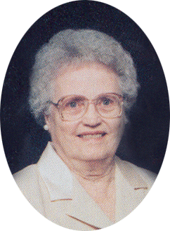
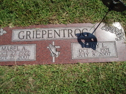

Mabel A. Cattau Griepentrog
| Birth | : | 27 Oct 1922 Platte County, Nebraska, USA |
| Death | : | 17 Nov 2007 San Marcos, Hays County, Texas, USA |
| Burial | : | South Maitland United Church Cemetery, South Maitland, Hants County, Canada |
| Coordinate | : | 45.2404910, -63.4589410 |
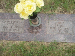
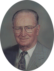
| Description | : | Daughter of Rudolf & Clara (Behrens) Cattau. Mabel was baptized at Christ Lutheran Church and confirmed on May 29, 1936. She received her education at Christ Lutheran School. On June 1, 1941, Mabel married LeRoy Griepentrog at Christ Lutheran Church. She worked for 28 years at Becton Dickinson in Columbus and was a member of Peace Lutheran Church where she was active in the visitation and care community organizations. Mabel did volunteer work at the Columbus Senior Center, the Columbus Manor (Golden Living Center), and was volunteer of the year. She was a leader of the Senior Aerobics and... Read More |
frequently asked questions (FAQ):
-
Where is Mabel A. Cattau Griepentrog's memorial?
Mabel A. Cattau Griepentrog's memorial is located at: South Maitland United Church Cemetery, South Maitland, Hants County, Canada.
-
When did Mabel A. Cattau Griepentrog death?
Mabel A. Cattau Griepentrog death on 17 Nov 2007 in San Marcos, Hays County, Texas, USA
-
Where are the coordinates of the Mabel A. Cattau Griepentrog's memorial?
Latitude: 45.2404910
Longitude: -63.4589410
Family Members:
Parent

Spouse
Siblings

Flowers:


Nearby Cemetories:
1. South Maitland United Church Cemetery
South Maitland, Hants County, Canada
Coordinate: 45.2404910, -63.4589410
2. Fisher Creek Cemetery
Green Oaks, Colchester County, Canada
Coordinate: 45.2606300, -63.4475470
3. Green Oaks Calvary Union Cemetery
Green Oaks, Colchester County, Canada
Coordinate: 45.2435905, -63.4207847
4. Greens Creek Cemetery
Green Creek, Colchester County, Canada
Coordinate: 45.2495730, -63.3893970
5. Saint John The Baptist Anglican Church Cemetery
Maple Grove, Hants County, Canada
Coordinate: 45.2422390, -63.5526470
6. Saint Francis Xavier Roman Catholic Cemetery
Maitland, Hants County, Canada
Coordinate: 45.3101390, -63.4900170
7. Holy Trinity Anglican Church Cemetery
Maitland, Hants County, Canada
Coordinate: 45.3100830, -63.5059720
8. Admiral Rock United Church Cemetery
Admiral Rock, Hants County, Canada
Coordinate: 45.1688330, -63.4045730
9. South Maitland Cemetery
South Maitland, Hants County, Canada
Coordinate: 45.3180260, -63.4972000
10. Saint David's United Church Cemetery
Maitland, Hants County, Canada
Coordinate: 45.3173920, -63.5000690
11. Oak Island Cemetery
Maitland, Hants County, Canada
Coordinate: 45.3178910, -63.5003540
12. Lower Pleasant Valley Cemetery
Pleasant Valley, Colchester County, Canada
Coordinate: 45.2496340, -63.3347230
13. Dartt Family Cemetery
Pleasant Valley, Colchester County, Canada
Coordinate: 45.2422610, -63.3306460
14. Shortt Family Catholic Cemetery
Pleasant Valley, Colchester County, Canada
Coordinate: 45.2436510, -63.3244230
15. Old Clifton Cemetery
Clifton, Colchester County, Canada
Coordinate: 45.3323900, -63.4190100
16. Selma United Church Cemetery
Selma, Hants County, Canada
Coordinate: 45.3218840, -63.5359470
17. Old Barns Cemetery
Old Barns, Colchester County, Canada
Coordinate: 45.3359930, -63.4115360
18. United Church Cemetery
Clifton, Colchester County, Canada
Coordinate: 45.3367800, -63.4118300
19. Christ Church Cemetery
Beaver Brook, Colchester County, Canada
Coordinate: 45.3371240, -63.4112830
20. Brookfield First Settlers Cemetery
Brookfield, Colchester County, Canada
Coordinate: 45.2494267, -63.2976256
21. Five Mile River Cemetery
Five Mile River, Hants County, Canada
Coordinate: 45.2161900, -63.6176900
22. Holy Trinity Anglican Church Cemetery
Stewiacke, Colchester County, Canada
Coordinate: 45.1488590, -63.3484340
23. Lower Selma Heritage Cemetery
Lower Selma, Hants County, Canada
Coordinate: 45.3130200, -63.6002500
24. Hilden Cemetery
Hilden, Colchester County, Canada
Coordinate: 45.2913000, -63.2910300