
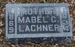
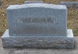
Mabel G. Ferris Lachner
| Birth | : | 6 Apr 1869 Lansing, Allamakee County, Iowa, USA |
| Death | : | 5 Dec 1934 Spencer, Clay County, Iowa, USA |
| Burial | : | St. Mary's Churchyard, Hellesdon, Broadland District, England |
| Coordinate | : | 52.6486720, 1.2515280 |
| Description | : | Wife of John Lachner - don't know if he is also buried here. |
frequently asked questions (FAQ):
-
Where is Mabel G. Ferris Lachner's memorial?
Mabel G. Ferris Lachner's memorial is located at: St. Mary's Churchyard, Hellesdon, Broadland District, England.
-
When did Mabel G. Ferris Lachner death?
Mabel G. Ferris Lachner death on 5 Dec 1934 in Spencer, Clay County, Iowa, USA
-
Where are the coordinates of the Mabel G. Ferris Lachner's memorial?
Latitude: 52.6486720
Longitude: 1.2515280
Family Members:
Parent
Siblings

Children
Flowers:


Nearby Cemetories:
1. St. Mary's Churchyard
Hellesdon, Broadland District, England
Coordinate: 52.6486720, 1.2515280
2. St. Mary's New Burial Ground
Hellesdon, Broadland District, England
Coordinate: 52.6495480, 1.2520370
3. St. Bartholomew's Churchyard Heigham
Norwich, City of Norwich, England
Coordinate: 52.6401560, 1.2743680
4. Earlham Road Cemetery
Norwich, City of Norwich, England
Coordinate: 52.6305900, 1.2677400
5. St. Mary's Churchyard
Earlham, City of Norwich, England
Coordinate: 52.6280416, 1.2353034
6. St Michael's Church
Bowthorpe, City of Norwich, England
Coordinate: 52.6359300, 1.2163600
7. Our Lady & St. Walstan Churchyard
Costessey, South Norfolk District, England
Coordinate: 52.6583200, 1.2119300
8. St. Edmund's Churchyard
Costessey, South Norfolk District, England
Coordinate: 52.6660400, 1.2183410
9. Costessey Baptist Churchyard
Costessey, South Norfolk District, England
Coordinate: 52.6600122, 1.2116993
10. St. Martin at Oak Church
Norwich, City of Norwich, England
Coordinate: 52.6348420, 1.2901930
11. St. Benedict's Churchyard
Norwich, City of Norwich, England
Coordinate: 52.6311700, 1.2860580
12. Quaker Burial Ground
Norwich, City of Norwich, England
Coordinate: 52.6361120, 1.2914810
13. St. Augustine's Churchyard
Norwich, City of Norwich, England
Coordinate: 52.6371000, 1.2925960
14. Cathedral of Saint John the Baptist
Norwich, City of Norwich, England
Coordinate: 52.6292000, 1.2840000
15. St. Swithin Churchyard
Norwich, City of Norwich, England
Coordinate: 52.6316140, 1.2877760
16. St Mary Coslany Churchyard
Norwich, City of Norwich, England
Coordinate: 52.6341180, 1.2914040
17. Saint Margaret's Churchyard
Norwich, City of Norwich, England
Coordinate: 52.6313370, 1.2886400
18. Christ Churchyard, New Catton
Norwich, City of Norwich, England
Coordinate: 52.6438540, 1.2977320
19. St Margaret de Westwick Parish Church
Norwich, City of Norwich, England
Coordinate: 52.6313610, 1.2887497
20. St. Margaret's Churchyard
Norwich, City of Norwich, England
Coordinate: 52.6312260, 1.2886730
21. Costessey Parish Cemetery
Costessey, South Norfolk District, England
Coordinate: 52.6495927, 1.2040157
22. St. Michael of Closany Churchyard
Norwich, City of Norwich, England
Coordinate: 52.6329950, 1.2914510
23. Saint Michael Coslany Parish Churchyard
Norwich, City of Norwich, England
Coordinate: 52.6329420, 1.2914110
24. St Giles Churchyard
Norwich, City of Norwich, England
Coordinate: 52.6294900, 1.2871500