

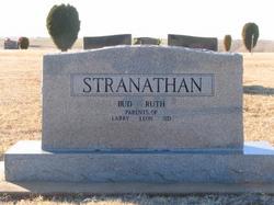
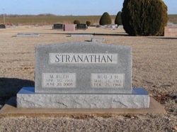
Mabel Ruth Wolgamott Stranathan
| Birth | : | 30 Apr 1918 Barber County, Kansas, USA |
| Death | : | 20 Jun 2005 Anthony, Harper County, Kansas, USA |
| Burial | : | Holy Sepulchre Cemetery, Omaha, Douglas County, USA |
| Coordinate | : | 41.2543983, -95.9875031 |
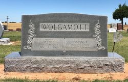
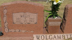
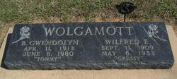
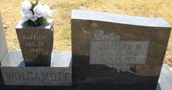
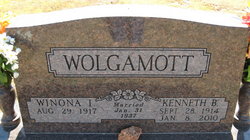
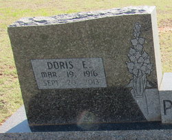
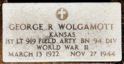
| Description | : | Siblings: Lewis Wayne, Willis Lyman, Wilford Ernest, Francis Willard, Clifford Wilmer, Kenneth Blaine, Doris Ernestine, Donald Dean, George Reese, Virginia Nellie, Mary Lee. On June 9, 1940, she married Bud Stranathan. She was preceded in death by seven brothers and two sisters. Joseph Wolgemuth (1714-1775) .Joseph Wolgamott (1750-1847) ..David Wolgamott (1773-1844) ...David Wolgamott(1802-1884) ....John J. Wolgamott (1825-1908) .....Abner L. Wolgamott (1856-1936) ......Lyman Ernest Wolgamott(1881-1964) |
frequently asked questions (FAQ):
-
Where is Mabel Ruth Wolgamott Stranathan's memorial?
Mabel Ruth Wolgamott Stranathan's memorial is located at: Holy Sepulchre Cemetery, Omaha, Douglas County, USA.
-
When did Mabel Ruth Wolgamott Stranathan death?
Mabel Ruth Wolgamott Stranathan death on 20 Jun 2005 in Anthony, Harper County, Kansas, USA
-
Where are the coordinates of the Mabel Ruth Wolgamott Stranathan's memorial?
Latitude: 41.2543983
Longitude: -95.9875031
Family Members:
Parent

Spouse
Siblings
Flowers:


Nearby Cemetories:
1. Holy Sepulchre Cemetery
Omaha, Douglas County, USA
Coordinate: 41.2543983, -95.9875031
2. Douglas County Poor Farm Cemetery
Omaha, Douglas County, USA
Coordinate: 41.2437240, -95.9723480
3. First Central Congregational Columbarium
Omaha, Douglas County, USA
Coordinate: 41.2563456, -95.9658365
4. Bohemian Cemetery
Omaha, Douglas County, USA
Coordinate: 41.2388992, -95.9955978
5. Nash Chapel Crypt
Omaha, Douglas County, USA
Coordinate: 41.2665090, -95.9721790
6. Westlawn-Hillcrest Memorial Park
Omaha, Douglas County, USA
Coordinate: 41.2346992, -95.9966965
7. Ak-Sar-Ben Racetrack Grounds
Omaha, Douglas County, USA
Coordinate: 41.2414703, -96.0159607
8. Prospect Hill Cemetery
Omaha, Douglas County, USA
Coordinate: 41.2780991, -95.9593964
9. Calvary Cemetery
Omaha, Douglas County, USA
Coordinate: 41.2364006, -96.0294037
10. Trinity Cathedral Columbarium
Omaha, Douglas County, USA
Coordinate: 41.2603900, -95.9393660
11. Evergreen Memorial Park Cemetery
Omaha, Douglas County, USA
Coordinate: 41.2393990, -96.0355988
12. Saint Andrews Episcopal Church Columbarium
Omaha, Douglas County, USA
Coordinate: 41.2492500, -96.0427500
13. Resurrection Cemetery
Omaha, Douglas County, USA
Coordinate: 41.2344208, -96.0365448
14. Graceland Park Cemetery
Omaha, Douglas County, USA
Coordinate: 41.2113991, -95.9785995
15. Countryside Community Church Columbarium
Omaha, Douglas County, USA
Coordinate: 41.2483660, -96.0500270
16. Saint Mary Magdalene Cemetery
Omaha, Douglas County, USA
Coordinate: 41.2039420, -95.9850610
17. Golden Hill Cemetery
Omaha, Douglas County, USA
Coordinate: 41.3050003, -95.9744034
18. Saint Mary's Cemetery
Omaha, Douglas County, USA
Coordinate: 41.2042007, -95.9646988
19. Servants of Mary Cemetery
Omaha, Douglas County, USA
Coordinate: 41.3017170, -96.0258260
20. All Saints Episcopal Church Columbarium
Omaha, Douglas County, USA
Coordinate: 41.2785000, -96.0579000
21. Springwell Cemetery
Omaha, Douglas County, USA
Coordinate: 41.3114014, -96.0096970
22. Beth El Cemetery
Ralston, Douglas County, USA
Coordinate: 41.2117004, -96.0428009
23. Mount Hope Cemetery
Omaha, Douglas County, USA
Coordinate: 41.3041992, -96.0310974
24. Pleasant Hill Jewish Cemetery
Omaha, Douglas County, USA
Coordinate: 41.3185997, -95.9766998