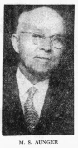
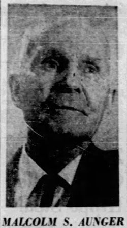
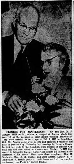
Malcolm Stanbury “Stan” Aunger
| Birth | : | 24 May 1881 Haydon, Durham Regional Municipality, Ontario, Canada |
| Death | : | 16 May 1969 Edmonton, Edmonton Census Division, Alberta, Canada |
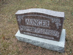
| Burial | : | Akatarawa Cemetery, Upper Hutt City, New Zealand |
| Coordinate | : | -41.0876320, 175.1025870 |
| Plot | : | F 0195 0001 |
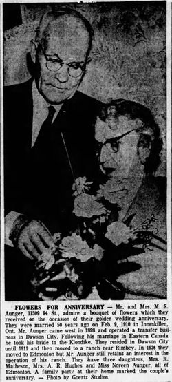
| Description | : | Malcomb Stanbury Aunger, (who never used his first name), was the son of William Aunger and Jane Reid. He was probably born in Kingston, Ontario, Canada. He ran dogsleds with provisions into Skagway, Alaska, around 1900, where his first cousin, Margaret Jane Mooney, ran a hotel. He also made trips to California to visit his couin Charles Delos Mooney in St. Helena, and William Mooney, in the Los Angeles area. ON 9 Feb 1909, in Enniskillen, Northumberland County, Ontario, Canada, he married Florence Virtue, daughter of John Wesley Virtue and Sarah A. Clemence. |
frequently asked questions (FAQ):
-
Where is Malcolm Stanbury “Stan” Aunger's memorial?
Malcolm Stanbury “Stan” Aunger's memorial is located at: Akatarawa Cemetery, Upper Hutt City, New Zealand.
-
When did Malcolm Stanbury “Stan” Aunger death?
Malcolm Stanbury “Stan” Aunger death on 16 May 1969 in Edmonton, Edmonton Census Division, Alberta, Canada
-
Where are the coordinates of the Malcolm Stanbury “Stan” Aunger's memorial?
Latitude: -41.0876320
Longitude: 175.1025870
Family Members:
Parent
Spouse
Siblings
Flowers:
Nearby Cemetories:
1. Akatarawa Cemetery
Upper Hutt City, New Zealand
Coordinate: -41.0876320, 175.1025870
2. St. Joseph's Church Cemetery
Upper Hutt, Upper Hutt City, New Zealand
Coordinate: -41.1243380, 175.0686570
3. Wallaceville Cemetery
Wallaceville, Upper Hutt City, New Zealand
Coordinate: -41.1359900, 175.0743300
4. St. John's Anglican Churchyard Cemetery
Trentham, Upper Hutt City, New Zealand
Coordinate: -41.1303100, 175.0443500
5. Battle Hill Burial Ground
Wellington, Wellington City, New Zealand
Coordinate: -41.0578590, 174.9352810
6. St Josephs Catholic Cemetery
Pauatahanui, Porirua City, New Zealand
Coordinate: -41.1135060, 174.9196220
7. Saint Albans Burial Ground
Pauatahanui, Porirua City, New Zealand
Coordinate: -41.1067240, 174.9179340
8. Pauatahanui Burial Ground
Pauatahanui, Porirua City, New Zealand
Coordinate: -41.1068190, 174.9173310
9. Christ Church Anglican Cemetery
Taita, Lower Hutt City, New Zealand
Coordinate: -41.1820960, 174.9600920
10. MacKay Family Cemetery
Kapiti Coast District, New Zealand
Coordinate: -40.9726800, 174.9833330
11. Taita Lawn Cemetery
Naenae, Lower Hutt City, New Zealand
Coordinate: -41.1968900, 174.9634900
12. Bradey Grave
Whitby, Porirua City, New Zealand
Coordinate: -41.1173161, 174.9056161
13. Mira Family Urupā
Paraparaumu, Kapiti Coast District, New Zealand
Coordinate: -40.9753380, 174.9643460
14. Taita Old Cemetery
Naenae, Lower Hutt City, New Zealand
Coordinate: -41.1945700, 174.9564000
15. Knox Presbyterian Church Cemetery
Lower Hutt, Lower Hutt City, New Zealand
Coordinate: -41.1965430, 174.9579920
16. Featherston Cemetery
Featherston, South Wairarapa District, New Zealand
Coordinate: -41.1217800, 175.3144160
17. Featherston Soldiers Cemetery
Featherston, South Wairarapa District, New Zealand
Coordinate: -41.1212630, 175.3147170
18. Pukerua Bay Urupā
Pukerua Bay, Porirua City, New Zealand
Coordinate: -41.0300425, 174.8969530
19. Awa Tapu Cemetery
Paraparaumu, Kapiti Coast District, New Zealand
Coordinate: -40.9328870, 175.0122070
20. Waiorongomai Cemetery
South Wairarapa District, New Zealand
Coordinate: -41.2535785, 175.1567108
21. Whenua Tapu Cemetery
Porirua, Porirua City, New Zealand
Coordinate: -41.0550200, 174.8757150
22. Boulcott Farm Cemetery
Lower Hutt, Lower Hutt City, New Zealand
Coordinate: -41.2030590, 174.9272750
23. Plimmerton Urupā
Plimmerton, Porirua City, New Zealand
Coordinate: -41.0822790, 174.8641890
24. Hongoeka Urupā
Plimmerton, Porirua City, New Zealand
Coordinate: -41.0651560, 174.8525070

