
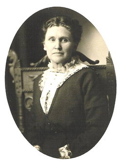

Margaret Ann Robinson Miles
| Birth | : | 21 Sep 1859 Springfield Township, Henry County, Missouri, USA |
| Death | : | 9 Dec 1932 Boulder County, Colorado, USA |
| Burial | : | Forest Lawn Memorial Park, Omaha, Douglas County, USA |
| Coordinate | : | 41.3272018, -95.9847031 |
| Description | : | Margaret married William Miles in Monroe County, Iowa March 19, 1878. According to census records they were residing in Rio Grande County by 1900. 1920 census records show Miles and Margaret living in Altona, Boulder County. Of this union 7 known children were born: David Earl b.1880, Mary Alice b.1884, George Franklin b.1887, James Leroy b.1889, William Carl b.1891, Nellie V. b.1894 and Eual b.1898. (Nelia Beamer was Margaret's younger sister.) |
frequently asked questions (FAQ):
-
Where is Margaret Ann Robinson Miles's memorial?
Margaret Ann Robinson Miles's memorial is located at: Forest Lawn Memorial Park, Omaha, Douglas County, USA.
-
When did Margaret Ann Robinson Miles death?
Margaret Ann Robinson Miles death on 9 Dec 1932 in Boulder County, Colorado, USA
-
Where are the coordinates of the Margaret Ann Robinson Miles's memorial?
Latitude: 41.3272018
Longitude: -95.9847031
Family Members:
Parent

Spouse
Siblings

Children
Flowers:


Nearby Cemetories:
1. Forest Lawn Memorial Park
Omaha, Douglas County, USA
Coordinate: 41.3272018, -95.9847031
2. Potter Field
Omaha, Douglas County, USA
Coordinate: 41.3320274, -95.9902878
3. Pleasant Hill Jewish Cemetery
Omaha, Douglas County, USA
Coordinate: 41.3185997, -95.9766998
4. Mormon Pioneer Cemetery
Omaha, Douglas County, USA
Coordinate: 41.3348450, -95.9663720
5. Golden Hill Cemetery
Omaha, Douglas County, USA
Coordinate: 41.3050003, -95.9744034
6. Springwell Cemetery
Omaha, Douglas County, USA
Coordinate: 41.3114014, -96.0096970
7. Mount Sinai Cemetery
Omaha, Douglas County, USA
Coordinate: 41.3116989, -96.0314026
8. Servants of Mary Cemetery
Omaha, Douglas County, USA
Coordinate: 41.3017170, -96.0258260
9. Mount Hope Cemetery
Omaha, Douglas County, USA
Coordinate: 41.3041992, -96.0310974
10. Prospect Hill Cemetery
Omaha, Douglas County, USA
Coordinate: 41.2780991, -95.9593964
11. Nash Chapel Crypt
Omaha, Douglas County, USA
Coordinate: 41.2665090, -95.9721790
12. Union Memorial Cemetery
Omaha, Douglas County, USA
Coordinate: 41.3512611, -96.0620193
13. Shipley Cemetery
Washington County, USA
Coordinate: 41.3932991, -95.9828033
14. First Central Congregational Columbarium
Omaha, Douglas County, USA
Coordinate: 41.2563456, -95.9658365
15. Holy Sepulchre Cemetery
Omaha, Douglas County, USA
Coordinate: 41.2543983, -95.9875031
16. All Saints Episcopal Church Columbarium
Omaha, Douglas County, USA
Coordinate: 41.2785000, -96.0579000
17. Trinity Cathedral Columbarium
Omaha, Douglas County, USA
Coordinate: 41.2603900, -95.9393660
18. Douglas County Poor Farm Cemetery
Omaha, Douglas County, USA
Coordinate: 41.2437240, -95.9723480
19. Bohemian Cemetery
Omaha, Douglas County, USA
Coordinate: 41.2388992, -95.9955978
20. Ak-Sar-Ben Racetrack Grounds
Omaha, Douglas County, USA
Coordinate: 41.2414703, -96.0159607
21. Saint Andrews Episcopal Church Columbarium
Omaha, Douglas County, USA
Coordinate: 41.2492500, -96.0427500
22. Countryside Community Church Columbarium
Omaha, Douglas County, USA
Coordinate: 41.2483660, -96.0500270
23. Westlawn-Hillcrest Memorial Park
Omaha, Douglas County, USA
Coordinate: 41.2346992, -95.9966965
24. Evergreen Memorial Park Cemetery
Omaha, Douglas County, USA
Coordinate: 41.2393990, -96.0355988