
| Birth | : | 3 May 1866 |
| Death | : | Jun 1942 |
| Burial | : | St. Peter & St. Paul's Parish Churchyard, Cosgrove, South Northamptonshire Borough, England |
| Coordinate | : | 52.0748600, -0.8474600 |
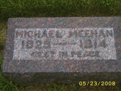
| Description | : | MICHAEL MEEHAN & ANNA KINNEY |
frequently asked questions (FAQ):
-
Where is Margaret Mary Meehan McGrail's memorial?
Margaret Mary Meehan McGrail's memorial is located at: St. Peter & St. Paul's Parish Churchyard, Cosgrove, South Northamptonshire Borough, England.
-
When did Margaret Mary Meehan McGrail death?
Margaret Mary Meehan McGrail death on Jun 1942 in
-
Where are the coordinates of the Margaret Mary Meehan McGrail's memorial?
Latitude: 52.0748600
Longitude: -0.8474600
Family Members:
Parent
Spouse

Siblings
Children
Flowers:


Nearby Cemetories:
1. St. Peter & St. Paul's Parish Churchyard
Cosgrove, South Northamptonshire Borough, England
Coordinate: 52.0748600, -0.8474600
2. Holy Trinity Churchyard
Wolverton, Milton Keynes Borough, England
Coordinate: 52.0642500, -0.8297700
3. St Mary Magdalen Churchyard
Stony Stratford, Milton Keynes Borough, England
Coordinate: 52.0587470, -0.8550560
4. St. Mary and St. Giles Churchyard
Stony Stratford, Milton Keynes Borough, England
Coordinate: 52.0569580, -0.8535910
5. St. Simon & St. Jude Churchyard
Castlethorpe, Milton Keynes Borough, England
Coordinate: 52.0931117, -0.8349450
6. Calverton Road Cemetery
Stony Stratford, Milton Keynes Borough, England
Coordinate: 52.0534300, -0.8511800
7. London Road Cemetery
Stony Stratford, Milton Keynes Borough, England
Coordinate: 52.0529290, -0.8439400
8. Wolverton Cemetery
Wolverton, Milton Keynes Borough, England
Coordinate: 52.0578540, -0.8184220
9. Potterspury Cemetery
Potterspury, South Northamptonshire Borough, England
Coordinate: 52.0803020, -0.8898052
10. United Reformed Church
Potterspury, South Northamptonshire Borough, England
Coordinate: 52.0836703, -0.8887879
11. St George the Martyr Churchyard
Wolverton, Milton Keynes Borough, England
Coordinate: 52.0622410, -0.8075220
12. St. Guthlac's Churchyard
Milton Keynes Borough, England
Coordinate: 52.0483770, -0.8634780
13. St Guthlac's Church Passenham
Old Stratford, South Northamptonshire Borough, England
Coordinate: 52.0481170, -0.8634000
14. All Saints Churchyard
Calverton, Milton Keynes Borough, England
Coordinate: 52.0439000, -0.8492000
15. St Leonards Church
Yardley Gobion, South Northamptonshire Borough, England
Coordinate: 52.0962081, -0.8844584
16. St. Mary's Churchyard
Milton Keynes Borough, England
Coordinate: 52.0769923, -0.7933094
17. St. James Ecumenical Churchyard
New Bradwell, Milton Keynes Borough, England
Coordinate: 52.0651300, -0.7935050
18. Holy Trinity Churchyard
Deanshanger, South Northamptonshire Borough, England
Coordinate: 52.0493600, -0.8907600
19. St James the Great Churchyard
Hanslope, Milton Keynes Borough, England
Coordinate: 52.1129940, -0.8274720
20. St Peter's Churchyard
Milton Keynes, Milton Keynes Borough, England
Coordinate: 52.0767000, -0.7821000
21. St Peter's Church
Stantonbury, Milton Keynes Borough, England
Coordinate: 52.0766920, -0.7820570
22. St Lawrence's Churchyard
Bradwell, Milton Keynes Borough, England
Coordinate: 52.0474500, -0.7891000
23. New Bradwell Cemetery
Stantonbury, Milton Keynes Borough, England
Coordinate: 52.0684700, -0.7743500
24. St John the Evangelist Churchyard
Wicken, South Northamptonshire Borough, England
Coordinate: 52.0489000, -0.9149000