
| Birth | : | 23 Jun 1905 Chetopa, Labette County, Kansas, USA |
| Death | : | 17 Jun 1997 Topeka, Shawnee County, Kansas, USA |
| Burial | : | Memorial Park Cemetery, Lawrence, Douglas County, USA |
| Coordinate | : | 38.9552994, -95.2153015 |
| Plot | : | Orchard Lawn, Lot 18, g 1P2 |
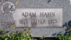
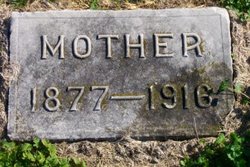
| Description | : | Private family services for Marguerite V. (Peg) Hazard, 91, Topeka, will be held at Memorial Park Cemetery, Lawrence. Burial will be at Memorial Park Cemetery. Mrs. Hazard died Tuesday, June 17, 1997, at a Topeka nursing center. She was born June 23, 1905, in Chetopa, the daughter of Adam and Margaret Burns Hahn. She married Stuart G. Hazard on Sept. 15, 1929. He died Aug. 3, 1996. She was a member of Central Congregational Church, Topeka, for 67 years. Survivors include a son, Stuart G. Hazard Jr., Topeka; a daughter, Margaret Elizabeth Beers, Topeka; five grandsons and nine great grandchildren. Thursday, June 19, 1997 ljworld |
frequently asked questions (FAQ):
-
Where is Marguerite Violet “Peg” Hahn Hazard's memorial?
Marguerite Violet “Peg” Hahn Hazard's memorial is located at: Memorial Park Cemetery, Lawrence, Douglas County, USA.
-
When did Marguerite Violet “Peg” Hahn Hazard death?
Marguerite Violet “Peg” Hahn Hazard death on 17 Jun 1997 in Topeka, Shawnee County, Kansas, USA
-
Where are the coordinates of the Marguerite Violet “Peg” Hahn Hazard's memorial?
Latitude: 38.9552994
Longitude: -95.2153015
Family Members:
Parent
Spouse

Siblings
Children
Flowers:


Nearby Cemetories:
1. Memorial Park Cemetery
Lawrence, Douglas County, USA
Coordinate: 38.9552994, -95.2153015
2. Mount Calvary Catholic Cemetery
Lawrence, Douglas County, USA
Coordinate: 38.9580002, -95.2139969
3. Oak Hill Cemetery
Lawrence, Douglas County, USA
Coordinate: 38.9589005, -95.2118988
4. Trinity Episcopal Church Columbarium
Lawrence, Douglas County, USA
Coordinate: 38.9653893, -95.2373886
5. Saint Johns Catholic Cemetery
Douglas County, USA
Coordinate: 38.9437900, -95.1919600
6. Dyche Hall Natural History Museum
Lawrence, Douglas County, USA
Coordinate: 38.9584800, -95.2434800
7. Haskell Cemetery
Lawrence, Douglas County, USA
Coordinate: 38.9353790, -95.2284241
8. Franklin Cemetery
Douglas County, USA
Coordinate: 38.9437523, -95.1869431
9. Pioneer Cemetery
Lawrence, Douglas County, USA
Coordinate: 38.9528008, -95.2611008
10. First Presbyterian Church Memorial Garden
Lawrence, Douglas County, USA
Coordinate: 38.9414900, -95.2641600
11. County Poor Farm Cemetery
Douglas County, USA
Coordinate: 38.9119400, -95.2214600
12. Kennedy Cemetery
Douglas County, USA
Coordinate: 38.9112900, -95.2269200
13. Maple Grove Cemetery
Lawrence, Douglas County, USA
Coordinate: 39.0018997, -95.2316971
14. Adams Cemetery
Douglas County, USA
Coordinate: 38.9955400, -95.2509100
15. Blue Mound Cemetery
Lawrence, Douglas County, USA
Coordinate: 38.9046600, -95.1865400
16. Davis Cemetery
Lawrence, Douglas County, USA
Coordinate: 38.9722500, -95.2831100
17. Marshall Cemetery
Douglas County, USA
Coordinate: 38.9040800, -95.2446700
18. Dutton Cemetery
Douglas County, USA
Coordinate: 38.8989800, -95.2790600
19. Luckan Family Cemetery
Fall Leaf, Leavenworth County, USA
Coordinate: 38.9808500, -95.1128000
20. Corpus Christi Catholic Church Columbarium
Lawrence, Douglas County, USA
Coordinate: 38.9572250, -95.3238450
21. Cemetery Beni Israel
Eudora, Douglas County, USA
Coordinate: 38.9280128, -95.1122208
22. Lyon Family Cemetery
Lawrence, Douglas County, USA
Coordinate: 38.9877440, -95.3166530
23. Richland Cemetery
Lawrence, Douglas County, USA
Coordinate: 38.8768997, -95.2630997
24. Southwest City Cemetery
Eudora, Douglas County, USA
Coordinate: 38.9334800, -95.1070300