

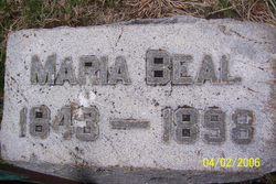
Maria Stephens Beal
| Birth | : | 1843 Clinton County, Ohio, USA |
| Death | : | 1898 Greene County, Ohio, USA |
| Burial | : | St. Michael and All Angels Churchyard, Cuxton, Medway Unitary Authority, England |
| Coordinate | : | 51.3714120, 0.4546760 |
| Plot | : | Sect. A |
| Inscription | : | Maria Beal 1843 - 1898 |
frequently asked questions (FAQ):
-
Where is Maria Stephens Beal's memorial?
Maria Stephens Beal's memorial is located at: St. Michael and All Angels Churchyard, Cuxton, Medway Unitary Authority, England.
-
When did Maria Stephens Beal death?
Maria Stephens Beal death on 1898 in Greene County, Ohio, USA
-
Where are the coordinates of the Maria Stephens Beal's memorial?
Latitude: 51.3714120
Longitude: 0.4546760
Family Members:
Parent

Spouse
Siblings
Children
Flowers:


Nearby Cemetories:
1. St. Michael and All Angels Churchyard
Cuxton, Medway Unitary Authority, England
Coordinate: 51.3714120, 0.4546760
2. All Saints Churchyard
Wouldham, Tonbridge and Malling Borough, England
Coordinate: 51.3528130, 0.4580580
3. St Matthew Churchyard
Borstal, Medway Unitary Authority, England
Coordinate: 51.3736150, 0.4868020
4. Halling War Memorial
Halling, Medway Unitary Authority, England
Coordinate: 51.3519630, 0.4439060
5. Halling Church Cemetery
Halling, Medway Unitary Authority, England
Coordinate: 51.3499140, 0.4447960
6. St John the Baptist Churchyard
Halling, Medway Unitary Authority, England
Coordinate: 51.3484993, 0.4468510
7. Strood Cemetery
Strood, Medway Unitary Authority, England
Coordinate: 51.3900220, 0.4838640
8. St. Margaret's Cemetery
Rochester, Medway Unitary Authority, England
Coordinate: 51.3777000, 0.5011600
9. St. Nicholas's Cemetery
Rochester, Medway Unitary Authority, England
Coordinate: 51.3780081, 0.5021076
10. St Margaret Churchyard
Rochester, Medway Unitary Authority, England
Coordinate: 51.3849380, 0.4993630
11. St Nicholas with St Mary Churchyard
Strood, Medway Unitary Authority, England
Coordinate: 51.3959790, 0.4931350
12. Rochester Castle Moat Burial Ground
Rochester, Medway Unitary Authority, England
Coordinate: 51.3894140, 0.5024580
13. Rochester Cathedral
Rochester, Medway Unitary Authority, England
Coordinate: 51.3889750, 0.5031160
14. Rochester Baptist Church
Rochester, Medway Unitary Authority, England
Coordinate: 51.3871570, 0.5052370
15. St Nicholas Churchyard
Rochester, Medway Unitary Authority, England
Coordinate: 51.3894170, 0.5035320
16. St Peter and St Paul Churchyard
Luddesdown, Gravesham Borough, England
Coordinate: 51.3700218, 0.3974010
17. Fort Pitt Military Cemetery
Rochester, Medway Unitary Authority, England
Coordinate: 51.3769790, 0.5114570
18. Cobham War Memorial
Cobham, Gravesham Borough, England
Coordinate: 51.3900719, 0.4043670
19. St. Mary Magdalene New Churchyard
Cobham, Gravesham Borough, England
Coordinate: 51.3899060, 0.3983090
20. Snodland Cemetery
Snodland, Tonbridge and Malling Borough, England
Coordinate: 51.3336110, 0.4348770
21. St Mary Old Churchyard
Burham, Tonbridge and Malling Borough, England
Coordinate: 51.3312262, 0.4619326
22. Burham War Memorial
Burham, Tonbridge and Malling Borough, England
Coordinate: 51.3327530, 0.4785610
23. All Saints Churchyard
Snodland, Tonbridge and Malling Borough, England
Coordinate: 51.3299000, 0.4496900
24. Chatham Unitarian Church
Chatham, Medway Unitary Authority, England
Coordinate: 51.3826090, 0.5195850