
| Birth | : | 8 May 1909 Hamilton County, Nebraska, USA |
| Death | : | 8 Dec 2005 Omaha, Douglas County, Nebraska, USA |
| Burial | : | St. Peter's Churchyard, Norton Disney, North Kesteven District, England |
| Coordinate | : | 53.1203000, -0.6717000 |
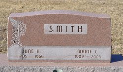
| Description | : | Marie C. Smith, daughter of Merton and Mary Elena (Hill) Jeffers was born May 8, 1909 in Hamilton County. She attended school in Hamilton and Custer counties. She married June H. Smith Feb. 8, 1920 in Nelson. They farmed in Hamilton County until 1955 when they moved into Aurora. She was manager of the Woodbine Apartments for several years. Her husband died March 27, 1966. She had been a member of the United Methodist Church in Aurora. Survivors include her daughter, Patty (Jerry) Seerden of Meridian, Idaho; two grandchildren, two great-grandchildren and many nieces and nephews. She was preceded in... Read More |
frequently asked questions (FAQ):
-
Where is Marie C. Jeffers Smith's memorial?
Marie C. Jeffers Smith's memorial is located at: St. Peter's Churchyard, Norton Disney, North Kesteven District, England.
-
When did Marie C. Jeffers Smith death?
Marie C. Jeffers Smith death on 8 Dec 2005 in Omaha, Douglas County, Nebraska, USA
-
Where are the coordinates of the Marie C. Jeffers Smith's memorial?
Latitude: 53.1203000
Longitude: -0.6717000
Family Members:
Parent
Spouse
Siblings
Flowers:


Nearby Cemetories:
1. St. Peter's Churchyard
Norton Disney, North Kesteven District, England
Coordinate: 53.1203000, -0.6717000
2. St Peter's Churchyard
Norton Disney, North Kesteven District, England
Coordinate: 53.1203200, -0.6716900
3. St Michael's Church
Norton Disney, North Kesteven District, England
Coordinate: 53.1204000, -0.6795000
4. All Saints Churchyard
Stapleford, North Kesteven District, England
Coordinate: 53.1082000, -0.6776500
5. St. Michael's Churchyard
Bassingham, North Kesteven District, England
Coordinate: 53.1265350, -0.6431400
6. Newark Road Cemetery
Bassingham, North Kesteven District, England
Coordinate: 53.1265300, -0.6429400
7. St Mary's Churchyard
Carlton-le-Moorland, North Kesteven District, England
Coordinate: 53.1107500, -0.6449000
8. St Germain Churchyard
Thurlby, South Kesteven District, England
Coordinate: 53.1447870, -0.6425330
9. St Peter Churchyard
Aubourn, North Kesteven District, England
Coordinate: 53.1518050, -0.6264200
10. All Saints' Churchyard
Swinderby, North Kesteven District, England
Coordinate: 53.1587100, -0.7017900
11. All Saints Churchyard
Beckingham, North Kesteven District, England
Coordinate: 53.0740990, -0.6945420
12. St Helen's Churchyard
Brant Broughton, North Kesteven District, England
Coordinate: 53.0744850, -0.6351690
13. St Helena Churchyard
South Scarle, Newark and Sherwood District, England
Coordinate: 53.1665600, -0.7326100
14. St. John the Baptist Churchyard
Collingham, Newark and Sherwood District, England
Coordinate: 53.1425550, -0.7656640
15. Collingham North All Saints Churchyard
Collingham, Newark and Sherwood District, England
Coordinate: 53.1490600, -0.7607900
16. Saint Michael and All Angels Churchyard
Thorpe-on-the-Hill, North Kesteven District, England
Coordinate: 53.1784800, -0.6418800
17. St Bartholomew Churchyard
Langford, Newark and Sherwood District, England
Coordinate: 53.1225760, -0.7743940
18. St Michael Churchyard
Stragglethorpe, North Kesteven District, England
Coordinate: 53.0609600, -0.6382370
19. Saint Michael's Churchyard
South Hykeham, North Kesteven District, England
Coordinate: 53.1696789, -0.5998978
20. North Hykeham Cemetery
North Hykeham, North Kesteven District, England
Coordinate: 53.1746720, -0.5987370
21. All Saints Churchyard
Winthorpe, Newark and Sherwood District, England
Coordinate: 53.0983646, -0.7884366
22. All Saints Churchyard
Fenton, South Kesteven District, England
Coordinate: 53.0462300, -0.6910100
23. All Saints Churchyard
Eagle, North Kesteven District, England
Coordinate: 53.1947490, -0.6904180
24. Holy Trinity Churchyard
Besthorpe, Newark and Sherwood District, England
Coordinate: 53.1731600, -0.7664200