


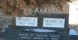
Marie Danzer Huckfeldt
| Birth | : | 13 Mar 1914 Fort Pierre, Stanley County, South Dakota, USA |
| Death | : | 11 Mar 2011 South Dakota, USA |
| Burial | : | Scotty Philip Cemetery, Fort Pierre, Stanley County, USA |
| Coordinate | : | 44.4019012, -100.4036026 |
| Plot | : | Section 1 Lot 79 Grave 6 |
| Description | : | Marie Danzer Huckfeldt, 96, Custer and formerly of Fort Pierre, passed away March 11, 2011. Marie was born March 13, 1914, to Michael and Frances (Schnelldorfer) Danzer at their home in rural Fort Pierre. She attended rural school in Stanley County. On Sept. 10, 1937, she married Henry J. Huckfeldt, also of rural Fort Pierre. They owned and operated a cattle ranch along the Missouri River at historic Stoney Point. She moved to Rapid City in April 2003 to live near her daughter, Kathryn Brewer. Marie will be especially remembered for her garden, country fried chicken, homemade wild fruit jelly,... Read More |
frequently asked questions (FAQ):
-
Where is Marie Danzer Huckfeldt's memorial?
Marie Danzer Huckfeldt's memorial is located at: Scotty Philip Cemetery, Fort Pierre, Stanley County, USA.
-
When did Marie Danzer Huckfeldt death?
Marie Danzer Huckfeldt death on 11 Mar 2011 in South Dakota, USA
-
Where are the coordinates of the Marie Danzer Huckfeldt's memorial?
Latitude: 44.4019012
Longitude: -100.4036026
Family Members:
Spouse
Flowers:


Nearby Cemetories:
1. Scotty Philip Cemetery
Fort Pierre, Stanley County, USA
Coordinate: 44.4019012, -100.4036026
2. Fort Pierre Chouteau Cemetery
Fort Pierre, Stanley County, USA
Coordinate: 44.3908700, -100.3878300
3. Mount Calvary Cemetery
Pierre, Hughes County, USA
Coordinate: 44.4197006, -100.3557968
4. South Dakota State Capitol Grounds
Pierre, Hughes County, USA
Coordinate: 44.3660100, -100.3448000
5. Cedar Hill Cemetery
Fort Pierre, Stanley County, USA
Coordinate: 44.3356018, -100.3964005
6. Riverside Cemetery
Pierre, Hughes County, USA
Coordinate: 44.3608017, -100.3071976
7. Byron Township Cemetery
Blunt, Hughes County, USA
Coordinate: 44.4979200, -100.1904700
8. Fort Sully Post Cemetery
Sully County, USA
Coordinate: 44.5866480, -100.6087530
9. Meers Cemetery
Stanley County, USA
Coordinate: 44.4116970, -100.7360760
10. Mathews Family Cemetery
Stanley County, USA
Coordinate: 44.1816040, -100.5581080
11. Okobojo Cemetery
Sully County, USA
Coordinate: 44.6568985, -100.3647003
12. Canning Cemetery
Hughes County, USA
Coordinate: 44.3986890, -100.0278460
13. Holy Name Episcopal Cemetery
Fort Pierre, Stanley County, USA
Coordinate: 44.2694960, -100.0357300
14. Holy Name Chapel Cemetery
Fort Pierre, Stanley County, USA
Coordinate: 44.2694292, -100.0356989
15. Pleasant Hill Cemetery
Blunt, Hughes County, USA
Coordinate: 44.5135994, -100.0156021
16. Fort Bennett Post Cemetery
Stanley County, USA
Coordinate: 44.6716500, -100.6404200
17. Immanuel Lutheran Cemetery
Van Metre, Jones County, USA
Coordinate: 44.0958800, -100.7263300
18. Mission Ridge Cemetery
Mission Ridge, Stanley County, USA
Coordinate: 44.6960983, -100.7716980
19. Onida Cemetery
Onida, Sully County, USA
Coordinate: 44.7147000, -100.0650000
20. Chapelle Cemetery
Hughes County, USA
Coordinate: 44.3025017, -99.8653030
21. Holy Faith Cemetery
Lyman County, USA
Coordinate: 44.1356010, -99.9878006
22. Blair Cemetery
Sully County, USA
Coordinate: 44.8027992, -100.4199982
23. Sansarc Cemetery
Hayes, Stanley County, USA
Coordinate: 44.5153008, -101.0342026
24. Draper Cemetery
Draper, Jones County, USA
Coordinate: 43.9322014, -100.5475006