

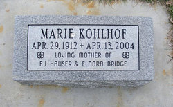
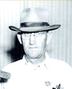
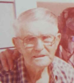
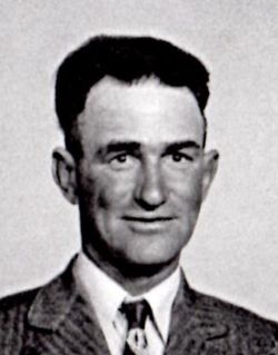
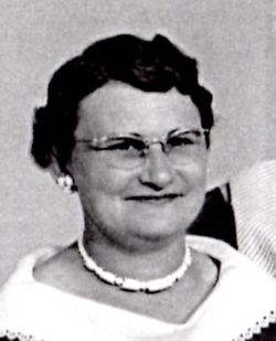
Marie Louise Obermiller Kohlhof
| Birth | : | 29 Apr 1912 Loup City, Sherman County, Nebraska, USA |
| Death | : | 13 Apr 2004 Scottsbluff, Scotts Bluff County, Nebraska, USA |
| Burial | : | Ilchester Gallows Field Cemetery, Ilchester, South Somerset District, England |
| Coordinate | : | 50.9996250, -2.6831080 |
| Description | : | Married Paul William Kohlhof in Rushville, Nebraska in 1959. Sister Dorothy was her twin. |
frequently asked questions (FAQ):
-
Where is Marie Louise Obermiller Kohlhof's memorial?
Marie Louise Obermiller Kohlhof's memorial is located at: Ilchester Gallows Field Cemetery, Ilchester, South Somerset District, England.
-
When did Marie Louise Obermiller Kohlhof death?
Marie Louise Obermiller Kohlhof death on 13 Apr 2004 in Scottsbluff, Scotts Bluff County, Nebraska, USA
-
Where are the coordinates of the Marie Louise Obermiller Kohlhof's memorial?
Latitude: 50.9996250
Longitude: -2.6831080
Family Members:
Parent
Spouse
Siblings

Children

Flowers:


Nearby Cemetories:
1. Ilchester Gallows Field Cemetery
Ilchester, South Somerset District, England
Coordinate: 50.9996250, -2.6831080
2. St Mary Major Churchyard
Ilchester, South Somerset District, England
Coordinate: 51.0010030, -2.6818120
3. Ilchester County Gaol Cemetery
Ilchester, South Somerset District, England
Coordinate: 51.0023060, -2.6833610
4. St Andrew Churchyard
Ilchester, South Somerset District, England
Coordinate: 51.0056950, -2.6804910
5. Ilchester Parish Cemetery
Ilchester, South Somerset District, England
Coordinate: 50.9993670, -2.6721280
6. Saint Mary Churchyard
Limington, South Somerset District, England
Coordinate: 50.9989000, -2.6546000
7. Blessed Virgin Mary Churchyard
Chilthorne Domer, South Somerset District, England
Coordinate: 50.9721100, -2.6783950
8. St. Peter’s Churchyard
Podimore, South Somerset District, England
Coordinate: 51.0219250, -2.6492310
9. All Saints Churchyard
Kingsdon, South Somerset District, England
Coordinate: 51.0330100, -2.6918330
10. St Vincent Churchyard
Ashington, South Somerset District, England
Coordinate: 50.9904090, -2.6267630
11. St. James Parish Churchyard
Chilton Cantelo, South Somerset District, England
Coordinate: 50.9972730, -2.6136800
12. Holy Trinity Churchyard
Ash, South Somerset District, England
Coordinate: 50.9834250, -2.7528400
13. Ash Parish Cemetery
Ash, South Somerset District, England
Coordinate: 50.9833540, -2.7538380
14. Lufton Anglican Churchyard
Lufton, South Somerset District, England
Coordinate: 50.9491080, -2.6917910
15. Christ Church Cemetery
Long Load, South Somerset District, England
Coordinate: 51.0054700, -2.7639100
16. Blessed Virgin Mary Churchyard
Mudford, South Somerset District, England
Coordinate: 50.9773210, -2.6086310
17. Church of the Virgin Mary
Charlton Mackrell, South Somerset District, England
Coordinate: 51.0524210, -2.6743894
18. Holy Trinity Churchyard
Long Sutton, South Somerset District, England
Coordinate: 51.0246110, -2.7577940
19. Mudford Parish Cemetery
Mudford, South Somerset District, England
Coordinate: 50.9708040, -2.6114880
20. St. Catherine's Churchyard
Montacute, South Somerset District, England
Coordinate: 50.9495420, -2.7178200
21. Montacute Priory
Montacute, South Somerset District, England
Coordinate: 50.9489820, -2.7183880
22. St. Peter & St. Paul's Churchyard
Charlton Adam, South Somerset District, England
Coordinate: 51.0552350, -2.6647930
23. St. James's Churchyard
Preston Plucknett, South Somerset District, England
Coordinate: 50.9437800, -2.6635960
24. Long Sutton Friends Burial Ground
Long Sutton, South Somerset District, England
Coordinate: 51.0302700, -2.7612300