
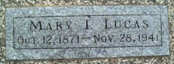
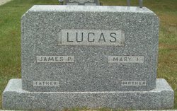
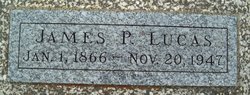
Marietta Isabella “Mary” Gray Lucas
| Birth | : | 12 Oct 1871 Olive Township, Noble County, Ohio, USA |
| Death | : | 28 Nov 1941 Butler County, Kansas, USA |
| Burial | : | Blessed Virgin Mary Churchyard, Shapwick, Sedgemoor District, England |
| Coordinate | : | 51.1405090, -2.8336100 |
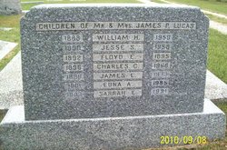
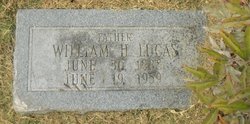
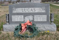
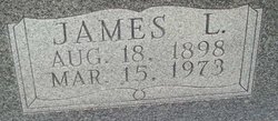
| Inscription | : | Mother Children of Mr. and Mrs. James P. Lucas William H. 1888 - 1959 Jesse S. 1890 - 1958 Floyd E. 1892 - 1895 Charles C. 1896 - 1968 James L. 1898 - 1973 Edna A. 1901 - 1985 |
frequently asked questions (FAQ):
-
Where is Marietta Isabella “Mary” Gray Lucas's memorial?
Marietta Isabella “Mary” Gray Lucas's memorial is located at: Blessed Virgin Mary Churchyard, Shapwick, Sedgemoor District, England.
-
When did Marietta Isabella “Mary” Gray Lucas death?
Marietta Isabella “Mary” Gray Lucas death on 28 Nov 1941 in Butler County, Kansas, USA
-
Where are the coordinates of the Marietta Isabella “Mary” Gray Lucas's memorial?
Latitude: 51.1405090
Longitude: -2.8336100
Family Members:
Parent

Spouse
Siblings
Children

Flowers:


Nearby Cemetories:
1. Blessed Virgin Mary Churchyard
Shapwick, Sedgemoor District, England
Coordinate: 51.1405090, -2.8336100
2. St. Michael and All Angels Churchyard
Greinton, Sedgemoor District, England
Coordinate: 51.1240140, -2.8408590
3. All Saint's Churchyard
Ashcott, Sedgemoor District, England
Coordinate: 51.1309220, -2.8058870
4. Blessed Virgin Mary Churchyard
Moorlinch, Sedgemoor District, England
Coordinate: 51.1280000, -2.8616000
5. Saint Peter Churchyard
Catcott, Sedgemoor District, England
Coordinate: 51.1494920, -2.8671220
6. Saint George Churchyard
Edington, Sedgemoor District, England
Coordinate: 51.1540010, -2.8778350
7. Sutton Mallet Churchyard
Sutton Mallet, Sedgemoor District, England
Coordinate: 51.1282540, -2.8974536
8. St Edwards Churchyard
Chilton Polden, Sedgemoor District, England
Coordinate: 51.1554490, -2.8972091
9. Holy Trinity Churchyard
Walton, Mendip District, England
Coordinate: 51.1236200, -2.7709580
10. Holy Trinity Churchyard Extension
Walton, Mendip District, England
Coordinate: 51.1234150, -2.7695832
11. St. Francis Churchyard
Stawell, Sedgemoor District, England
Coordinate: 51.1404200, -2.9046660
12. St. Mary & All Saints Churchyard
Meare, Mendip District, England
Coordinate: 51.1715900, -2.7804100
13. St. Philip and St. James Churchyard
Burtle, Sedgemoor District, England
Coordinate: 51.1856232, -2.8665409
14. Street Cemetery
Street, Mendip District, England
Coordinate: 51.1302840, -2.7508240
15. St. Mary's Churchyard
Cossington, Sedgemoor District, England
Coordinate: 51.1580085, -2.9213149
16. Holy Cross Churchyard
Middlezoy, Sedgemoor District, England
Coordinate: 51.0937200, -2.8941260
17. Religious Society of Friends Quaker Cemetery
Street, Mendip District, England
Coordinate: 51.1294100, -2.7375630
18. Holy Trinity Churchyard
Street, Mendip District, England
Coordinate: 51.1310100, -2.7330800
19. St. Andrew's Churchyard
High Ham, South Somerset District, England
Coordinate: 51.0760320, -2.8218400
20. Westonzoyland Cemetery
Westonzoyland, Sedgemoor District, England
Coordinate: 51.1078900, -2.9264440
21. St. Mary's Churchyard
Westonzoyland, Sedgemoor District, England
Coordinate: 51.1087000, -2.9273800
22. High Ham Cemetery
High Ham, South Somerset District, England
Coordinate: 51.0739931, -2.8216351
23. The Old Chapel
Westonzoyland, Sedgemoor District, England
Coordinate: 51.1077425, -2.9285237
24. Church of the Blessed Virgin Mary Churchyard
Chedzoy, Sedgemoor District, England
Coordinate: 51.1344600, -2.9429400