
| Birth | : | 11 Jul 1934 De Smet, Kingsbury County, South Dakota, USA |
| Death | : | 30 Jun 2020 Pierre, Hughes County, South Dakota, USA |
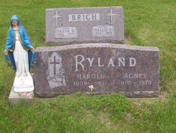
| Burial | : | Riverside Cemetery, Pierre, Hughes County, USA |
| Coordinate | : | 44.3608017, -100.3071976 |
| Description | : | Marilyn was born on July 11, 1934, to Harold and Agnes (Bunker) Ryland in DeSmet, SD. She grew up and graduated high school in DeSmet. She met Roland Cromwell and they got married in Pipestone, MN on September 1st, 1955. In 1961 Marilyn and Roland made there home in Pierre, SD. After they moved to Pierre Marilyn worked in the Hughes County Auditors office for 30 years. When she retired, she worked at the Boys and Girls Club in Pierre and the Community Youth Center in Fort Pierre. Marilyn lived for her children and grandchildren. She liked country... Read More |
frequently asked questions (FAQ):
-
Where is Marilyn Jean Ryland Cromwell's memorial?
Marilyn Jean Ryland Cromwell's memorial is located at: Riverside Cemetery, Pierre, Hughes County, USA.
-
When did Marilyn Jean Ryland Cromwell death?
Marilyn Jean Ryland Cromwell death on 30 Jun 2020 in Pierre, Hughes County, South Dakota, USA
-
Where are the coordinates of the Marilyn Jean Ryland Cromwell's memorial?
Latitude: 44.3608017
Longitude: -100.3071976
Family Members:
Parent

Spouse

Siblings
Flowers:


Nearby Cemetories:
1. Riverside Cemetery
Pierre, Hughes County, USA
Coordinate: 44.3608017, -100.3071976
2. South Dakota State Capitol Grounds
Pierre, Hughes County, USA
Coordinate: 44.3660100, -100.3448000
3. Fort Pierre Chouteau Cemetery
Fort Pierre, Stanley County, USA
Coordinate: 44.3908700, -100.3878300
4. Mount Calvary Cemetery
Pierre, Hughes County, USA
Coordinate: 44.4197006, -100.3557968
5. Cedar Hill Cemetery
Fort Pierre, Stanley County, USA
Coordinate: 44.3356018, -100.3964005
6. Scotty Philip Cemetery
Fort Pierre, Stanley County, USA
Coordinate: 44.4019012, -100.4036026
7. Byron Township Cemetery
Blunt, Hughes County, USA
Coordinate: 44.4979200, -100.1904700
8. Canning Cemetery
Hughes County, USA
Coordinate: 44.3986890, -100.0278460
9. Holy Name Episcopal Cemetery
Fort Pierre, Stanley County, USA
Coordinate: 44.2694960, -100.0357300
10. Holy Name Chapel Cemetery
Fort Pierre, Stanley County, USA
Coordinate: 44.2694292, -100.0356989
11. Mathews Family Cemetery
Stanley County, USA
Coordinate: 44.1816040, -100.5581080
12. Pleasant Hill Cemetery
Blunt, Hughes County, USA
Coordinate: 44.5135994, -100.0156021
13. Okobojo Cemetery
Sully County, USA
Coordinate: 44.6568985, -100.3647003
14. Meers Cemetery
Stanley County, USA
Coordinate: 44.4116970, -100.7360760
15. Fort Sully Post Cemetery
Sully County, USA
Coordinate: 44.5866480, -100.6087530
16. Holy Faith Cemetery
Lyman County, USA
Coordinate: 44.1356010, -99.9878006
17. Chapelle Cemetery
Hughes County, USA
Coordinate: 44.3025017, -99.8653030
18. Fort Bennett Post Cemetery
Stanley County, USA
Coordinate: 44.6716500, -100.6404200
19. Onida Cemetery
Onida, Sully County, USA
Coordinate: 44.7147000, -100.0650000
20. Immanuel Lutheran Cemetery
Van Metre, Jones County, USA
Coordinate: 44.0958800, -100.7263300
21. Saint Catherines Cemetery
Harrold, Hughes County, USA
Coordinate: 44.2091100, -99.7868200
22. Ascension Cemetery
Canning, Hughes County, USA
Coordinate: 44.1523700, -99.7927100
23. Medicine Hill Cemetery
Harrold, Hughes County, USA
Coordinate: 44.5116997, -99.7453003
24. Saint John Catholic Cemetery
Harrold, Hughes County, USA
Coordinate: 44.5127983, -99.7335968