
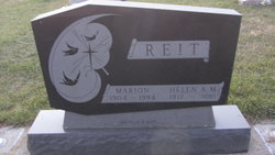
Marion “Mike” Reit
| Birth | : | 1 Aug 1904 South Dakota, USA |
| Death | : | 29 Jun 1994 South Dakota, USA |
| Burial | : | Immanuel Churchyard, Oswaldwistle, Hyndburn Borough, England |
| Coordinate | : | 53.7358300, -2.4056200 |
frequently asked questions (FAQ):
-
Where is Marion “Mike” Reit's memorial?
Marion “Mike” Reit's memorial is located at: Immanuel Churchyard, Oswaldwistle, Hyndburn Borough, England.
-
When did Marion “Mike” Reit death?
Marion “Mike” Reit death on 29 Jun 1994 in South Dakota, USA
-
Where are the coordinates of the Marion “Mike” Reit's memorial?
Latitude: 53.7358300
Longitude: -2.4056200
Family Members:
Parent
Spouse
Siblings

Flowers:


Nearby Cemetories:
1. Immanuel Churchyard
Oswaldwistle, Hyndburn Borough, England
Coordinate: 53.7358300, -2.4056200
2. New Lane Baptist Chapel Chapelyard
Oswaldwistle, Hyndburn Borough, England
Coordinate: 53.7381100, -2.4049500
3. St James Churchyard
Church, Hyndburn Borough, England
Coordinate: 53.7574640, -2.3942660
4. St. James' Parish Church
Accrington, Hyndburn Borough, England
Coordinate: 53.7519900, -2.3652600
5. Christ Church Churchyard
Accrington, Hyndburn Borough, England
Coordinate: 53.7478560, -2.3605820
6. Church and Clayton-le-Moors Cemetery
Accrington, Hyndburn Borough, England
Coordinate: 53.7630200, -2.3804820
7. St. John the Baptist Churchyard
Baxenden, Hyndburn Borough, England
Coordinate: 53.7346500, -2.3470230
8. Pickup Bank Congregational Chapel
Pickup Bank, Blackburn with Darwen Unitary Authority, England
Coordinate: 53.7012440, -2.4164220
9. St James Churchyard
Lower Darwen, Blackburn with Darwen Unitary Authority, England
Coordinate: 53.7245510, -2.4634700
10. Haslingden Grane Methodist Chapel Cemetery
Haslingden, Rossendale Borough, England
Coordinate: 53.7016300, -2.3728190
11. All Saints Churchyard
Clayton-le-Moors, Hyndburn Borough, England
Coordinate: 53.7738520, -2.3881690
12. Barnes Square Weslyan Methodist Churchyard
Clayton-le-Moors, Hyndburn Borough, England
Coordinate: 53.7744350, -2.3853800
13. St. Paul's Churchyard
Darwen, Blackburn with Darwen Unitary Authority, England
Coordinate: 53.6979270, -2.4318640
14. Accrington Cemetery and Crematorium
Accrington, Hyndburn Borough, England
Coordinate: 53.7623787, -2.3508649
15. Holy Trinity Church
Blackburn with Darwen Unitary Authority, England
Coordinate: 53.7511727, -2.4747178
16. Great Harwood Cemetery
Great Harwood, Hyndburn Borough, England
Coordinate: 53.7796190, -2.4091680
17. Mount St Presbyterian Chapelyard
Blackburn, Blackburn with Darwen Unitary Authority, England
Coordinate: 53.7478000, -2.4775000
18. St Alban's Churchyard
Blackburn, Blackburn with Darwen Unitary Authority, England
Coordinate: 53.7530090, -2.4748540
19. Blackburn Cathedral
Blackburn, Blackburn with Darwen Unitary Authority, England
Coordinate: 53.7472960, -2.4820020
20. Wesleyan Methodist Chapel Chapelyard
Blackburn, Blackburn with Darwen Unitary Authority, England
Coordinate: 53.7464910, -2.4848380
21. St Marys Burial Ground
Clayton-le-Moors, Hyndburn Borough, England
Coordinate: 53.7792778, -2.3705871
22. St. Peter's Churchyard
Blackburn, Blackburn with Darwen Unitary Authority, England
Coordinate: 53.7448110, -2.4865070
23. Independent Chapel Churchyard
Blackburn, Blackburn with Darwen Unitary Authority, England
Coordinate: 53.7454960, -2.4864460
24. Our Lady and Saint Hubert
Great Harwood, Hyndburn Borough, England
Coordinate: 53.7851070, -2.4009760