
| Birth | : | 29 Oct 1928 Claresholm Census Division, Alberta, Canada |
| Death | : | 17 Jan 2019 Vulcan, Strathmore Census Division, Alberta, Canada |
| Burial | : | Vulcan Cemetery, Vulcan, Strathmore Census Division, Canada |
| Coordinate | : | 50.4032200, -113.2774100 |
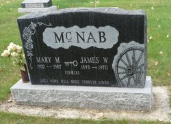
| Description | : | Vulcan Funeral Home - obit Marjorie Anna May McLennan October 29, 1928 to January 17, 2019 Marjorie (Marj) McLennan passed away peacefully at the age of 90 with her family by her side at Vulcan Extendicare. Marj was the third of nine children, born on a farm next to the Belly River, south-east of Fort Macleod, to James and Mary McNab. Marj was raised on the family farm and had many stories of going to the country school, tending gardens, riding horses, hauling water from the river and cooking with her mother. She was especially proud of the... Read More |
frequently asked questions (FAQ):
-
Where is Marjorie Anna May McNab McLennan's memorial?
Marjorie Anna May McNab McLennan's memorial is located at: Vulcan Cemetery, Vulcan, Strathmore Census Division, Canada.
-
When did Marjorie Anna May McNab McLennan death?
Marjorie Anna May McNab McLennan death on 17 Jan 2019 in Vulcan, Strathmore Census Division, Alberta, Canada
-
Where are the coordinates of the Marjorie Anna May McNab McLennan's memorial?
Latitude: 50.4032200
Longitude: -113.2774100
Family Members:
Parent

Spouse
Siblings
Flowers:


Nearby Cemetories:
1. Vulcan Cemetery
Vulcan, Strathmore Census Division, Canada
Coordinate: 50.4032200, -113.2774100
2. Highland Cemetery
Vulcan, Strathmore Census Division, Canada
Coordinate: 50.4845700, -113.2659100
3. Cleverville Cemetery
Champion, Strathmore Census Division, Canada
Coordinate: 50.2736100, -113.1661700
4. Reid Hill Cemetery
Vulcan, Strathmore Census Division, Canada
Coordinate: 50.3974000, -113.0295500
5. Brant Cemetery
Brant, Strathmore Census Division, Canada
Coordinate: 50.5067400, -113.5068000
6. Fath Hill Catholic Cemetery
Champion, Strathmore Census Division, Canada
Coordinate: 50.2153400, -113.2544200
7. Champion Cemetery
Champion, Strathmore Census Division, Canada
Coordinate: 50.2329200, -113.1441800
8. Sharon Cemetery
Brant, Strathmore Census Division, Canada
Coordinate: 50.4555300, -113.5740800
9. Little Bow Hutterite Cemetery
Stavely, Claresholm Census Division, Canada
Coordinate: 50.2142141, -113.3694417
10. Isol Russell Grave
Champion, Strathmore Census Division, Canada
Coordinate: 50.1792300, -113.2102100
11. Alston Cemetery
Vulcan, Strathmore Census Division, Canada
Coordinate: 50.1652820, -113.2450470
12. Arrowwood Hutterite Cemetery
Herronton, Strathmore Census Division, Canada
Coordinate: 50.6368299, -113.4157544
13. High River Hutterite Cemetery
High River, Calgary Census Division, Canada
Coordinate: 50.4816260, -113.6618863
14. Frankburg Cemetery
High River, Calgary Census Division, Canada
Coordinate: 50.5287300, -113.6445850
15. Krasivaya Dolina Cemetery
Queenstown, Strathmore Census Division, Canada
Coordinate: 50.5908100, -112.9593600
16. Carmangay Cemetery
Carmangay, Strathmore Census Division, Canada
Coordinate: 50.1214300, -113.1434300
17. Hope Lutheran Cemetery
Milo, Strathmore Census Division, Canada
Coordinate: 50.6013300, -112.9238900
18. Blackie Cemetery
Blackie, Calgary Census Division, Canada
Coordinate: 50.6084400, -113.6290500
19. St. Cecilia's Roman Catholic Cemetery
Nanton, Claresholm Census Division, Canada
Coordinate: 50.3588000, -113.7591600
20. Nanton Town Cemetery
Nanton, Claresholm Census Division, Canada
Coordinate: 50.3333800, -113.7586100
21. Saint Vincent Roman Catholic Cemetery
Stavely, Claresholm Census Division, Canada
Coordinate: 50.1717670, -113.6409830
22. Shadow Ranch Hutterite Cemetery
Champion, Strathmore Census Division, Canada
Coordinate: 50.1820466, -112.8929664
23. Arrowwood Cemetery
Arrowwood, Strathmore Census Division, Canada
Coordinate: 50.7211418, -113.1209030
24. Stavely Cemetery
Stavely, Claresholm Census Division, Canada
Coordinate: 50.1646700, -113.6625600