
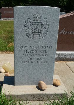
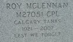

Roy Dawson McLennan
| Birth | : | 18 Apr 1921 Fort Macleod, Claresholm Census Division, Alberta, Canada |
| Death | : | 8 Dec 2007 Vulcan, Strathmore Census Division, Alberta, Canada |
| Burial | : | Vulcan Cemetery, Vulcan, Strathmore Census Division, Canada |
| Coordinate | : | 50.4032200, -113.2774100 |
| Plot | : | Block 10 Lot 1 Grave 35 |
| Description | : | LETHBRIDGE HERALD - DEC 11 2007 - born in Fort MacLeod - his mother died when he was 5 and Roy went to live in Carling, England - at age 8 yrs he returned to Pincher Creek, AB to live with his Aunt Mary & Uncle John - the youngest of 3 children, Jack of Pincher Creek & Edith of Burnaby, BC - served in WWII - returned to Canada and apprenticed as an auto mechanic - met and married Marjorie McNab of Fort MacLeod in 1948 - Marjorie was one of 9 siblings and her parents were Jim & Mary McNab - survived by his wife Marj, one... Read More |
frequently asked questions (FAQ):
-
Where is Roy Dawson McLennan's memorial?
Roy Dawson McLennan's memorial is located at: Vulcan Cemetery, Vulcan, Strathmore Census Division, Canada.
-
When did Roy Dawson McLennan death?
Roy Dawson McLennan death on 8 Dec 2007 in Vulcan, Strathmore Census Division, Alberta, Canada
-
Where are the coordinates of the Roy Dawson McLennan's memorial?
Latitude: 50.4032200
Longitude: -113.2774100
Family Members:
Parent
Spouse

Siblings
Flowers:


Nearby Cemetories:
1. Vulcan Cemetery
Vulcan, Strathmore Census Division, Canada
Coordinate: 50.4032200, -113.2774100
2. Highland Cemetery
Vulcan, Strathmore Census Division, Canada
Coordinate: 50.4845700, -113.2659100
3. Cleverville Cemetery
Champion, Strathmore Census Division, Canada
Coordinate: 50.2736100, -113.1661700
4. Reid Hill Cemetery
Vulcan, Strathmore Census Division, Canada
Coordinate: 50.3974000, -113.0295500
5. Brant Cemetery
Brant, Strathmore Census Division, Canada
Coordinate: 50.5067400, -113.5068000
6. Fath Hill Catholic Cemetery
Champion, Strathmore Census Division, Canada
Coordinate: 50.2153400, -113.2544200
7. Champion Cemetery
Champion, Strathmore Census Division, Canada
Coordinate: 50.2329200, -113.1441800
8. Sharon Cemetery
Brant, Strathmore Census Division, Canada
Coordinate: 50.4555300, -113.5740800
9. Little Bow Hutterite Cemetery
Stavely, Claresholm Census Division, Canada
Coordinate: 50.2142141, -113.3694417
10. Isol Russell Grave
Champion, Strathmore Census Division, Canada
Coordinate: 50.1792300, -113.2102100
11. Alston Cemetery
Vulcan, Strathmore Census Division, Canada
Coordinate: 50.1652820, -113.2450470
12. Arrowwood Hutterite Cemetery
Herronton, Strathmore Census Division, Canada
Coordinate: 50.6368299, -113.4157544
13. High River Hutterite Cemetery
High River, Calgary Census Division, Canada
Coordinate: 50.4816260, -113.6618863
14. Frankburg Cemetery
High River, Calgary Census Division, Canada
Coordinate: 50.5287300, -113.6445850
15. Krasivaya Dolina Cemetery
Queenstown, Strathmore Census Division, Canada
Coordinate: 50.5908100, -112.9593600
16. Carmangay Cemetery
Carmangay, Strathmore Census Division, Canada
Coordinate: 50.1214300, -113.1434300
17. Hope Lutheran Cemetery
Milo, Strathmore Census Division, Canada
Coordinate: 50.6013300, -112.9238900
18. Blackie Cemetery
Blackie, Calgary Census Division, Canada
Coordinate: 50.6084400, -113.6290500
19. St. Cecilia's Roman Catholic Cemetery
Nanton, Claresholm Census Division, Canada
Coordinate: 50.3588000, -113.7591600
20. Nanton Town Cemetery
Nanton, Claresholm Census Division, Canada
Coordinate: 50.3333800, -113.7586100
21. Saint Vincent Roman Catholic Cemetery
Stavely, Claresholm Census Division, Canada
Coordinate: 50.1717670, -113.6409830
22. Shadow Ranch Hutterite Cemetery
Champion, Strathmore Census Division, Canada
Coordinate: 50.1820466, -112.8929664
23. Arrowwood Cemetery
Arrowwood, Strathmore Census Division, Canada
Coordinate: 50.7211418, -113.1209030
24. Stavely Cemetery
Stavely, Claresholm Census Division, Canada
Coordinate: 50.1646700, -113.6625600