
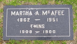
Martha Adeline “Mattie” Riffe McAfee
| Birth | : | 14 Mar 1861 California, USA |
| Death | : | 5 Feb 1951 Santa Barbara County, California, USA |
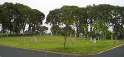
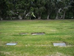
| Burial | : | Goleta Cemetery, Goleta, Santa Barbara County, USA |
| Coordinate | : | 34.4407997, -119.7802963 |
| Plot | : | 1 East- Lot- 7- Space- 6 |
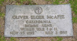
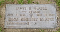
| Description | : | Daughter of John Riffe & Margaret Elizabeth Damron One of nine children; 6 sisters & 2 brothers *********************************** 1850 Quintella V. (Taylor)***see below 1852 Isaac Martin***see below 1856 Mary Elizabeth (Nuckolls)***see below 1857 Josephine Ceclia (Nuckolls)***see below 1859 Lydia Margaret (Smart)***see below 1866 Johanna Alexan (Griffin)***see below 1874 Charles Almond***see below 1878 Susan Esther (Reed)***see below Married Oliver Elger McAfee Mother of two sons ********************************** 1892 Oliver Elger, Jr.***see below 1896 James Henry***see below |
frequently asked questions (FAQ):
-
Where is Martha Adeline “Mattie” Riffe McAfee's memorial?
Martha Adeline “Mattie” Riffe McAfee's memorial is located at: Goleta Cemetery, Goleta, Santa Barbara County, USA.
-
When did Martha Adeline “Mattie” Riffe McAfee death?
Martha Adeline “Mattie” Riffe McAfee death on 5 Feb 1951 in Santa Barbara County, California, USA
-
Where are the coordinates of the Martha Adeline “Mattie” Riffe McAfee's memorial?
Latitude: 34.4407997
Longitude: -119.7802963
Family Members:
Parent
Siblings
Children


Nearby Cemetories:
1. Goleta Cemetery
Goleta, Santa Barbara County, USA
Coordinate: 34.4407997, -119.7802963
2. Cieneguitas Catholic Cemetery
La Patera, Santa Barbara County, USA
Coordinate: 34.4402920, -119.7744090
3. Potters Field Cemetery
Goleta, Santa Barbara County, USA
Coordinate: 34.4526310, -119.7686540
4. Christ the King Episcopal Church Memorial Garden
Santa Barbara, Santa Barbara County, USA
Coordinate: 34.4343418, -119.7998439
5. Calvary Cemetery
Santa Barbara, Santa Barbara County, USA
Coordinate: 34.4432983, -119.7466965
6. Mission Santa Barbara Cemetery
Santa Barbara, Santa Barbara County, USA
Coordinate: 34.4378800, -119.7134600
7. Presidio Cemetery
Santa Barbara, Santa Barbara County, USA
Coordinate: 34.4228790, -119.6991480
8. Santa Barbara Cemetery
Santa Barbara, Santa Barbara County, USA
Coordinate: 34.4188995, -119.6544037
9. All Saints By The Sea Episcopal Church Columbarium
Montecito, Santa Barbara County, USA
Coordinate: 34.4210500, -119.6312100
10. Montecito Cemetery
Montecito, Santa Barbara County, USA
Coordinate: 34.4363080, -119.5959850
11. Carpinteria Cemetery
Carpinteria, Santa Barbara County, USA
Coordinate: 34.4118996, -119.5385971
12. Ferrer Family Ranch Grounds
Carpinteria, Santa Barbara County, USA
Coordinate: 34.3821940, -119.4812560
13. Rancho del Cielo Cemetery
Santa Barbara, Santa Barbara County, USA
Coordinate: 34.5304780, -120.0758920
14. Capuchin Cemetery
Santa Ynez, Santa Barbara County, USA
Coordinate: 34.6442860, -120.0270440
15. Mission Santa Ines Cemetery
Solvang, Santa Barbara County, USA
Coordinate: 34.5943880, -120.1365550
16. Oak Hill Cemetery
Ballard, Santa Barbara County, USA
Coordinate: 34.6324997, -120.1106033
17. Solvang Cemetery
Solvang, Santa Barbara County, USA
Coordinate: 34.6017000, -120.1443920
18. Saint Mark's-in-the-Valley Church Mem. Garden
Los Olivos, Santa Barbara County, USA
Coordinate: 34.6662590, -120.1177210
19. Ojai United Methodist Memorial Garden
Ojai, Ventura County, USA
Coordinate: 34.4437040, -119.2665540
20. Saint Thomas Aquinas Cemetery
Ojai, Ventura County, USA
Coordinate: 34.4301250, -119.2650250
21. Nordhoff Cemetery
Ojai, Ventura County, USA
Coordinate: 34.4446600, -119.2604400
22. Mission San Buenaventura Cemetery
Ventura, Ventura County, USA
Coordinate: 34.2811890, -119.2982090
23. Ojai Presbyterian Church Columbarium
Ojai, Ventura County, USA
Coordinate: 34.4494250, -119.2530420
24. Saint Andrews Episcopal Church Columbarium
Ojai, Ventura County, USA
Coordinate: 34.4454300, -119.2513700