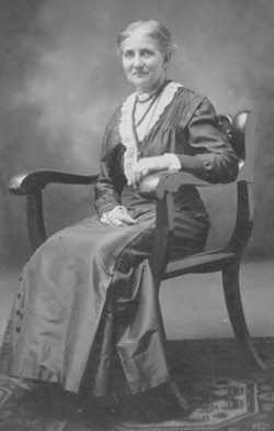
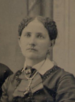
Martha Angeline Bucy Waud
| Birth | : | 17 Jan 1857 Millersburg, Holmes County, Ohio, USA |
| Death | : | 1 Nov 1920 Crocker, Polk County, Iowa, USA |
| Burial | : | Droylsden Cemetery, Droylsden, Metropolitan Borough of Tameside, England |
| Coordinate | : | 53.4849400, -2.1529696 |
| Description | : | Known as Angie. Local newspaper obituary: MRS. CHAS. C. WAUD DIES SUDDENLY MONDAY NIGHT Mrs. Angeline Waud, wife of Mr. Charles C. Waud, died very suddenly last Monday morning at her home here. Death was due to heart disease. Mrs. Waud had been suffering for nearly two years, but it was not believed by her husband or her neighbors and friends that death was dangerously near her. In fact she seemed to be gradually recovering. Up to the time of her death she had remained hopeful that finally she would recover, and with the assistance of her husband she had continued to attend... Read More |
frequently asked questions (FAQ):
-
Where is Martha Angeline Bucy Waud's memorial?
Martha Angeline Bucy Waud's memorial is located at: Droylsden Cemetery, Droylsden, Metropolitan Borough of Tameside, England.
-
When did Martha Angeline Bucy Waud death?
Martha Angeline Bucy Waud death on 1 Nov 1920 in Crocker, Polk County, Iowa, USA
-
Where are the coordinates of the Martha Angeline Bucy Waud's memorial?
Latitude: 53.4849400
Longitude: -2.1529696
Family Members:
Parent
Siblings
Flowers:
Nearby Cemetories:
1. Droylsden Cemetery
Droylsden, Metropolitan Borough of Tameside, England
Coordinate: 53.4849400, -2.1529696
2. St Cross Churchyard
Clayton, Metropolitan Borough of Manchester, England
Coordinate: 53.4832190, -2.1823530
3. Failsworth Cemetery
Failsworth, Metropolitan Borough of Oldham, England
Coordinate: 53.5048760, -2.1537550
4. Failsworth Jewish Cemetery
Failsworth, Metropolitan Borough of Oldham, England
Coordinate: 53.5050270, -2.1534220
5. All Saints Churchyard
Newton Heath, Metropolitan Borough of Manchester, England
Coordinate: 53.5002260, -2.1777970
6. Saint Stephens Churchyard
Audenshaw, Metropolitan Borough of Tameside, England
Coordinate: 53.4753000, -2.1151700
7. St. Peter's Churchyard
Ashton-Under-Lyne, Metropolitan Borough of Tameside, England
Coordinate: 53.4839340, -2.1054690
8. Philips Park Cemetery
Miles Platting, Metropolitan Borough of Manchester, England
Coordinate: 53.4898020, -2.2007400
9. Gorton Cemetery
Manchester, Metropolitan Borough of Manchester, England
Coordinate: 53.4567080, -2.1632580
10. Audenshaw Cemetery
Audenshaw, Metropolitan Borough of Tameside, England
Coordinate: 53.4653300, -2.1101560
11. Oldham Crematorium
Oldham, Metropolitan Borough of Oldham, England
Coordinate: 53.5156810, -2.1332800
12. Christ Church Churchyard
Denton, Metropolitan Borough of Tameside, England
Coordinate: 53.4560270, -2.1218270
13. Hollinwood Cemetery
Oldham, Metropolitan Borough of Oldham, England
Coordinate: 53.5178170, -2.1329170
14. Saint Mary's Churchyard
Moston, Metropolitan Borough of Manchester, England
Coordinate: 53.5181740, -2.1763410
15. St. Joseph's Roman Catholic Churchyard
Moston, Metropolitan Borough of Manchester, England
Coordinate: 53.5149270, -2.1877070
16. Dukinfield Cemetery and Crematorium
Dukinfield, Metropolitan Borough of Tameside, England
Coordinate: 53.4800300, -2.0857150
17. Former Saint Johns Churchyard
Longsight, Metropolitan Borough of Manchester, England
Coordinate: 53.4570760, -2.2025800
18. St Lawrence Church
Denton, Metropolitan Borough of Tameside, England
Coordinate: 53.4520000, -2.1109000
19. All Saints Churchyard
Chorlton-on-Medlock, Metropolitan Borough of Manchester, England
Coordinate: 53.4666670, -2.2166670
20. Manchester General Cemetery
Manchester, Metropolitan Borough of Manchester, England
Coordinate: 53.5062710, -2.2179570
21. St Thomas Churchyard
Ardwick, Metropolitan Borough of Manchester, England
Coordinate: 53.4720000, -2.2248900
22. Christchurch Harpurhey Churchyard
Harpurhey, Metropolitan Borough of Manchester, England
Coordinate: 53.5115100, -2.2134800
23. St. John the Evangelist Churchyard
Hurst, Metropolitan Borough of Tameside, England
Coordinate: 53.5001310, -2.0812490
24. St Elisabeth Church
Reddish, Metropolitan Borough of Stockport, England
Coordinate: 53.4379400, -2.1633950


