
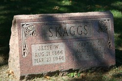
Martha Celia Jarvis Skaggs
| Birth | : | 21 Aug 1867 Washington County, Missouri, USA |
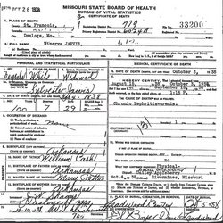
| Death | : | 29 Apr 1952 Esther, St. Francois County, Missouri, USA |
| Burial | : | St. Luke's Churchyard, North Carlton, West Lindsey District, England |
| Coordinate | : | 53.2873000, -0.5831200 |
frequently asked questions (FAQ):
-
Where is Martha Celia Jarvis Skaggs's memorial?
Martha Celia Jarvis Skaggs's memorial is located at: St. Luke's Churchyard, North Carlton, West Lindsey District, England.
-
When did Martha Celia Jarvis Skaggs death?
Martha Celia Jarvis Skaggs death on 29 Apr 1952 in Esther, St. Francois County, Missouri, USA
-
Where are the coordinates of the Martha Celia Jarvis Skaggs's memorial?
Latitude: 53.2873000
Longitude: -0.5831200
Family Members:
Spouse

Children

Flowers:


Nearby Cemetories:
1. St. Luke's Churchyard
North Carlton, West Lindsey District, England
Coordinate: 53.2873000, -0.5831200
2. St. John the Baptist Churchyard
South Carlton, West Lindsey District, England
Coordinate: 53.2785000, -0.5754000
3. St. John the Baptist Churchyard
Scampton, West Lindsey District, England
Coordinate: 53.3037680, -0.5787140
4. St Peter's Churchyard
Aisthorpe, West Lindsey District, England
Coordinate: 53.3102400, -0.5815300
5. Dam Busters Dog Memorial
Scampton, West Lindsey District, England
Coordinate: 53.3008200, -0.5495800
6. St Cuthbert's Churchyard
Brattleby, West Lindsey District, England
Coordinate: 53.3156600, -0.5794750
7. St. Vincent Churchyard
Burton, West Lindsey District, England
Coordinate: 53.2596400, -0.5598100
8. All Saints Churchyard
Broxholme, West Lindsey District, England
Coordinate: 53.2922400, -0.6349600
9. St. Mary's Churchyard
Riseholme, West Lindsey District, England
Coordinate: 53.2688200, -0.5264900
10. St. Michael's Churchyard
Cammeringham, West Lindsey District, England
Coordinate: 53.3275480, -0.5781450
11. Saxilby Cemetery
Saxilby, West Lindsey District, England
Coordinate: 53.2755800, -0.6590400
12. St. Botolph Churchyard
Saxilby, West Lindsey District, England
Coordinate: 53.2747300, -0.6591000
13. All Saints Churchyard
Ingham, West Lindsey District, England
Coordinate: 53.3398690, -0.5745610
14. St Nicholas Parish Churchyard
Lincoln, City of Lincoln, England
Coordinate: 53.2400800, -0.5376400
15. Newport Cemetery
Lincoln, City of Lincoln, England
Coordinate: 53.2405150, -0.5362590
16. Woodbank Cemetery
Skellingthorpe, North Kesteven District, England
Coordinate: 53.2375380, -0.6229660
17. Saint Mary Magdalene in the Bail Churchyard
Lincoln, City of Lincoln, England
Coordinate: 53.2366000, -0.5402700
18. Sturton by Stow Quaker Cemetery
Sturton-by-Stow, West Lindsey District, England
Coordinate: 53.3173590, -0.6644260
19. Lincoln Castle Cemetery
Lincoln, City of Lincoln, England
Coordinate: 53.2342640, -0.5415700
20. St Michael Churchyard
Hackthorn, West Lindsey District, England
Coordinate: 53.3288810, -0.5134350
21. Eastgate Cemetery
Lincoln, City of Lincoln, England
Coordinate: 53.2371410, -0.5312100
22. St. Edith Churchyard
Coates-by-Stow, West Lindsey District, England
Coordinate: 53.3369700, -0.6377300
23. All Saints Churchyard
Nettleham, West Lindsey District, England
Coordinate: 53.2652940, -0.4906780
24. St. Peter in Eastgate Churchyard
Lincoln, City of Lincoln, England
Coordinate: 53.2355350, -0.5335080