
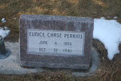
Martha Eunice “Eunice” Chase Perkins
| Birth | : | 4 Jun 1896 Loup City, Sherman County, Nebraska, USA |
| Death | : | 27 Oct 1981 Lincoln, Lancaster County, Nebraska, USA |
| Burial | : | Chester Cemetery, Chester, Liberty County, USA |
| Coordinate | : | 48.5219002, -110.9807968 |
| Description | : | buried Oct 30, 1981 Lot 562E |
frequently asked questions (FAQ):
-
Where is Martha Eunice “Eunice” Chase Perkins's memorial?
Martha Eunice “Eunice” Chase Perkins's memorial is located at: Chester Cemetery, Chester, Liberty County, USA.
-
When did Martha Eunice “Eunice” Chase Perkins death?
Martha Eunice “Eunice” Chase Perkins death on 27 Oct 1981 in Lincoln, Lancaster County, Nebraska, USA
-
Where are the coordinates of the Martha Eunice “Eunice” Chase Perkins's memorial?
Latitude: 48.5219002
Longitude: -110.9807968
Family Members:
Parent

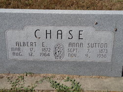
Spouse
Siblings
Flowers:


Nearby Cemetories:
1. Chester Cemetery
Chester, Liberty County, USA
Coordinate: 48.5219002, -110.9807968
2. Joplin Cemetery
Joplin, Liberty County, USA
Coordinate: 48.5576720, -110.7622930
3. Lothair Protestant Cemetery
Lothair, Liberty County, USA
Coordinate: 48.4694000, -111.2393100
4. Lothair Catholic Cemetery
Lothair, Liberty County, USA
Coordinate: 48.4687000, -111.2484000
5. Erickson Cemetery
Liberty County, USA
Coordinate: 48.3143997, -110.9503021
6. Inverness Cemetery
Hill County, USA
Coordinate: 48.5531340, -110.6688450
7. Eagle Creek Colony Cemetery
Chester, Liberty County, USA
Coordinate: 48.6976000, -111.2011000
8. Galata Cemetery
Toole County, USA
Coordinate: 48.4655991, -111.3349991
9. Trinity Church Cemetery
Lothair, Liberty County, USA
Coordinate: 48.7263000, -111.2296000
10. Bethel Cemetery
Hill County, USA
Coordinate: 48.6685982, -110.6406021
11. Rudyard Cemetery
Rudyard, Hill County, USA
Coordinate: 48.5659500, -110.5390000
12. Grandview Cemetery
Toole County, USA
Coordinate: 48.7265000, -111.3615000
13. Devon Cemetery
Toole County, USA
Coordinate: 48.4693000, -111.4713000
14. Riverview Colony Cemetery
Riverview Colony, Liberty County, USA
Coordinate: 48.1762000, -111.0315000
15. Saint Olaf Lutheran Cemetery
Toole County, USA
Coordinate: 48.2479000, -111.3182000
16. Cool Spring Colony Cemetery
Rudyard, Hill County, USA
Coordinate: 48.7704000, -110.5860000
17. Wolf Cemetery
Liberty County, USA
Coordinate: 48.1617620, -110.9984420
18. Hingham Union Cemetery
Hingham, Hill County, USA
Coordinate: 48.5601570, -110.4178980
19. Grace Church Cemetery
Rudyard, Hill County, USA
Coordinate: 48.8269930, -110.6209890
20. Old Indian Cemetery
Liberty County, USA
Coordinate: 48.8680992, -111.2585983
21. Sage Creek Colony Cemetery
Sage Creek Colony, Liberty County, USA
Coordinate: 48.9271000, -110.9735000
22. Omholt Cemetery
Toole County, USA
Coordinate: 48.3058014, -111.5346985
23. Whitlash Cemetery
Liberty County, USA
Coordinate: 48.9085999, -111.2699966
24. Gold Butte Cemetery
Toole County, USA
Coordinate: 48.8793983, -111.3966980