

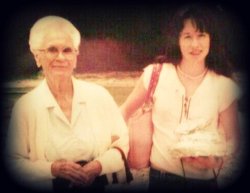
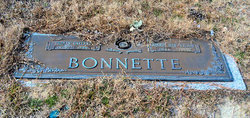
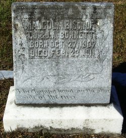
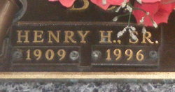
Martha Gretchen Bonnette Reed
| Birth | : | 18 Sep 1914 Orangeburg County, South Carolina, USA |
| Death | : | 8 Jan 2008 Orangeburg, Orangeburg County, South Carolina, USA |
| Burial | : | Barnston Cemetery, Barnston, Metropolitan Borough of Wirral, England |
| Coordinate | : | 53.3408590, -3.0820730 |
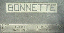
| Description | : | Orangeburg - Mrs. Martha Bonnette Reed, 93, of 1000 Methodist Oaks Drive, Orangeburg, died Tuesday, January 8, 2008, at The Oaks. Funeral services will be held at 3 p.m. Thursday, January 10, in the Bethany Baptist Church, with the Rev. Steve Scott officiating. Burial will be in the Bethany Baptist Church Cemetery. Mrs. Reed was born in Orangeburg County, a daughter of the late Thomas Jefferson Bonnette and Alice Bolen Bonnette. She was retired from Utica Tool Company and was formerly an executive secretary to the Manager of Hygrade Meat Products Company. She was a former member of the Business... Read More |
frequently asked questions (FAQ):
-
Where is Martha Gretchen Bonnette Reed's memorial?
Martha Gretchen Bonnette Reed's memorial is located at: Barnston Cemetery, Barnston, Metropolitan Borough of Wirral, England.
-
When did Martha Gretchen Bonnette Reed death?
Martha Gretchen Bonnette Reed death on 8 Jan 2008 in Orangeburg, Orangeburg County, South Carolina, USA
-
Where are the coordinates of the Martha Gretchen Bonnette Reed's memorial?
Latitude: 53.3408590
Longitude: -3.0820730
Family Members:
Parent

Spouse

Siblings
Flowers:


Nearby Cemetories:
1. Barnston Cemetery
Barnston, Metropolitan Borough of Wirral, England
Coordinate: 53.3408590, -3.0820730
2. Heswall Cemetery
Heswall, Metropolitan Borough of Wirral, England
Coordinate: 53.3400420, -3.1102790
3. St Peter's Churchyard
Heswall, Metropolitan Borough of Wirral, England
Coordinate: 53.3227400, -3.1036400
4. Landican Cemetery and Crematorium
Woodchurch, Metropolitan Borough of Wirral, England
Coordinate: 53.3654000, -3.0887510
5. All Saints Churchyard
Thornton Hough, Metropolitan Borough of Wirral, England
Coordinate: 53.3203500, -3.0444780
6. St Bartholomew's Churchyard
Thurstaston, Metropolitan Borough of Wirral, England
Coordinate: 53.3485750, -3.1320070
7. Holy Cross Churchyard
Woodchurch, Metropolitan Borough of Wirral, England
Coordinate: 53.3731900, -3.0899400
8. Christ Church
Bebington, Metropolitan Borough of Wirral, England
Coordinate: 53.3584460, -3.0254810
9. Salacre Lane Cemetery
Upton, Metropolitan Borough of Wirral, England
Coordinate: 53.3824050, -3.0919920
10. Bebington Cemetery
Bebington, Metropolitan Borough of Wirral, England
Coordinate: 53.3588030, -3.0165370
11. Saint Mary's Churchyard
Upton, Metropolitan Borough of Wirral, England
Coordinate: 53.3847010, -3.0961600
12. St. John the Divine
Frankby, Metropolitan Borough of Wirral, England
Coordinate: 53.3744200, -3.1330200
13. Frankby Cemetery
Frankby, Metropolitan Borough of Wirral, England
Coordinate: 53.3715920, -3.1399600
14. St Andrews Parish Churchyard
Bebington, Metropolitan Borough of Wirral, England
Coordinate: 53.3479800, -3.0035400
15. Neston Cemetery
Neston, Cheshire West and Chester Unitary Authority, England
Coordinate: 53.2943100, -3.0571400
16. St Paul's
Tranmere, Metropolitan Borough of Wirral, England
Coordinate: 53.3740000, -3.0154600
17. St Mary and St Helen Neston
Neston, Cheshire West and Chester Unitary Authority, England
Coordinate: 53.2892600, -3.0640600
18. Christ Church Churchyard
Port Sunlight, Metropolitan Borough of Wirral, England
Coordinate: 53.3534920, -2.9953750
19. St. Peter's Churchyard
Bebington, Metropolitan Borough of Wirral, England
Coordinate: 53.3692500, -3.0021020
20. Flaybrick Memorial Gardens
Birkenhead, Metropolitan Borough of Wirral, England
Coordinate: 53.3968130, -3.0633240
21. Saint Winefride Churchyard
Little Neston, Cheshire West and Chester Unitary Authority, England
Coordinate: 53.2849200, -3.0592100
22. St. Werburgh & St. Laurence Catholic Churchyard
Birkenhead, Metropolitan Borough of Wirral, England
Coordinate: 53.3894910, -3.0217530
23. Christ Church Churchyard
Moreton, Metropolitan Borough of Wirral, England
Coordinate: 53.3999580, -3.1112310
24. Grange Cemetery
West Kirby, Metropolitan Borough of Wirral, England
Coordinate: 53.3751630, -3.1682120