
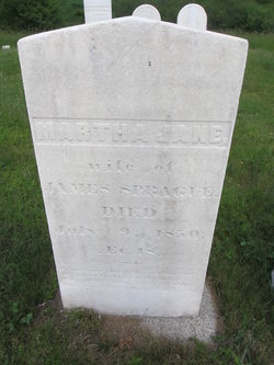
Martha Jane Moody Sprague
| Birth | : | 14 Jul 1832 Nobleboro, Lincoln County, Maine, USA |
| Death | : | 9 Jul 1850 Nobleboro, Lincoln County, Maine, USA |
| Burial | : | Holy Trinity Church Burial, Sunderland, Metropolitan Borough of Sunderland, England |
| Coordinate | : | 54.9077830, -1.3688030 |
| Inscription | : | Friends nor physician could not save, My mortal body from the grave, Nor can the grave confine it here, When Christ the judge bid one appear. |
| Description | : | 18y |
frequently asked questions (FAQ):
-
Where is Martha Jane Moody Sprague's memorial?
Martha Jane Moody Sprague's memorial is located at: Holy Trinity Church Burial, Sunderland, Metropolitan Borough of Sunderland, England.
-
When did Martha Jane Moody Sprague death?
Martha Jane Moody Sprague death on 9 Jul 1850 in Nobleboro, Lincoln County, Maine, USA
-
Where are the coordinates of the Martha Jane Moody Sprague's memorial?
Latitude: 54.9077830
Longitude: -1.3688030
Family Members:
Parent
Spouse
Siblings


Flowers:


Nearby Cemetories:
1. Sunderland Friends Burial Ground
Sunderland, Metropolitan Borough of Sunderland, England
Coordinate: 54.9059650, -1.3768230
2. St. Thomas' Church
Sunderland, Metropolitan Borough of Sunderland, England
Coordinate: 54.9066294, -1.3804475
3. St Michael's Minster Church
Sunderland, Metropolitan Borough of Sunderland, England
Coordinate: 54.9059555, -1.3887787
4. Galley's Gill Cemetery
Sunderland, Metropolitan Borough of Sunderland, England
Coordinate: 54.9082914, -1.3913108
5. Jewish Burial Ground
Ayre's Quay, Metropolitan Borough of Sunderland, England
Coordinate: 54.9115200, -1.3960100
6. Sunderland Cemetery
Sunderland, Metropolitan Borough of Sunderland, England
Coordinate: 54.8833700, -1.3660100
7. Holy Trinity Churchyard
Southwick, Metropolitan Borough of Sunderland, England
Coordinate: 54.9203120, -1.4060260
8. Mere Knolls Cemetery
Sunderland, Metropolitan Borough of Sunderland, England
Coordinate: 54.9342990, -1.3738590
9. St Peters Parish Churchyard
Monkwearmouth, Metropolitan Borough of Sunderland, England
Coordinate: 54.9341667, -1.3813889
10. Bishopwearmouth Cemetery
Bishopwearmouth, Metropolitan Borough of Sunderland, England
Coordinate: 54.8996124, -1.4206740
11. Sunderland Crematorium
Sunderland, Metropolitan Borough of Sunderland, England
Coordinate: 54.8970430, -1.4216890
12. Southwick Cemetery
Southwick, Metropolitan Borough of Sunderland, England
Coordinate: 54.9269940, -1.4165070
13. St Leonard RC
Silksworth, Metropolitan Borough of Sunderland, England
Coordinate: 54.8736400, -1.3971900
14. Ryhope Cemetery
Ryhope, Metropolitan Borough of Sunderland, England
Coordinate: 54.8681320, -1.3708760
15. St Mary Churchyard
Whitburn, Metropolitan Borough of South Tyneside, England
Coordinate: 54.9480000, -1.3681200
16. St Matthew's Churchyard
Silksworth, Metropolitan Borough of Sunderland, England
Coordinate: 54.8707006, -1.4090075
17. Whitburn Cemetery
Whitburn, Metropolitan Borough of South Tyneside, England
Coordinate: 54.9525060, -1.3644680
18. St Katherine's Chapel
Sunderland, Metropolitan Borough of Sunderland, England
Coordinate: 54.9228508, -1.4422613
19. Castletown Cemetery
Castletown, Metropolitan Borough of Sunderland, England
Coordinate: 54.9167340, -1.4467910
20. St Mary's Church
South Hylton, Metropolitan Borough of Sunderland, England
Coordinate: 54.9064500, -1.4505300
21. Boldon Cemetery
West Boldon, Metropolitan Borough of South Tyneside, England
Coordinate: 54.9422300, -1.4491100
22. Boldon Friends Burial Ground
Boldon, Metropolitan Borough of South Tyneside, England
Coordinate: 54.9424130, -1.4549390
23. Seaham Cemetery
Seaham, Durham Unitary Authority, England
Coordinate: 54.8493205, -1.3414431
24. St Mary's Churchyard
Seaham, Durham Unitary Authority, England
Coordinate: 54.8475590, -1.3435800